Property Record
22584 147Th St, Basehor, KS 66007
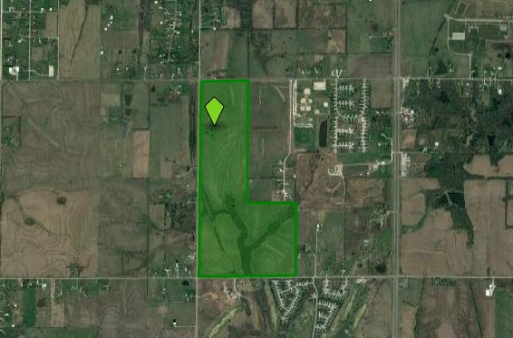

Property Detail
22584 147Th St
156-13-0-00-00-005.00-0
S13, T10, R22E, ACRES 4.85, COMM S 1275 AT THE NW COR OF NW QRT OF SEC13-10-22. THEN E 615, S 355, W 615, N 355 TO THE POB
Agriculturalland
Leavenworth
AE The base floodplain where base flood elevations are provided. AE Zones are now used on new format FIRMs instead of A1-A30 Zones.
Kansas
2024
4.85 AC
2025
Leavenworth County
071205
Kansas City
3,150 SF
Kansas City, MO-KS
NEARBY LISTINGS FOR SALE OR LEASE
-
-
View all Basehor listings for sale on LoopNet.com
DEMOGRAPHICS near 22584 147Th St
1 mile
3 mile
5 mile
2025 Total Population
821
6,770
27,457
2030 Population
868
7,016
28,190
Pop Growth 2025-2030
+ 5.72%
+ 3.63%
+ 2.67%
Average Age
42
42
40
2025 Total Households
297
2,398
9,324
HH Growth 2025-2030
+ 5.72%
+ 3.88%
+ 2.79%
Median Household Inc
$153,261
$126,051
$110,193
Avg Household Size
2.80
2.80
2.70
2025 Avg HH Vehicles
3.00
2.00
2.00
Median Home Value
$408,602
$371,507
$339,596
Median Year Built
2005
2001
1999
Nearby Places
Map Layers
Map Styles
 Street
 Aerial
Layers
 Traffic
 Biking
Places
Listings with unknown addresses are not visible on the map
- Restaurants
- Banks
- Shops
- Fitness
- Groceries
PUBLIC TRANSPORTATION
AIRPORT
Kansas City International
Drive
Walk
Distance
Kansas City International
38 min
27.4 mi
Freight Ports
Tulsa Port Of Catoosa
Drive
Walk
Distance
Tulsa Port Of Catoosa
282 min
250.5 mi
Nearby Properties
Address
Land Use
TOTAL SIZE
Lot Size
Zoning
Address
Land Use
TOTAL SIZE
Lot Size
Zoning
27,279 SF
17.93 AC
Address
Land Use
TOTAL SIZE
Lot Size
Zoning
39,215 SF
18.35 AC
Address
Land Use
TOTAL SIZE
Lot Size
Zoning
27,568 SF
6.57 AC
WR1
Address
Land Use
TOTAL SIZE
Lot Size
Zoning
30,800 SF
108.93 AC
WYAG
Address
Land Use
TOTAL SIZE
Lot Size
Zoning
20,573 SF
4.60 AC
Address
Land Use
TOTAL SIZE
Lot Size
Zoning
61.74 AC
WYAG
Address
Land Use
TOTAL SIZE
Lot Size
Zoning
17,592 SF
203.39 AC
WAG
Address
Land Use
TOTAL SIZE
Lot Size
Zoning
3,801 SF
9.51 AC
WR1
Address
Land Use
TOTAL SIZE
Lot Size
Zoning
2,628 SF
19.44 AC
WAG
Address
Land Use
TOTAL SIZE
Lot Size
Zoning
271,824 SF
137.72 AC
WAG
Address
Land Use
TOTAL SIZE
Lot Size
Zoning
4,212 SF
9.85 AC
Address
Land Use
TOTAL SIZE
Lot Size
Zoning
7,952 SF
1 AC
Address
Land Use
TOTAL SIZE
Lot Size
Zoning
18,156 SF
175.09 AC
Address
Land Use
TOTAL SIZE
Lot Size
Zoning
1,067 SF
14.86 AC
Address
Land Use
TOTAL SIZE
Lot Size
Zoning
22,672 SF
7.61 AC
Address
Land Use
TOTAL SIZE
Lot Size
Zoning
6,582 SF
2.06 AC
Address
Land Use
TOTAL SIZE
Lot Size
Zoning
1,296 SF
15.26 AC
Address
Land Use
TOTAL SIZE
Lot Size
Zoning
46,765 SF
142.54 AC
WAG
Address
Land Use
TOTAL SIZE
Lot Size
Zoning
18,946 SF
3.58 AC
Address
Land Use
TOTAL SIZE
Lot Size
Zoning
13,860 SF
21.02 AC
WCP2
Address
Land Use
TOTAL SIZE
Lot Size
Zoning
3,472 SF
1.14 AC
Address
Land Use
TOTAL SIZE
Lot Size
Zoning
15.04 AC
Address
Land Use
TOTAL SIZE
Lot Size
Zoning
8,414 SF
80.08 AC
WAG
Address
Land Use
TOTAL SIZE
Lot Size
Zoning
10,182 SF
2.21 AC
Address
Land Use
TOTAL SIZE
Lot Size
Zoning
8,770 SF
52.91 AC
Address
Land Use
TOTAL SIZE
Lot Size
Zoning
7,146 SF
37.73 AC
Address
Land Use
TOTAL SIZE
Lot Size
Zoning
36.38 AC
Address
Land Use
TOTAL SIZE
Lot Size
Zoning
9,944 SF
83.09 AC
Address
Land Use
TOTAL SIZE
Lot Size
Zoning
8,143 SF
69.95 AC
Address
Land Use
TOTAL SIZE
Lot Size
Zoning
5,144 SF
71.30 AC
The World's #1 Commercial Real Estate Marketplace
Connect with us
© 2026 CoStar Group
The information above has been obtained from sources believed reliable. While we do not doubt its accuracy we have not verified it and make no guarantee, warranty or representation about it. It is your responsibility to independently confirm its accuracy and completeness. Any projections, opinions, assumptions, or estimates used are for example only and do not represent the current or future performance of the property. The value of this transaction to you depends on tax and other factors which should be evaluated by your tax, financial, and legal advisors. You and your advisors should conduct a careful, independent investigation of the property to determine to your satisfaction the suitability of the property for your needs.