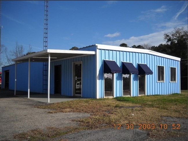
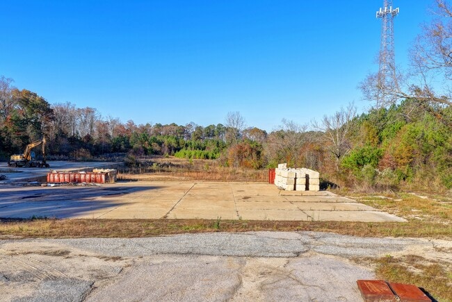
Property Record
2259 Greenville Rd, Lagrange, GA 30241
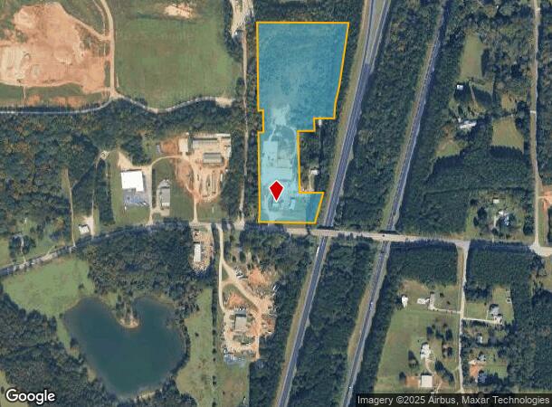
NEARBY LISTINGS FOR SALE OR LEASE
Property Detail
2259 Greenville Rd
039-4-000-027
Beaver Cove
Officebuilding
2259 GREENVILLE RD/LL-92,101 6TH TR 2 PB 39 P
X
Troup
13285C0162E
Georgia
2024
13.27 AC
2024
Troup County
960504
Columbus GA
3,075 SF
LaGrange, GA
DEMOGRAPHICS near 2259 Greenville Rd
1 Mile
3 Mile
5 Mile
2024 Total Population
172
7,090
27,439
2029 Population
179
7,335
28,061
Pop Growth 2024-2029
+ 4.07%
+ 3.46%
+ 2.27%
Average Age
40
39
38
2024 Total Households
57
2,637
10,523
HH Growth 2024-2029
+ 3.51%
+ 3.53%
+ 2.28%
Median Household Inc
$67,500
$52,763
$44,148
Avg Household Size
2.80
2.60
2.50
2024 Avg HH Vehicles
2.00
2.00
2.00
Median Home Value
$199,999
$188,706
$148,160
Median Year Built
1994
1991
1984
Nearby Places
- Restaurants
- Banks
- Shops
- Fitness
- Groceries
SALE & LEASE HISTORY
LISTING DATE
SALE/LEASE

Nov 24, 2025
For Sale
Mar 21, 2024
For Sale
Nearby Properties
Address
Land Use
TOTAL SIZE
Lot Size
Zoning
Address
Land Use
TOTAL SIZE
Lot Size
Zoning
Address
Land Use
TOTAL SIZE
Lot Size
Zoning
28,575 SF
45.67 AC
16- CR-MX
Address
Land Use
TOTAL SIZE
Lot Size
Zoning
845,961 SF
214.16 AC
16- CP-GI
Address
Land Use
TOTAL SIZE
Lot Size
Zoning
25,314 SF
25.48 AC
16- AC-MR
Address
Land Use
TOTAL SIZE
Lot Size
Zoning
2,152 SF
21.70 AC
16- CR-MR
Address
Land Use
TOTAL SIZE
Lot Size
Zoning
117,684 SF
12.61 AC
16- AC-MX
Address
Land Use
TOTAL SIZE
Lot Size
Zoning
Address
Land Use
TOTAL SIZE
Lot Size
Zoning
190,149 SF
20.67 AC
16- CP-GI
Address
Land Use
TOTAL SIZE
Lot Size
Zoning
3,798 SF
22.81 AC
16- CR-MR
Address
Land Use
TOTAL SIZE
Lot Size
Zoning
136,640 SF
41.91 AC
16- CP-GI
Address
Land Use
TOTAL SIZE
Lot Size
Zoning
Address
Land Use
TOTAL SIZE
Lot Size
Zoning
8,448 SF
25.78 AC
16- CR-MX
Address
Land Use
TOTAL SIZE
Lot Size
Zoning
202,500 SF
17.55 AC
16- CP-GI
Address
Land Use
TOTAL SIZE
Lot Size
Zoning
125,467 SF
35.19 AC
16- CR-MX
Address
Land Use
TOTAL SIZE
Lot Size
Zoning
34,380 SF
59.74 AC
16- CR-MX
Address
Land Use
TOTAL SIZE
Lot Size
Zoning
Address
Land Use
TOTAL SIZE
Lot Size
Zoning
84,400 SF
23.54 AC
16- CP-GI
Address
Land Use
TOTAL SIZE
Lot Size
Zoning
Address
Land Use
TOTAL SIZE
Lot Size
Zoning
11,000 SF
49.57 AC
01-SFMD
Address
Land Use
TOTAL SIZE
Lot Size
Zoning
22,368 SF
2.94 AC
16- AC-MX
Address
Land Use
TOTAL SIZE
Lot Size
Zoning
37,348 SF
26.89 AC
16- CR-MX
Address
Land Use
TOTAL SIZE
Lot Size
Zoning
9,000 SF
7.84 AC
16- CR-MX
Address
Land Use
TOTAL SIZE
Lot Size
Zoning
56,992 SF
4.44 AC
16- CR-MX
Address
Land Use
TOTAL SIZE
Lot Size
Zoning
52,148 SF
7.33 AC
16- CR-MX
Address
Land Use
TOTAL SIZE
Lot Size
Zoning
113.43 AC
16- CP-GI
Address
Land Use
TOTAL SIZE
Lot Size
Zoning
38,947 SF
9.57 AC
16- CP-GI
Address
Land Use
TOTAL SIZE
Lot Size
Zoning
17,626 SF
11.58 AC
16- CR-MX
Address
Land Use
TOTAL SIZE
Lot Size
Zoning
35,512 SF
2.64 AC
16- CR-MX
Address
Land Use
TOTAL SIZE
Lot Size
Zoning
25,019 SF
1.98 AC
16- AC-MX
Address
Land Use
TOTAL SIZE
Lot Size
Zoning
33,598 SF
11.12 AC
16- CR-MX
The World's #1 Commercial Real Estate Marketplace
Connect with us
© 2025 CoStar Group
The information above has been obtained from sources believed reliable. While we do not doubt its accuracy we have not verified it and make no guarantee, warranty or representation about it. It is your responsibility to independently confirm its accuracy and completeness. Any projections, opinions, assumptions, or estimates used are for example only and do not represent the current or future performance of the property. The value of this transaction to you depends on tax and other factors which should be evaluated by your tax, financial, and legal advisors. You and your advisors should conduct a careful, independent investigation of the property to determine to your satisfaction the suitability of the property for your needs.