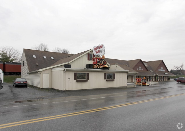
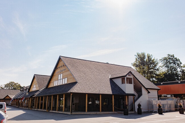
Property Record
226 Gap Rd, Ronks, PA 17572
Current Lease Availabilities
NEARBY LISTINGS FOR SALE OR LEASE
-
-
View all Ronks listings for lease on LoopNet.com
Property Detail
226 Gap Rd
580-13441-0-0000
226 GAP RD
Regionalshoppingcenterormallwithanchorstore
Lancaster
X
Pennsylvania
42071C0535F
11
2024
1.70 AC
2025
Lancaster County
014000
Philadelphia
20,716 SF
Lancaster, PA
DEMOGRAPHICS near 226 Gap Rd
1 Mile
3 Mile
5 Mile
2024 Total Population
2,280
9,561
28,191
2029 Population
2,282
9,553
28,142
Pop Growth 2024-2029
+ 0.09%
(0.08%)
(0.17%)
Average Age
40
38
38
2024 Total Households
842
3,272
9,541
HH Growth 2024-2029
+ 0.12%
0.00%
(0.10%)
Median Household Inc
$85,151
$85,012
$84,130
Avg Household Size
2.70
2.90
2.90
2024 Avg HH Vehicles
2.00
2.00
2.00
Median Home Value
$262,878
$287,347
$309,384
Median Year Built
1968
1968
1977
Nearby Places
- Restaurants
- Banks
- Shops
- Fitness
- Groceries
Nearby Properties
Address
Land Use
TOTAL SIZE
Lot Size
Zoning
Address
Land Use
TOTAL SIZE
Lot Size
Zoning
221,609 SF
62.37 AC
HC
Address
Land Use
TOTAL SIZE
Lot Size
Zoning
113,272 SF
13.80 AC
RC
Address
Land Use
TOTAL SIZE
Lot Size
Zoning
46,926 SF
3.12 AC
Address
Land Use
TOTAL SIZE
Lot Size
Zoning
55,546 SF
9.70 AC
C-2
Address
Land Use
TOTAL SIZE
Lot Size
Zoning
44,862 SF
4.30 AC
Address
Land Use
TOTAL SIZE
Lot Size
Zoning
20,436 SF
2.15 AC
Address
Land Use
TOTAL SIZE
Lot Size
Zoning
24,798 SF
6.90 AC
Address
Land Use
TOTAL SIZE
Lot Size
Zoning
40,001 SF
4.20 AC
C-2
Address
Land Use
TOTAL SIZE
Lot Size
Zoning
27,317 SF
1.90 AC
C-2
Address
Land Use
TOTAL SIZE
Lot Size
Zoning
67,248 SF
97 AC
A
Address
Land Use
TOTAL SIZE
Lot Size
Zoning
106,553 SF
7.41 AC
C-2
Address
Land Use
TOTAL SIZE
Lot Size
Zoning
12,815 SF
132.60 AC
A
Address
Land Use
TOTAL SIZE
Lot Size
Zoning
6,793 SF
156.70 AC
A
Address
Land Use
TOTAL SIZE
Lot Size
Zoning
2.17 AC
Address
Land Use
TOTAL SIZE
Lot Size
Zoning
8,489 SF
108.90 AC
A
Address
Land Use
TOTAL SIZE
Lot Size
Zoning
5,852 SF
132 AC
A
Address
Land Use
TOTAL SIZE
Lot Size
Zoning
24,084 SF
0.98 AC
C-2
Address
Land Use
TOTAL SIZE
Lot Size
Zoning
21,169 SF
8.50 AC
GN
Address
Land Use
TOTAL SIZE
Lot Size
Zoning
5,894 SF
67.10 AC
A
Address
Land Use
TOTAL SIZE
Lot Size
Zoning
9,963 SF
98 AC
A
Address
Land Use
TOTAL SIZE
Lot Size
Zoning
2,402 SF
223 AC
Address
Land Use
TOTAL SIZE
Lot Size
Zoning
14,090 SF
7.20 AC
C-2
Address
Land Use
TOTAL SIZE
Lot Size
Zoning
7,687 SF
147.60 AC
A
Address
Land Use
TOTAL SIZE
Lot Size
Zoning
7,303 SF
135.10 AC
A
Address
Land Use
TOTAL SIZE
Lot Size
Zoning
20,291 SF
1.80 AC
C-2
Address
Land Use
TOTAL SIZE
Lot Size
Zoning
48,950 SF
8.56 AC
Address
Land Use
TOTAL SIZE
Lot Size
Zoning
11,677 SF
80.50 AC
RR
Address
Land Use
TOTAL SIZE
Lot Size
Zoning
3,132 SF
126.40 AC
A
Address
Land Use
TOTAL SIZE
Lot Size
Zoning
17,190 SF
2.08 AC
C-2
Address
Land Use
TOTAL SIZE
Lot Size
Zoning
20,116 SF
1.33 AC
C-2
The World's #1 Commercial Real Estate Marketplace
Connect with us
© 2025 CoStar Group
The information above has been obtained from sources believed reliable. While we do not doubt its accuracy we have not verified it and make no guarantee, warranty or representation about it. It is your responsibility to independently confirm its accuracy and completeness. Any projections, opinions, assumptions, or estimates used are for example only and do not represent the current or future performance of the property. The value of this transaction to you depends on tax and other factors which should be evaluated by your tax, financial, and legal advisors. You and your advisors should conduct a careful, independent investigation of the property to determine to your satisfaction the suitability of the property for your needs.