Property Record
226 Prospect St, Wethersfield, CT 06109
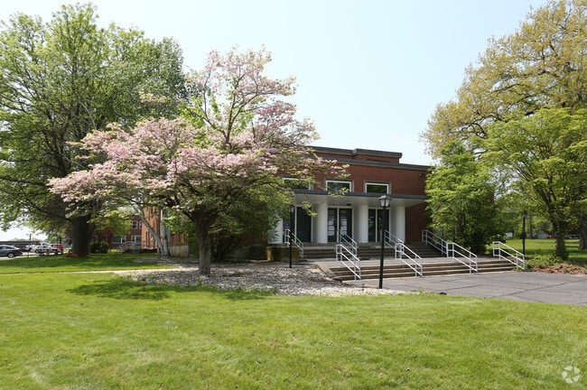

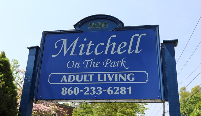
Property Detail
226 Prospect St
Apartmenthouse5plusunits
HARTFORD
SRD
Connecticut
B and X Area of moderate flood hazard, usually the area between the limits of the 100-year and 500-year floods.
2.95 AC
2025
New Britain/Newington/Wethersfield
2025
Hartford
492600
Hartford-West Hartford-East Hartford, CT
60,973 SF
179 077
NEARBY LISTINGS FOR SALE OR LEASE
-
-
No Photo
-
View all Wethersfield listings for sale on LoopNet.com
DEMOGRAPHICS near 226 Prospect St
1 mile
3 mile
5 mile
2025 Total Population
9,261
57,999
199,940
2030 Population
9,419
58,878
203,182
Pop Growth 2025-2030
+ 1.71%
+ 1.52%
+ 1.62%
Average Age
43
43
40
2025 Total Households
3,920
23,802
80,065
HH Growth 2025-2030
+ 1.86%
+ 1.60%
+ 1.75%
Median Household Inc
$117,459
$102,894
$80,721
Avg Household Size
2.30
2.40
2.40
2025 Avg HH Vehicles
2.00
2.00
2.00
Median Home Value
$328,514
$324,712
$300,580
Median Year Built
1957
1962
1960
Nearby Places
Map Layers
Map Styles
 Street
 Aerial
Transit
 Traffic
 Biking
Places
Listings with unknown addresses are not visible on the map
- Restaurants
- Banks
- Shops
- Fitness
- Groceries
PUBLIC TRANSPORTATION
COMMUTER RAIL
Hartford (Hartford Line - CONN DOT)
Drive
Walk
Distance
Hartford (Hartford Line - CONN DOT)
11 min
7.1 mi
Hartford Amtrak Station (Amtrak Hartford Line - Amtrak, Northeast Regional - Amtrak, Valley Flyer - Amtrak, Vermonter - Amtrak)
Drive
Walk
Distance
Hartford Amtrak Station (Amtrak Hartford Line - Amtrak, Northeast Regional - Amtrak, Valley Flyer - Amtrak, Vermonter - Amtrak)
12 min
7.1 mi
AIRPORT
Bradley International
Drive
Walk
Distance
Bradley International
40 min
23.3 mi
Freight Ports
Port of New Haven
Drive
Walk
Distance
Port of New Haven
46 min
33.8 mi
Nearby Properties
Address
Land Use
TOTAL SIZE
Lot Size
Zoning
Address
Land Use
TOTAL SIZE
Lot Size
Zoning
261,072 SF
44.47 AC
PL
Address
Land Use
TOTAL SIZE
Lot Size
Zoning
81,507 SF
21.60 AC
R-20
Address
Land Use
TOTAL SIZE
Lot Size
Zoning
54.95 AC
PDR
Address
Land Use
TOTAL SIZE
Lot Size
Zoning
33.30 AC
R-20
Address
Land Use
TOTAL SIZE
Lot Size
Zoning
254,786 SF
36 AC
A
Address
Land Use
TOTAL SIZE
Lot Size
Zoning
3,416 SF
19.31 AC
SRD
Address
Land Use
TOTAL SIZE
Lot Size
Zoning
126.75 AC
OS
Address
Land Use
TOTAL SIZE
Lot Size
Zoning
116,979 SF
17 AC
B
Address
Land Use
TOTAL SIZE
Lot Size
Zoning
9.09 AC
R-20
Address
Land Use
TOTAL SIZE
Lot Size
Zoning
188,427 SF
8.55 AC
SRD
Address
Land Use
TOTAL SIZE
Lot Size
Zoning
129,065 SF
4.63 AC
MX-2
Address
Land Use
TOTAL SIZE
Lot Size
Zoning
68,967 SF
11.25 AC
O
Address
Land Use
TOTAL SIZE
Lot Size
Zoning
10.45 AC
R-20
Address
Land Use
TOTAL SIZE
Lot Size
Zoning
83,468 SF
6.65 AC
R-20
Address
Land Use
TOTAL SIZE
Lot Size
Zoning
Address
Land Use
TOTAL SIZE
Lot Size
Zoning
53.52 AC
PL
Address
Land Use
TOTAL SIZE
Lot Size
Zoning
13.61 AC
RC
Address
Land Use
TOTAL SIZE
Lot Size
Zoning
8.56 AC
TC
Address
Land Use
TOTAL SIZE
Lot Size
Zoning
186,777 SF
21.25 AC
RC
Address
Land Use
TOTAL SIZE
Lot Size
Zoning
38.84 AC
RC
Address
Land Use
TOTAL SIZE
Lot Size
Zoning
75,478 SF
14.40 AC
A1
Address
Land Use
TOTAL SIZE
Lot Size
Zoning
175,694 SF
9.03 AC
BP
Address
Land Use
TOTAL SIZE
Lot Size
Zoning
97.02 AC
A1
Address
Land Use
TOTAL SIZE
Lot Size
Zoning
57,862 SF
23.20 AC
AA
Address
Land Use
TOTAL SIZE
Lot Size
Zoning
68,601 SF
5.36 AC
SRD
Address
Land Use
TOTAL SIZE
Lot Size
Zoning
135,562 SF
3.15 AC
RC
Address
Land Use
TOTAL SIZE
Lot Size
Zoning
128,075 SF
6.05 AC
MX-2
Address
Land Use
TOTAL SIZE
Lot Size
Zoning
14.11 AC
C
Address
Land Use
TOTAL SIZE
Lot Size
Zoning
11.80 AC
R-20
Address
Land Use
TOTAL SIZE
Lot Size
Zoning
148,586 SF
9.30 AC
O
The World's #1 Commercial Real Estate Marketplace
Connect with us
© 2026 CoStar Group
The information above has been obtained from sources believed reliable. While we do not doubt its accuracy we have not verified it and make no guarantee, warranty or representation about it. It is your responsibility to independently confirm its accuracy and completeness. Any projections, opinions, assumptions, or estimates used are for example only and do not represent the current or future performance of the property. The value of this transaction to you depends on tax and other factors which should be evaluated by your tax, financial, and legal advisors. You and your advisors should conduct a careful, independent investigation of the property to determine to your satisfaction the suitability of the property for your needs.