No Photo
Property Record
226 W 27Th St, Northampton, PA 18067


Current Lease Availabilities
NEARBY LISTINGS FOR SALE OR LEASE
Property Detail
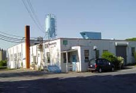
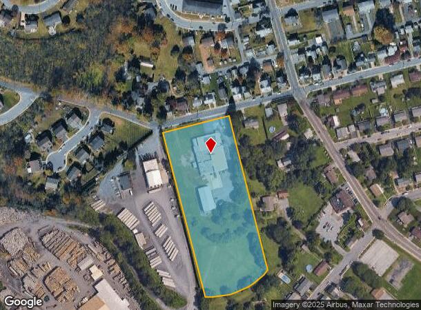
226 W 27Th St
Manufacturinglight
Northampton
X
Pennsylvania
42095C0209E
5.25 AC
2025
Lehigh Valley
2025
Philadelphia
016201
Allentown-Bethlehem-Easton, PA-NJ
20,171 SF
L4-7-1-0522
DEMOGRAPHICS near 226 W 27Th St
1 Mile
3 Mile
5 Mile
2024 Total Population
5,210
33,398
68,708
2029 Population
5,261
33,595
69,106
Pop Growth 2024-2029
+ 0.98%
+ 0.59%
+ 0.58%
Average Age
43
42
43
2024 Total Households
2,138
13,502
27,459
HH Growth 2024-2029
+ 1.03%
+ 0.62%
+ 0.58%
Median Household Inc
$76,553
$76,685
$74,121
Avg Household Size
2.30
2.40
2.50
2024 Avg HH Vehicles
2.00
2.00
2.00
Median Home Value
$197,070
$237,756
$242,891
Median Year Built
1969
1970
1970
Nearby Places
- Restaurants
- Banks
- Shops
- Fitness
- Groceries
PUBLIC TRANSPORTATION
AIRPORT
Lehigh Valley International
DRIVE
WALK
Distance
Lehigh Valley International
13 min
6.4 mi
Freight Ports
Port of Philadelphia
DRIVE
WALK
Distance
Port of Philadelphia
93 min
69.5 mi
Nearby Properties
Address
Land Use
TOTAL SIZE
Lot Size
Zoning
Address
Land Use
TOTAL SIZE
Lot Size
Zoning
956,444 SF
I
Address
Land Use
TOTAL SIZE
Lot Size
Zoning
504,475 SF
39.36 AC
I
Address
Land Use
TOTAL SIZE
Lot Size
Zoning
85.20 AC
I2
Address
Land Use
TOTAL SIZE
Lot Size
Zoning
605,893 SF
I
Address
Land Use
TOTAL SIZE
Lot Size
Zoning
45,176 SF
11.04 AC
R-4
Address
Land Use
TOTAL SIZE
Lot Size
Zoning
105,219 SF
47.10 AC
RA
Address
Land Use
TOTAL SIZE
Lot Size
Zoning
164,816 SF
48.85 AC
R1
Address
Land Use
TOTAL SIZE
Lot Size
Zoning
316,786 SF
29.22 AC
I2
Address
Land Use
TOTAL SIZE
Lot Size
Zoning
24,878 SF
20.66 AC
AR
Address
Land Use
TOTAL SIZE
Lot Size
Zoning
262,476 SF
30.77 AC
I2
Address
Land Use
TOTAL SIZE
Lot Size
Zoning
65,524 SF
22.48 AC
I
Address
Land Use
TOTAL SIZE
Lot Size
Zoning
3,522 SF
20.74 AC
R3
Address
Land Use
TOTAL SIZE
Lot Size
Zoning
55,048 SF
12.47 AC
C-2A
Address
Land Use
TOTAL SIZE
Lot Size
Zoning
11,040 SF
4.18 AC
C-1
Address
Land Use
TOTAL SIZE
Lot Size
Zoning
301,097 SF
14.19 AC
I
Address
Land Use
TOTAL SIZE
Lot Size
Zoning
56,720 SF
4.17 AC
C-1
Address
Land Use
TOTAL SIZE
Lot Size
Zoning
8,280 SF
4.20 AC
R-5
Address
Land Use
TOTAL SIZE
Lot Size
Zoning
27,128 SF
1.70 AC
C
Address
Land Use
TOTAL SIZE
Lot Size
Zoning
15,750 SF
5.10 AC
R-6
Address
Land Use
TOTAL SIZE
Lot Size
Zoning
6,799 SF
2.82 AC
R-5
Address
Land Use
TOTAL SIZE
Lot Size
Zoning
9,068 SF
6.10 AC
R-4
Address
Land Use
TOTAL SIZE
Lot Size
Zoning
1,920 SF
26.19 AC
VR
Address
Land Use
TOTAL SIZE
Lot Size
Zoning
15,789 SF
8.78 AC
R-4
Address
Land Use
TOTAL SIZE
Lot Size
Zoning
1,815 SF
29.80 AC
R-6
Address
Land Use
TOTAL SIZE
Lot Size
Zoning
2,339 SF
202.96 AC
OS-2
Address
Land Use
TOTAL SIZE
Lot Size
Zoning
79.14 AC
OS-2
Address
Land Use
TOTAL SIZE
Lot Size
Zoning
44,041 SF
1.21 AC
R-5A
Address
Land Use
TOTAL SIZE
Lot Size
Zoning
12,376 SF
4.04 AC
R-5A
Address
Land Use
TOTAL SIZE
Lot Size
Zoning
8,280 SF
2.29 AC
R-5
Address
Land Use
TOTAL SIZE
Lot Size
Zoning
48,109 SF
4.19 AC
I
The World's #1 Commercial Real Estate Marketplace
Connect with us
© 2025 CoStar Group
The information above has been obtained from sources believed reliable. While we do not doubt its accuracy we have not verified it and make no guarantee, warranty or representation about it. It is your responsibility to independently confirm its accuracy and completeness. Any projections, opinions, assumptions, or estimates used are for example only and do not represent the current or future performance of the property. The value of this transaction to you depends on tax and other factors which should be evaluated by your tax, financial, and legal advisors. You and your advisors should conduct a careful, independent investigation of the property to determine to your satisfaction the suitability of the property for your needs.