Property Record
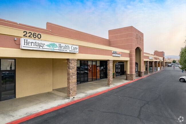
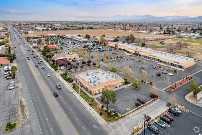
2260 E Palmdale Blvd, Palmdale, CA 93550

Property Detail
2260 E Palmdale Blvd
3018-028-055
THAT POR IN TRA 7596 OF SW 1/4 OF SEC 30 T 6N R 11W
Regionalshoppingcenterormallwithanchorstore
Los Angeles
PDC3
California
C and X Area of minimal flood hazard, usually depicted on FIRMs as above the 500-year flood level.
8.69 AC
2024
Antelope Valley
2025
Los Angeles
910602
Los Angeles-Long Beach-Glendale, CA
53,456 SF
NEARBY LISTINGS FOR SALE OR LEASE
DEMOGRAPHICS near 2260 E Palmdale Blvd
1 mile
3 mile
5 mile
2025 Total Population
15,952
97,745
144,259
2030 Population
15,714
97,519
143,512
Pop Growth 2025-2030
(1.49%)
(0.23%)
(0.52%)
Average Age
36
36
36
2025 Total Households
4,555
27,949
40,634
HH Growth 2025-2030
(1.67%)
(0.21%)
(0.57%)
Median Household Inc
$62,064
$65,427
$73,818
Avg Household Size
3.40
3.40
3.50
2025 Avg HH Vehicles
2.00
2.00
2.00
Median Home Value
$342,393
$388,343
$429,978
Median Year Built
1981
1985
1987
Nearby Places
Map Layers
Map Styles
 Street
 Aerial
Layers
 Traffic
 Biking
Places
Listings with unknown addresses are not visible on the map
- Restaurants
- Banks
- Shops
- Fitness
- Groceries
PUBLIC TRANSPORTATION
COMMUTER RAIL
Palmdale (Antelope Valley Line - Southern California Regional Rail Authority (Metrolink))
Drive
Walk
Distance
Palmdale (Antelope Valley Line - Southern California Regional Rail Authority (Metrolink))
5 min
2.6 mi
Vincent Grade/Acton (Antelope Valley Line - Southern California Regional Rail Authority (Metrolink))
Drive
Walk
Distance
Vincent Grade/Acton (Antelope Valley Line - Southern California Regional Rail Authority (Metrolink))
14 min
7.0 mi
AIRPORT
Bob Hope
Drive
Walk
Distance
Bob Hope
60 min
49.0 mi
SALE & LEASE HISTORY
LISTING DATE
SALE/LEASE

Jan 04, 2019
For Lease
Nearby Properties
Address
Land Use
TOTAL SIZE
Lot Size
Zoning
Address
Land Use
TOTAL SIZE
Lot Size
Zoning
2,861,890 SF
528.69 AC
POMA-A25*
Address
Land Use
TOTAL SIZE
Lot Size
Zoning
167,366 SF
15.36 AC
PDC3
Address
Land Use
TOTAL SIZE
Lot Size
Zoning
172,894 SF
14.26 AC
PDC3*
Address
Land Use
TOTAL SIZE
Lot Size
Zoning
101,172 SF
10.22 AC
PDR1*
Address
Land Use
TOTAL SIZE
Lot Size
Zoning
221,827 SF
14.90 AC
PDRPD10U-R
Address
Land Use
TOTAL SIZE
Lot Size
Zoning
157,021 SF
PDRN4
Address
Land Use
TOTAL SIZE
Lot Size
Zoning
209,328 SF
6.35 AC
PDC3-RPD15
Address
Land Use
TOTAL SIZE
Lot Size
Zoning
71,394 SF
2.93 AC
PDCPD*
Address
Land Use
TOTAL SIZE
Lot Size
Zoning
76,609 SF
3.61 AC
PDM2
Address
Land Use
TOTAL SIZE
Lot Size
Zoning
2,908,124 SF
126.15 AC
LCM21/2*
Address
Land Use
TOTAL SIZE
Lot Size
Zoning
80,981 SF
7.11 AC
PDC3
Address
Land Use
TOTAL SIZE
Lot Size
Zoning
55,079 SF
1.98 AC
PDCPD*
Address
Land Use
TOTAL SIZE
Lot Size
Zoning
71,974 SF
3.83 AC
PDCPD*
Address
Land Use
TOTAL SIZE
Lot Size
Zoning
81,790 SF
5.70 AC
PDR1*
Address
Land Use
TOTAL SIZE
Lot Size
Zoning
78,176 SF
6.11 AC
PDR1*
Address
Land Use
TOTAL SIZE
Lot Size
Zoning
108,762 SF
4.22 AC
PDR3
Address
Land Use
TOTAL SIZE
Lot Size
Zoning
81,512 SF
4.25 AC
PDR1*
Address
Land Use
TOTAL SIZE
Lot Size
Zoning
67,560 SF
5.12 AC
PDR1*
Address
Land Use
TOTAL SIZE
Lot Size
Zoning
63,944 SF
2.33 AC
PDR1-7000
Address
Land Use
TOTAL SIZE
Lot Size
Zoning
171,078 SF
10.26 AC
PDR3DP*
Address
Land Use
TOTAL SIZE
Lot Size
Zoning
43,898 SF
4 AC
PDR1*
Address
Land Use
TOTAL SIZE
Lot Size
Zoning
47,826 SF
5.92 AC
PDC3*
Address
Land Use
TOTAL SIZE
Lot Size
Zoning
153,879 SF
12.37 AC
PDR3*
Address
Land Use
TOTAL SIZE
Lot Size
Zoning
106,048 SF
9.82 AC
PDR3*
Address
Land Use
TOTAL SIZE
Lot Size
Zoning
225,054 SF
PDC3
Address
Land Use
TOTAL SIZE
Lot Size
Zoning
154,988 SF
PDR3*
Address
Land Use
TOTAL SIZE
Lot Size
Zoning
85,392 SF
4.36 AC
PDR3*
Address
Land Use
TOTAL SIZE
Lot Size
Zoning
111,132 SF
6.53 AC
PDR3DP-R3*
Address
Land Use
TOTAL SIZE
Lot Size
Zoning
53,896 SF
6.45 AC
PDC3
Address
Land Use
TOTAL SIZE
Lot Size
Zoning
38,493 SF
3.23 AC
PDR1*
The World's #1 Commercial Real Estate Marketplace
Connect with us
© 2026 CoStar Group
The information above has been obtained from sources believed reliable. While we do not doubt its accuracy we have not verified it and make no guarantee, warranty or representation about it. It is your responsibility to independently confirm its accuracy and completeness. Any projections, opinions, assumptions, or estimates used are for example only and do not represent the current or future performance of the property. The value of this transaction to you depends on tax and other factors which should be evaluated by your tax, financial, and legal advisors. You and your advisors should conduct a careful, independent investigation of the property to determine to your satisfaction the suitability of the property for your needs.