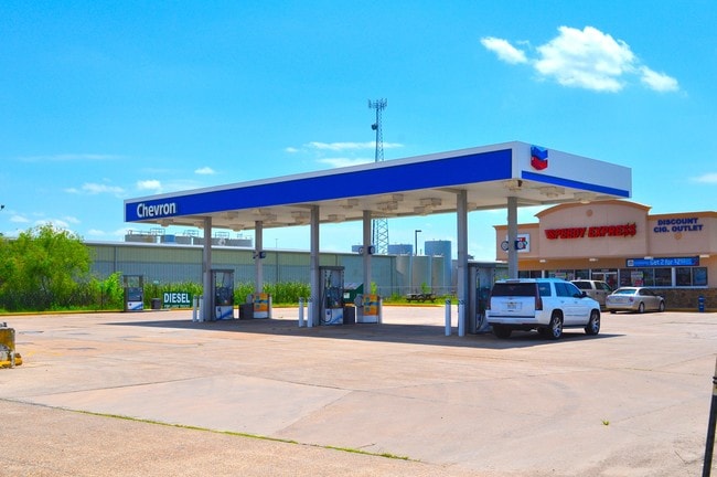
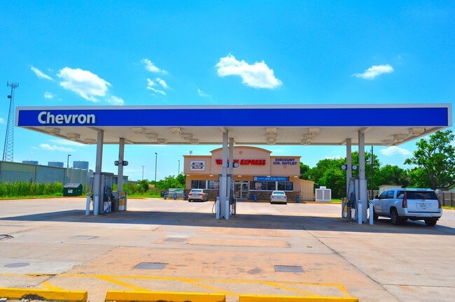
Property Record
22602 N Highway 288B, Angleton, TX 77515

Save to a Folder
{{folder.Name}}
{{folder.ListingIds.length}} Properties
{{folder.ListingIds.length}} Property
Create a New Folder
Property Detail
22602 N Highway 288B
Houston-Pasadena-The Woodlands, TX
A0144 J ABBOTT TRACT C1A1-C1A2 ACRES 1.394
0144-0023-110
Brazoria
Commercialnec
Texas
B and X Area of moderate flood hazard, usually the area between the limits of the 100-year and 500-year floods.
c1a1
2024
1.39 AC
2025
Far South
661901
Houston
2,640 SF
NEARBY LISTINGS FOR SALE OR LEASE
-
-
View all Angleton listings for sale on LoopNet.com
DEMOGRAPHICS near 22602 N Highway 288B
1 mile
3 mile
5 mile
2025 Total Population
305
1,867
10,494
2030 Population
342
2,078
11,445
Pop Growth 2025-2030
+ 12.13%
+ 11.30%
+ 9.06%
Average Age
39
41
44
2025 Total Households
79
460
2,181
HH Growth 2025-2030
+ 13.92%
+ 13.26%
+ 11.65%
Median Household Inc
$95,192
$92,788
$86,779
Avg Household Size
2.90
2.90
2.80
2025 Avg HH Vehicles
2.00
2.00
2.00
Median Home Value
$374,999
$350,909
$279,442
Median Year Built
2000
1999
1995
Nearby Places
Map Layers
Map Styles
 Street
 Aerial
Layers
 Traffic
 Biking
Places
Listings with unknown addresses are not visible on the map
- Restaurants
- Banks
- Shops
- Fitness
- Groceries
PUBLIC TRANSPORTATION
AIRPORT
William P Hobby
Drive
Walk
Distance
William P Hobby
49 min
34.1 mi
SALE & LEASE HISTORY
LISTING DATE
SALE/LEASE

Aug 14, 2017
For Sale
Nearby Properties
Address
Land Use
TOTAL SIZE
Lot Size
Zoning
Address
Land Use
TOTAL SIZE
Lot Size
Zoning
Address
Land Use
TOTAL SIZE
Lot Size
Zoning
Address
Land Use
TOTAL SIZE
Lot Size
Zoning
336 SF
26.79 AC
0040
Address
Land Use
TOTAL SIZE
Lot Size
Zoning
63,810 SF
3.85 AC
Address
Land Use
TOTAL SIZE
Lot Size
Zoning
74,700 SF
15.46 AC
0007
Address
Land Use
TOTAL SIZE
Lot Size
Zoning
111,638 SF
363.32 AC
0035
Address
Land Use
TOTAL SIZE
Lot Size
Zoning
21,409 SF
206.75 AC
0005
Address
Land Use
TOTAL SIZE
Lot Size
Zoning
22,062 SF
10.13 AC
Address
Land Use
TOTAL SIZE
Lot Size
Zoning
32,980 SF
10.98 AC
Address
Land Use
TOTAL SIZE
Lot Size
Zoning
129.90 AC
0002
Address
Land Use
TOTAL SIZE
Lot Size
Zoning
25,200 SF
449.75 AC
0056
Address
Land Use
TOTAL SIZE
Lot Size
Zoning
76.70 AC
Address
Land Use
TOTAL SIZE
Lot Size
Zoning
7,000 SF
8.25 AC
Address
Land Use
TOTAL SIZE
Lot Size
Zoning
39.99 AC
0003
Address
Land Use
TOTAL SIZE
Lot Size
Zoning
86,370 SF
31.09 AC
0047
Address
Land Use
TOTAL SIZE
Lot Size
Zoning
37,560 SF
4.49 AC
Address
Land Use
TOTAL SIZE
Lot Size
Zoning
1,256.37 AC
0017
Address
Land Use
TOTAL SIZE
Lot Size
Zoning
162.61 AC
Address
Land Use
TOTAL SIZE
Lot Size
Zoning
18,150 SF
9.96 AC
0222
Address
Land Use
TOTAL SIZE
Lot Size
Zoning
10,100 SF
9.54 AC
Address
Land Use
TOTAL SIZE
Lot Size
Zoning
43,900 SF
13.96 AC
Address
Land Use
TOTAL SIZE
Lot Size
Zoning
50.35 AC
0046
Address
Land Use
TOTAL SIZE
Lot Size
Zoning
208.06 AC
0039
Address
Land Use
TOTAL SIZE
Lot Size
Zoning
30,614 SF
38.32 AC
0014
Address
Land Use
TOTAL SIZE
Lot Size
Zoning
Address
Land Use
TOTAL SIZE
Lot Size
Zoning
12.72 AC
Address
Land Use
TOTAL SIZE
Lot Size
Zoning
24.24 AC
0036
Address
Land Use
TOTAL SIZE
Lot Size
Zoning
11,492 SF
11 AC
0036
Address
Land Use
TOTAL SIZE
Lot Size
Zoning
39.32 AC
Address
Land Use
TOTAL SIZE
Lot Size
Zoning
10,912 SF
135.07 AC
The World's #1 Commercial Real Estate Marketplace
Connect with us
© 2026 CoStar Group
The information above has been obtained from sources believed reliable. While we do not doubt its accuracy we have not verified it and make no guarantee, warranty or representation about it. It is your responsibility to independently confirm its accuracy and completeness. Any projections, opinions, assumptions, or estimates used are for example only and do not represent the current or future performance of the property. The value of this transaction to you depends on tax and other factors which should be evaluated by your tax, financial, and legal advisors. You and your advisors should conduct a careful, independent investigation of the property to determine to your satisfaction the suitability of the property for your needs.