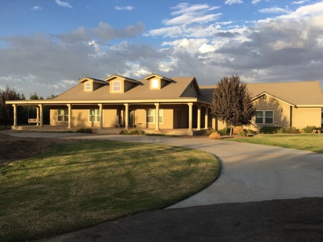
Property Record
22608 Road 180, Lindsay, CA 93247


NEARBY LISTINGS FOR SALE OR LEASE
-
-
View all Lindsay listings for sale on LoopNet.com
Property Detail
22608 Road 180
197-080-013-000
POR SW/4 OF 9-20-26
Orchard
Tulare
X
California
06107C1300E
32.33 AC
2024
SW Outlying Tulare County
2025
Visalia/Porterville
002500
Visalia-Porterville, CA
DEMOGRAPHICS near 22608 Road 180
1 Mile
3 Mile
5 Mile
2024 Total Population
107
760
15,370
2029 Population
110
779
15,794
Pop Growth 2024-2029
+ 2.80%
+ 2.50%
+ 2.76%
Average Age
36
36
33
2024 Total Households
32
223
4,273
HH Growth 2024-2029
0.00%
+ 2.24%
+ 2.74%
Median Household Inc
$55,000
$53,485
$42,965
Avg Household Size
3.30
3.20
3.60
2024 Avg HH Vehicles
2.00
2.00
2.00
Median Home Value
$363,636
$361,111
$243,393
Median Year Built
1980
1979
1977
Nearby Places
Map Layers
Map Styles
 Street
 Aerial
- Restaurants
- Banks
- Shops
- Fitness
- Groceries
SALE & LEASE HISTORY
LISTING DATE
SALE/LEASE

Mar 14, 2019
For Sale
Nearby Properties
Address
Land Use
TOTAL SIZE
Lot Size
Zoning
Address
Land Use
TOTAL SIZE
Lot Size
Zoning
160 AC
AE40
Address
Land Use
TOTAL SIZE
Lot Size
Zoning
159.28 AC
AE40
Address
Land Use
TOTAL SIZE
Lot Size
Zoning
5,140 SF
160 AC
AE40
Address
Land Use
TOTAL SIZE
Lot Size
Zoning
5,035 SF
54.43 AC
AE40
Address
Land Use
TOTAL SIZE
Lot Size
Zoning
3,810 SF
1.05 AC
C1
Address
Land Use
TOTAL SIZE
Lot Size
Zoning
3,588 SF
133 AC
AE40
Address
Land Use
TOTAL SIZE
Lot Size
Zoning
74,880 SF
10 AC
M2
Address
Land Use
TOTAL SIZE
Lot Size
Zoning
5,227 SF
18.88 AC
AE40
Address
Land Use
TOTAL SIZE
Lot Size
Zoning
157.57 AC
AE40
Address
Land Use
TOTAL SIZE
Lot Size
Zoning
10 AC
AE10
Address
Land Use
TOTAL SIZE
Lot Size
Zoning
160.80 AC
AE40
Address
Land Use
TOTAL SIZE
Lot Size
Zoning
154.54 AC
AE40
Address
Land Use
TOTAL SIZE
Lot Size
Zoning
64 AC
AE40
Address
Land Use
TOTAL SIZE
Lot Size
Zoning
2,032 SF
84.54 AC
AE-40
Address
Land Use
TOTAL SIZE
Lot Size
Zoning
10,625 SF
9.72 AC
AE-10
Address
Land Use
TOTAL SIZE
Lot Size
Zoning
156.96 AC
AE40
Address
Land Use
TOTAL SIZE
Lot Size
Zoning
20 AC
AE40
Address
Land Use
TOTAL SIZE
Lot Size
Zoning
3,657 SF
16.25 AC
AE10
Address
Land Use
TOTAL SIZE
Lot Size
Zoning
78.48 AC
AE40
Address
Land Use
TOTAL SIZE
Lot Size
Zoning
3,600 SF
18.02 AC
AE20
Address
Land Use
TOTAL SIZE
Lot Size
Zoning
2,232 SF
139.11 AC
AE40
Address
Land Use
TOTAL SIZE
Lot Size
Zoning
2,657 SF
78.10 AC
AE40
Address
Land Use
TOTAL SIZE
Lot Size
Zoning
1,054 SF
19.12 AC
AE40
Address
Land Use
TOTAL SIZE
Lot Size
Zoning
29.41 AC
AE40
Address
Land Use
TOTAL SIZE
Lot Size
Zoning
2,387 SF
20 AC
AE40
Address
Land Use
TOTAL SIZE
Lot Size
Zoning
2,481 SF
5.01 AC
AE40
Address
Land Use
TOTAL SIZE
Lot Size
Zoning
2,792 SF
3.13 AC
AE20
Address
Land Use
TOTAL SIZE
Lot Size
Zoning
3,278 SF
8.82 AC
AE10
Address
Land Use
TOTAL SIZE
Lot Size
Zoning
1,299 SF
48.19 AC
AE20
The World's #1 Commercial Real Estate Marketplace
Connect with us
© 2025 CoStar Group
The information above has been obtained from sources believed reliable. While we do not doubt its accuracy we have not verified it and make no guarantee, warranty or representation about it. It is your responsibility to independently confirm its accuracy and completeness. Any projections, opinions, assumptions, or estimates used are for example only and do not represent the current or future performance of the property. The value of this transaction to you depends on tax and other factors which should be evaluated by your tax, financial, and legal advisors. You and your advisors should conduct a careful, independent investigation of the property to determine to your satisfaction the suitability of the property for your needs.