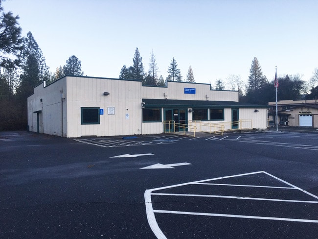
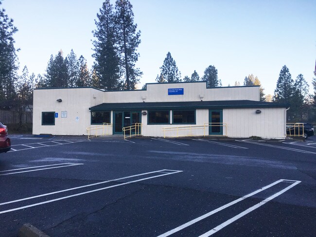
Property Record
22628 Parrotts Ferry Rd, Columbia, CA 95310

Property Detail
22628 Parrotts Ferry Rd
037-280-018-000
PAR 1 PM 7-65 POR BLK 4 COLUMBIA .68AC
Commercialnec
Tuolumne
C-O,D,AIR
California
B and X Area of moderate flood hazard, usually the area between the limits of the 100-year and 500-year floods.
0.68 AC
2024
Merced/Central
2025
Other Market Areas
002101
Sonora, CA
4,105 SF
NEARBY LISTINGS FOR SALE OR LEASE
-
-
View all Columbia listings for sale on LoopNet.com
DEMOGRAPHICS near 22628 Parrotts Ferry Rd
1 mile
3 mile
5 mile
2025 Total Population
1,749
5,506
14,707
2030 Population
1,677
5,238
14,033
Pop Growth 2025-2030
(4.12%)
(4.87%)
(4.58%)
Average Age
44
45
46
2025 Total Households
763
2,350
6,452
HH Growth 2025-2030
(4.46%)
(5.28%)
(4.99%)
Median Household Inc
$59,650
$71,999
$82,992
Avg Household Size
2.20
2.30
2.20
2025 Avg HH Vehicles
2.00
2.00
2.00
Median Home Value
$402,632
$442,506
$456,709
Median Year Built
1984
1978
1978
Nearby Places
Map Layers
Map Styles
 Street
 Aerial
Layers
 Traffic
 Biking
Places
Listings with unknown addresses are not visible on the map
- Restaurants
- Banks
- Shops
- Fitness
- Groceries
SALE & LEASE HISTORY
LISTING DATE
SALE/LEASE

Jan 15, 2019
For Sale
Nearby Properties
Address
Land Use
TOTAL SIZE
Lot Size
Zoning
Address
Land Use
TOTAL SIZE
Lot Size
Zoning
168 SF
117.44 AC
AE-37
Address
Land Use
TOTAL SIZE
Lot Size
Zoning
106,879 SF
8.10 AC
R-3,D,MX
Address
Land Use
TOTAL SIZE
Lot Size
Zoning
2,498 SF
0.75 AC
PD
Address
Land Use
TOTAL SIZE
Lot Size
Zoning
9,100 SF
0.80 AC
Address
Land Use
TOTAL SIZE
Lot Size
Zoning
600 SF
3.18 AC
C-1,AIR
Address
Land Use
TOTAL SIZE
Lot Size
Zoning
4,522 SF
2.32 AC
C-1,D,MX
Address
Land Use
TOTAL SIZE
Lot Size
Zoning
21,800 SF
1.74 AC
C-1,D,PD
Address
Land Use
TOTAL SIZE
Lot Size
Zoning
8,824 SF
0.80 AC
C-O,D,AIR
Address
Land Use
TOTAL SIZE
Lot Size
Zoning
2.71 AC
R-2,AIR
Address
Land Use
TOTAL SIZE
Lot Size
Zoning
7,020 SF
0.68 AC
R-1,D,H,MX
Address
Land Use
TOTAL SIZE
Lot Size
Zoning
5,505 SF
160.33 AC
AE-37,MX
Address
Land Use
TOTAL SIZE
Lot Size
Zoning
4,432 SF
82.64 AC
RE-5,MX
Address
Land Use
TOTAL SIZE
Lot Size
Zoning
1,510 SF
0.72 AC
C-1,D,PD
Address
Land Use
TOTAL SIZE
Lot Size
Zoning
10,672 SF
1.56 AC
PD
Address
Land Use
TOTAL SIZE
Lot Size
Zoning
4,479 SF
18.26 AC
A-20,MX
Address
Land Use
TOTAL SIZE
Lot Size
Zoning
6,178 SF
5.68 AC
RE-5,AIR
Address
Land Use
TOTAL SIZE
Lot Size
Zoning
2.94 AC
R-3,D,AIR
Address
Land Use
TOTAL SIZE
Lot Size
Zoning
14.47 AC
M-U,PD,MX
Address
Land Use
TOTAL SIZE
Lot Size
Zoning
4,161 SF
10.26 AC
A-20,PD
Address
Land Use
TOTAL SIZE
Lot Size
Zoning
2,822 SF
46.34 AC
RE-10 & O
Address
Land Use
TOTAL SIZE
Lot Size
Zoning
2,924 SF
4.42 AC
Address
Land Use
TOTAL SIZE
Lot Size
Zoning
4,157 SF
16.73 AC
A-10,AIR
Address
Land Use
TOTAL SIZE
Lot Size
Zoning
3.37 AC
C-1,D,AIR
Address
Land Use
TOTAL SIZE
Lot Size
Zoning
1,916 SF
6.52 AC
RE-5,AIR
Address
Land Use
TOTAL SIZE
Lot Size
Zoning
1,632 SF
1.64 AC
M-U,D,AIR
Address
Land Use
TOTAL SIZE
Lot Size
Zoning
2,897 SF
15.86 AC
A-10
Address
Land Use
TOTAL SIZE
Lot Size
Zoning
3,750 SF
3.25 AC
C-1 & O
Address
Land Use
TOTAL SIZE
Lot Size
Zoning
4,267 SF
10 AC
A-10,MX
Address
Land Use
TOTAL SIZE
Lot Size
Zoning
5,108 SF
2.19 AC
R-3,RE
The World's #1 Commercial Real Estate Marketplace
Connect with us
© 2026 CoStar Group
The information above has been obtained from sources believed reliable. While we do not doubt its accuracy we have not verified it and make no guarantee, warranty or representation about it. It is your responsibility to independently confirm its accuracy and completeness. Any projections, opinions, assumptions, or estimates used are for example only and do not represent the current or future performance of the property. The value of this transaction to you depends on tax and other factors which should be evaluated by your tax, financial, and legal advisors. You and your advisors should conduct a careful, independent investigation of the property to determine to your satisfaction the suitability of the property for your needs.