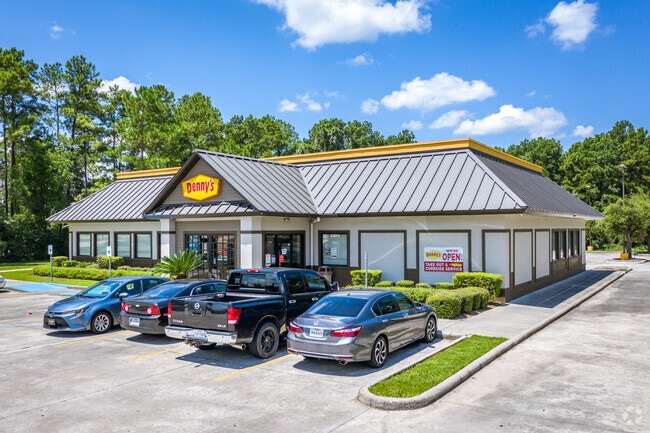
Property Record
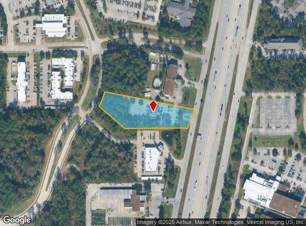
22671 Us Highway 59, New Caney, TX 77357
NEARBY LISTINGS FOR SALE OR LEASE
Property Detail
22671 Us Highway 59
6433-21-00215
Kingwood Place 21
Commercialnec
KINGWOOD PLACE 21, BLOCK RESERVE B-3, ACRES 2.391
X
Montgomery
48339C0725G
Texas
2024
2.39 AC
2025
Montgomery County
692802
Houston
5,210 SF
Houston-The Woodlands-Sugar Land, TX
DEMOGRAPHICS near 22671 Us Highway 59
1 Mile
3 Mile
5 Mile
2024 Total Population
4,874
42,516
135,956
2029 Population
5,660
47,990
147,574
Pop Growth 2024-2029
+ 16.13%
+ 12.88%
+ 8.55%
Average Age
39
39
37
2024 Total Households
2,180
16,565
48,657
HH Growth 2024-2029
+ 17.94%
+ 13.87%
+ 8.98%
Median Household Inc
$55,325
$75,145
$74,872
Avg Household Size
2.20
2.50
2.70
2024 Avg HH Vehicles
1.00
2.00
2.00
Median Home Value
$252,575
$253,188
$226,751
Median Year Built
2005
2001
1995
Nearby Places
Map Layers
Map Styles
 Street
 Aerial
- Restaurants
- Banks
- Shops
- Fitness
- Groceries
PUBLIC TRANSPORTATION
AIRPORT
George Bush Intcntl/Houston
DRIVE
WALK
Distance
George Bush Intcntl/Houston
17 min
11.6 mi
William P Hobby
DRIVE
WALK
Distance
William P Hobby
49 min
33.2 mi
Freight Ports
Port of Houston
DRIVE
WALK
Distance
Port of Houston
38 min
26.9 mi
Nearby Properties
Address
Land Use
TOTAL SIZE
Lot Size
Zoning
Address
Land Use
TOTAL SIZE
Lot Size
Zoning
687,195 SF
33.75 AC
Address
Land Use
TOTAL SIZE
Lot Size
Zoning
633,347 SF
32.15 AC
5
Address
Land Use
TOTAL SIZE
Lot Size
Zoning
733,100 SF
28.18 AC
Address
Land Use
TOTAL SIZE
Lot Size
Zoning
604,908 SF
58.67 AC
Address
Land Use
TOTAL SIZE
Lot Size
Zoning
363,730 SF
12.59 AC
Address
Land Use
TOTAL SIZE
Lot Size
Zoning
275,500 SF
13.58 AC
Address
Land Use
TOTAL SIZE
Lot Size
Zoning
407,266 SF
25.02 AC
Address
Land Use
TOTAL SIZE
Lot Size
Zoning
288,199 SF
15.50 AC
Address
Land Use
TOTAL SIZE
Lot Size
Zoning
392,395 SF
14.86 AC
5
Address
Land Use
TOTAL SIZE
Lot Size
Zoning
316,815 SF
15.61 AC
Address
Land Use
TOTAL SIZE
Lot Size
Zoning
341,175 SF
65.76 AC
5
Address
Land Use
TOTAL SIZE
Lot Size
Zoning
327,725 SF
22.04 AC
5
Address
Land Use
TOTAL SIZE
Lot Size
Zoning
284,662 SF
14.60 AC
Address
Land Use
TOTAL SIZE
Lot Size
Zoning
374,791 SF
17.36 AC
Address
Land Use
TOTAL SIZE
Lot Size
Zoning
307,727 SF
14.93 AC
5
Address
Land Use
TOTAL SIZE
Lot Size
Zoning
343,814 SF
12.83 AC
Address
Land Use
TOTAL SIZE
Lot Size
Zoning
237,686 SF
6.53 AC
5
Address
Land Use
TOTAL SIZE
Lot Size
Zoning
201,363 SF
24.98 AC
5
Address
Land Use
TOTAL SIZE
Lot Size
Zoning
125,148 SF
10.73 AC
5
Address
Land Use
TOTAL SIZE
Lot Size
Zoning
194,418 SF
6.93 AC
Address
Land Use
TOTAL SIZE
Lot Size
Zoning
237,552 SF
13.28 AC
5
Address
Land Use
TOTAL SIZE
Lot Size
Zoning
269,585 SF
8.34 AC
Address
Land Use
TOTAL SIZE
Lot Size
Zoning
156,756 SF
17.05 AC
Address
Land Use
TOTAL SIZE
Lot Size
Zoning
235,072 SF
26.44 AC
5
Address
Land Use
TOTAL SIZE
Lot Size
Zoning
256,120 SF
9.81 AC
Address
Land Use
TOTAL SIZE
Lot Size
Zoning
128,976 SF
16.99 AC
Address
Land Use
TOTAL SIZE
Lot Size
Zoning
192,620 SF
7.46 AC
Address
Land Use
TOTAL SIZE
Lot Size
Zoning
68,752 SF
9.92 AC
Address
Land Use
TOTAL SIZE
Lot Size
Zoning
62,172 SF
6.02 AC
Address
Land Use
TOTAL SIZE
Lot Size
Zoning
190,424 SF
23 AC
The World's #1 Commercial Real Estate Marketplace
Connect with us
© 2025 CoStar Group
The information above has been obtained from sources believed reliable. While we do not doubt its accuracy we have not verified it and make no guarantee, warranty or representation about it. It is your responsibility to independently confirm its accuracy and completeness. Any projections, opinions, assumptions, or estimates used are for example only and do not represent the current or future performance of the property. The value of this transaction to you depends on tax and other factors which should be evaluated by your tax, financial, and legal advisors. You and your advisors should conduct a careful, independent investigation of the property to determine to your satisfaction the suitability of the property for your needs.