Property Record
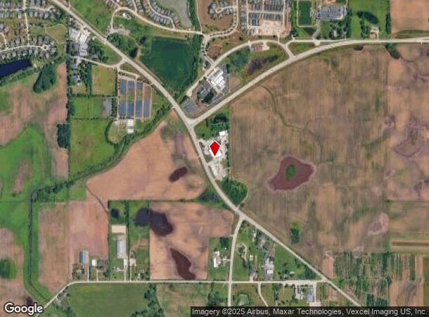
22680 W Il Route 60, Grayslake, IL 60030
NEARBY LISTINGS FOR SALE OR LEASE
-
-
View all Grayslake listings for sale on LoopNet.com
Property Detail
22680 W Il Route 60
Chicago-Naperville-Elgin, IL-IN-WI
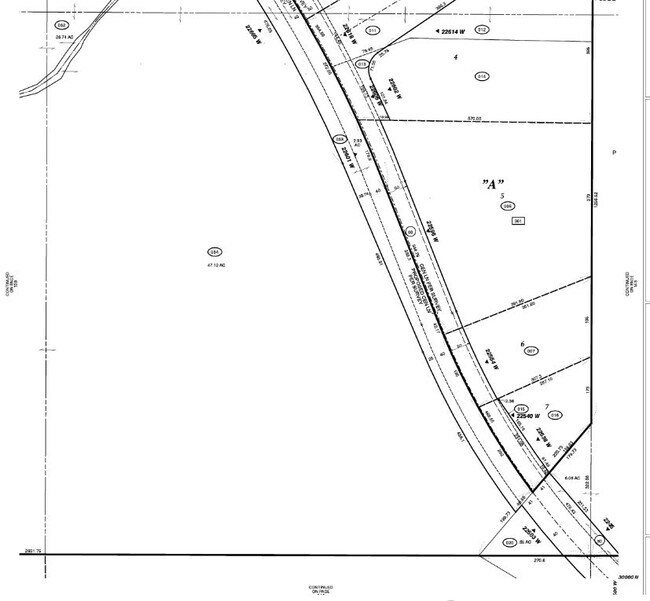
Louis I Behms Fremont Sub No. 1
10-09-301-009
LOUIS I BEHMS FREMONT SUB NO. 1; PT OF LOT 3 COM AT ELY MST COR SD LOT, S59D1822W 116.87 TO POB, CONT S59D1822W ALG SD SLY LN 132.91 TO ELY ROW LN OF HWY 60, NWLY ALG
Taxexempt
Lake
X
Illinois
17097C0137L
3
0
0.14 AC
2024
South Lake County
864110
Chicago
DEMOGRAPHICS near 22680 W Il Route 60
1 Mile
3 Mile
5 Mile
2024 Total Population
2,361
23,016
107,349
2029 Population
2,334
22,661
105,778
Pop Growth 2024-2029
(1.14%)
(1.54%)
(1.46%)
Average Age
46
43
40
2024 Total Households
923
8,603
38,002
HH Growth 2024-2029
(0.98%)
(1.53%)
(1.55%)
Median Household Inc
$75,379
$101,446
$97,628
Avg Household Size
2.50
2.70
2.80
2024 Avg HH Vehicles
2.00
2.00
2.00
Median Home Value
$268,843
$290,793
$260,779
Median Year Built
2001
2001
1991
Nearby Places
Map Layers
Map Styles
 Street
 Aerial
- Restaurants
- Banks
- Shops
- Fitness
- Groceries
PUBLIC TRANSPORTATION
COMMUTER RAIL
Grayslake Station (Md-N) (Milwaukee District North Line - Northeast Illinois Regional Commuter Railroad (Metra))
DRIVE
WALK
Distance
Grayslake Station (Md-N) (Milwaukee District North Line - Northeast Illinois Regional Commuter Railroad (Metra))
9 min
3.9 mi
Prairie Crossing Station (Ncs) (North Central Service - Northeast Illinois Regional Commuter Railroad (Metra))
DRIVE
WALK
Distance
Prairie Crossing Station (Ncs) (North Central Service - Northeast Illinois Regional Commuter Railroad (Metra))
8 min
4.2 mi
AIRPORT
Chicago O'Hare International
DRIVE
WALK
Distance
Chicago O'Hare International
45 min
30.3 mi
Freight Ports
Port Milwaukee
DRIVE
WALK
Distance
Port Milwaukee
71 min
57.0 mi
Nearby Properties
Address
Land Use
TOTAL SIZE
Lot Size
Zoning
Address
Land Use
TOTAL SIZE
Lot Size
Zoning
1,401,971 SF
85.78 AC
Address
Land Use
TOTAL SIZE
Lot Size
Zoning
596,712 SF
35.56 AC
Address
Land Use
TOTAL SIZE
Lot Size
Zoning
298,181 SF
20.41 AC
Address
Land Use
TOTAL SIZE
Lot Size
Zoning
340,535 SF
19.01 AC
Address
Land Use
TOTAL SIZE
Lot Size
Zoning
177,993 SF
10 AC
Address
Land Use
TOTAL SIZE
Lot Size
Zoning
135,180 SF
22.05 AC
Address
Land Use
TOTAL SIZE
Lot Size
Zoning
786,312 SF
14.74 AC
Address
Land Use
TOTAL SIZE
Lot Size
Zoning
175,818 SF
18 AC
Address
Land Use
TOTAL SIZE
Lot Size
Zoning
71,320 SF
26.33 AC
Address
Land Use
TOTAL SIZE
Lot Size
Zoning
79,136 SF
30.10 AC
Address
Land Use
TOTAL SIZE
Lot Size
Zoning
71,064 SF
29.20 AC
Address
Land Use
TOTAL SIZE
Lot Size
Zoning
70,256 SF
33.85 AC
Address
Land Use
TOTAL SIZE
Lot Size
Zoning
58,922 SF
71.36 AC
Address
Land Use
TOTAL SIZE
Lot Size
Zoning
75,798 SF
5 AC
Address
Land Use
TOTAL SIZE
Lot Size
Zoning
107,049 SF
14.42 AC
Address
Land Use
TOTAL SIZE
Lot Size
Zoning
50,137 SF
15.97 AC
Address
Land Use
TOTAL SIZE
Lot Size
Zoning
45,772 SF
89.95 AC
Address
Land Use
TOTAL SIZE
Lot Size
Zoning
50,208 SF
18.37 AC
Address
Land Use
TOTAL SIZE
Lot Size
Zoning
72,684 SF
7.35 AC
Address
Land Use
TOTAL SIZE
Lot Size
Zoning
6,000 SF
111.79 AC
Address
Land Use
TOTAL SIZE
Lot Size
Zoning
0.23 AC
Address
Land Use
TOTAL SIZE
Lot Size
Zoning
664,826 SF
121.65 AC
Address
Land Use
TOTAL SIZE
Lot Size
Zoning
33,158 SF
16.45 AC
Address
Land Use
TOTAL SIZE
Lot Size
Zoning
30,000 SF
16.74 AC
Address
Land Use
TOTAL SIZE
Lot Size
Zoning
11,620 SF
13.58 AC
Address
Land Use
TOTAL SIZE
Lot Size
Zoning
31,657 SF
30.97 AC
Address
Land Use
TOTAL SIZE
Lot Size
Zoning
31,296 SF
18.05 AC
Address
Land Use
TOTAL SIZE
Lot Size
Zoning
163.96 AC
Address
Land Use
TOTAL SIZE
Lot Size
Zoning
28,572 SF
12.40 AC
Address
Land Use
TOTAL SIZE
Lot Size
Zoning
76,088 SF
2.58 AC
The World's #1 Commercial Real Estate Marketplace
Connect with us
© 2025 CoStar Group
The information above has been obtained from sources believed reliable. While we do not doubt its accuracy we have not verified it and make no guarantee, warranty or representation about it. It is your responsibility to independently confirm its accuracy and completeness. Any projections, opinions, assumptions, or estimates used are for example only and do not represent the current or future performance of the property. The value of this transaction to you depends on tax and other factors which should be evaluated by your tax, financial, and legal advisors. You and your advisors should conduct a careful, independent investigation of the property to determine to your satisfaction the suitability of the property for your needs.