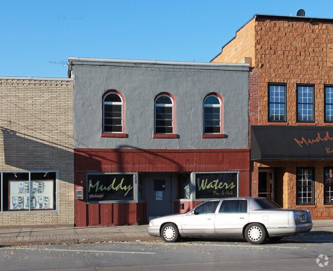
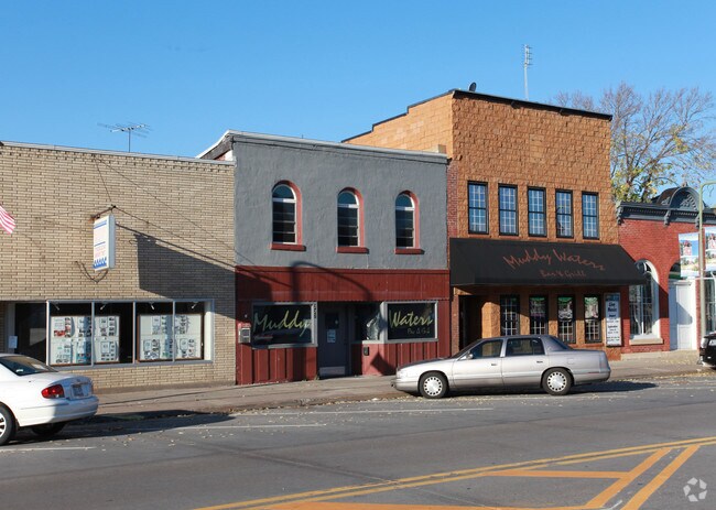
Property Record
227 Broad St N, Prescott, WI 54021

Save to a Folder
{{folder.Name}}
{{folder.ListingIds.length}} Properties
{{folder.ListingIds.length}} Property
Create a New Folder
Property Detail
227 Broad St N
Minneapolis-St. Paul-Bloomington, MN-WI
LOT 3 DOWNTOWN WATERFRONT ASSESSORS PLAT FKA NW HALF LOT 7 BLK C ORIG PLAT (#990)
271-01122-9400
PIERCE
Commercialnec
Wisconsin
C and X Area of minimal flood hazard, usually depicted on FIRMs as above the 500-year flood level.
3
2025
0.09 AC
2025
Pierce County
960500
Minneapolis/St Paul
NEARBY LISTINGS FOR SALE OR LEASE
-
-
View all Prescott listings for sale on LoopNet.com
DEMOGRAPHICS near 227 Broad St N
1 mile
3 mile
5 mile
2025 Total Population
3,361
11,884
31,525
2030 Population
3,457
12,298
32,503
Pop Growth 2025-2030
+ 2.86%
+ 3.48%
+ 3.10%
Average Age
40
41
42
2025 Total Households
1,375
4,836
12,749
HH Growth 2025-2030
+ 2.76%
+ 3.54%
+ 3.11%
Median Household Inc
$91,226
$88,821
$95,853
Avg Household Size
2.40
2.40
2.40
2025 Avg HH Vehicles
2.00
2.00
2.00
Median Home Value
$319,360
$299,590
$340,089
Median Year Built
1981
1980
1985
Nearby Places
Map Layers
Map Styles
 Street
 Aerial
Layers
 Traffic
 Biking
Places
Listings with unknown addresses are not visible on the map
- Restaurants
- Banks
- Shops
- Fitness
- Groceries
PUBLIC TRANSPORTATION
AIRPORT
Minneapolis-St Paul International/Wold-Chamberlain
Drive
Walk
Distance
Minneapolis-St Paul International/Wold-Chamberlain
38 min
27.3 mi
Nearby Properties
Address
Land Use
TOTAL SIZE
Lot Size
Zoning
Address
Land Use
TOTAL SIZE
Lot Size
Zoning
42.33 AC
Address
Land Use
TOTAL SIZE
Lot Size
Zoning
109,735 SF
1.12 AC
Address
Land Use
TOTAL SIZE
Lot Size
Zoning
115,394 SF
4.74 AC
Address
Land Use
TOTAL SIZE
Lot Size
Zoning
115,250 SF
1.84 AC
Address
Land Use
TOTAL SIZE
Lot Size
Zoning
101,400 SF
3.10 AC
Address
Land Use
TOTAL SIZE
Lot Size
Zoning
231,675 SF
92.69 AC
Address
Land Use
TOTAL SIZE
Lot Size
Zoning
5,742 SF
5.05 AC
Address
Land Use
TOTAL SIZE
Lot Size
Zoning
49,091 SF
1.27 AC
Address
Land Use
TOTAL SIZE
Lot Size
Zoning
1.35 AC
Address
Land Use
TOTAL SIZE
Lot Size
Zoning
126,608 SF
10.32 AC
Address
Land Use
TOTAL SIZE
Lot Size
Zoning
30,988 SF
2.33 AC
Address
Land Use
TOTAL SIZE
Lot Size
Zoning
68,024 SF
5.56 AC
Address
Land Use
TOTAL SIZE
Lot Size
Zoning
44,400 SF
6.03 AC
Address
Land Use
TOTAL SIZE
Lot Size
Zoning
Address
Land Use
TOTAL SIZE
Lot Size
Zoning
12.52 AC
Address
Land Use
TOTAL SIZE
Lot Size
Zoning
303,706 SF
5.19 AC
Address
Land Use
TOTAL SIZE
Lot Size
Zoning
42,536 SF
2.81 AC
Address
Land Use
TOTAL SIZE
Lot Size
Zoning
13,664 SF
2.05 AC
Address
Land Use
TOTAL SIZE
Lot Size
Zoning
22,392 SF
1.53 AC
Address
Land Use
TOTAL SIZE
Lot Size
Zoning
13,253 SF
1.80 AC
Address
Land Use
TOTAL SIZE
Lot Size
Zoning
98,580 SF
7.97 AC
Address
Land Use
TOTAL SIZE
Lot Size
Zoning
40.12 AC
Address
Land Use
TOTAL SIZE
Lot Size
Zoning
22,925 SF
2.58 AC
Address
Land Use
TOTAL SIZE
Lot Size
Zoning
19,780 SF
0.79 AC
Address
Land Use
TOTAL SIZE
Lot Size
Zoning
32,253 SF
0.99 AC
Address
Land Use
TOTAL SIZE
Lot Size
Zoning
33,144 SF
4.59 AC
Address
Land Use
TOTAL SIZE
Lot Size
Zoning
0.95 AC
Address
Land Use
TOTAL SIZE
Lot Size
Zoning
35,000 SF
6.75 AC
Address
Land Use
TOTAL SIZE
Lot Size
Zoning
41,000 SF
1.70 AC
The World's #1 Commercial Real Estate Marketplace
Connect with us
© 2026 CoStar Group
The information above has been obtained from sources believed reliable. While we do not doubt its accuracy we have not verified it and make no guarantee, warranty or representation about it. It is your responsibility to independently confirm its accuracy and completeness. Any projections, opinions, assumptions, or estimates used are for example only and do not represent the current or future performance of the property. The value of this transaction to you depends on tax and other factors which should be evaluated by your tax, financial, and legal advisors. You and your advisors should conduct a careful, independent investigation of the property to determine to your satisfaction the suitability of the property for your needs.