Property Record
227 Reservation Way, Augusta, GA 30909
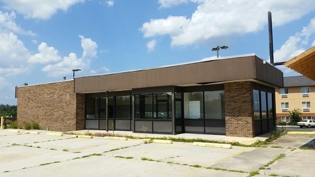

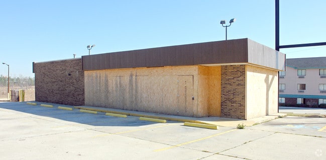

Property Detail
227 Reservation Way
Commercialacreage
Richmond
LI
Georgia
B and X Area of moderate flood hazard, usually the area between the limits of the 100-year and 500-year floods.
0.40 AC
2025
South Richmond County
2025
Augusta/Richmond County
010515
Augusta-Richmond County, GA-SC
1,593 SF
0680133000
NEARBY LISTINGS FOR SALE OR LEASE
DEMOGRAPHICS near 227 Reservation Way
1 mile
3 mile
5 mile
2025 Total Population
2,412
50,557
144,899
2030 Population
2,439
50,245
145,895
Pop Growth 2025-2030
+ 1.12%
(0.62%)
+ 0.69%
Average Age
36
38
38
2025 Total Households
1,063
21,403
58,337
HH Growth 2025-2030
+ 1.32%
(0.44%)
+ 0.65%
Median Household Inc
$44,754
$55,069
$56,638
Avg Household Size
2.20
2.30
2.30
2025 Avg HH Vehicles
2.00
2.00
2.00
Median Home Value
$217,200
$195,646
$206,692
Median Year Built
1984
1981
1978
Nearby Places
Map Layers
Map Styles
 Street
 Aerial
Layers
 Traffic
 Biking
Places
Listings with unknown addresses are not visible on the map
- Restaurants
- Banks
- Shops
- Fitness
- Groceries
PUBLIC TRANSPORTATION
AIRPORT
Augusta Regional at Bush Field
Drive
Walk
Distance
Augusta Regional at Bush Field
19 min
10.0 mi
Nearby Properties
Address
Land Use
TOTAL SIZE
Lot Size
Zoning
Address
Land Use
TOTAL SIZE
Lot Size
Zoning
371,617 SF
13.26 AC
B-2
Address
Land Use
TOTAL SIZE
Lot Size
Zoning
4,357 SF
34 AC
R-3B
Address
Land Use
TOTAL SIZE
Lot Size
Zoning
292,232 SF
39.73 AC
B-2
Address
Land Use
TOTAL SIZE
Lot Size
Zoning
5,541 SF
14.81 AC
B-2
Address
Land Use
TOTAL SIZE
Lot Size
Zoning
5,480 SF
19.05 AC
R-3B
Address
Land Use
TOTAL SIZE
Lot Size
Zoning
984 SF
16.18 AC
R-3C
Address
Land Use
TOTAL SIZE
Lot Size
Zoning
3,498 SF
12.61 AC
B-2
Address
Land Use
TOTAL SIZE
Lot Size
Zoning
1,428 SF
75.91 AC
R-1A
Address
Land Use
TOTAL SIZE
Lot Size
Zoning
2,665 SF
11.80 AC
B-2
Address
Land Use
TOTAL SIZE
Lot Size
Zoning
36,755 SF
12.09 AC
B-2
Address
Land Use
TOTAL SIZE
Lot Size
Zoning
1,620 SF
21.51 AC
R-3B
Address
Land Use
TOTAL SIZE
Lot Size
Zoning
61,236 SF
8.09 AC
R-3B
Address
Land Use
TOTAL SIZE
Lot Size
Zoning
952 SF
29 AC
A
Address
Land Use
TOTAL SIZE
Lot Size
Zoning
3,829 SF
35.30 AC
R-3B
Address
Land Use
TOTAL SIZE
Lot Size
Zoning
38,080 SF
19.19 AC
R-3B
Address
Land Use
TOTAL SIZE
Lot Size
Zoning
4,108 SF
14.12 AC
B-2
Address
Land Use
TOTAL SIZE
Lot Size
Zoning
1,782 SF
26.27 AC
R-3A
Address
Land Use
TOTAL SIZE
Lot Size
Zoning
640 SF
12.17 AC
B-1
Address
Land Use
TOTAL SIZE
Lot Size
Zoning
6,323 SF
25.49 AC
R-3C
Address
Land Use
TOTAL SIZE
Lot Size
Zoning
8,640 SF
13.15 AC
R-3B
Address
Land Use
TOTAL SIZE
Lot Size
Zoning
102,060 SF
45.63 AC
R-3B
Address
Land Use
TOTAL SIZE
Lot Size
Zoning
72,381 SF
0.95 AC
Address
Land Use
TOTAL SIZE
Lot Size
Zoning
42,617 SF
40.26 AC
R-1_B-1
Address
Land Use
TOTAL SIZE
Lot Size
Zoning
68,600 SF
20.94 AC
R-3A
Address
Land Use
TOTAL SIZE
Lot Size
Zoning
62,440 SF
5.70 AC
B-2
Address
Land Use
TOTAL SIZE
Lot Size
Zoning
11,584 SF
10.34 AC
R-3B
Address
Land Use
TOTAL SIZE
Lot Size
Zoning
156,372 SF
17.81 AC
B-2
Address
Land Use
TOTAL SIZE
Lot Size
Zoning
56,631 SF
11.62 AC
R-1A, B-2
Address
Land Use
TOTAL SIZE
Lot Size
Zoning
106,072 SF
9.35 AC
007
Address
Land Use
TOTAL SIZE
Lot Size
Zoning
226,626 SF
34.18 AC
B-2_A
The World's #1 Commercial Real Estate Marketplace
Connect with us
© 2026 CoStar Group
The information above has been obtained from sources believed reliable. While we do not doubt its accuracy we have not verified it and make no guarantee, warranty or representation about it. It is your responsibility to independently confirm its accuracy and completeness. Any projections, opinions, assumptions, or estimates used are for example only and do not represent the current or future performance of the property. The value of this transaction to you depends on tax and other factors which should be evaluated by your tax, financial, and legal advisors. You and your advisors should conduct a careful, independent investigation of the property to determine to your satisfaction the suitability of the property for your needs.