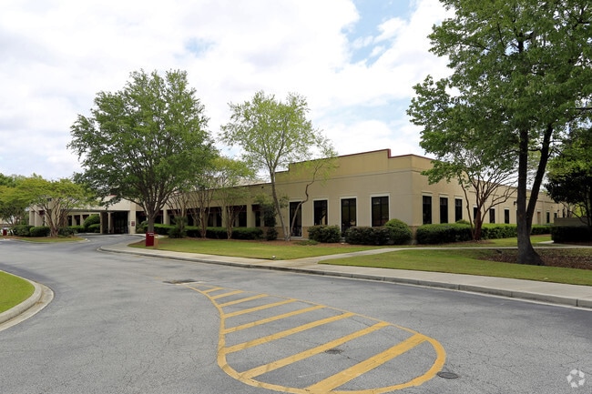
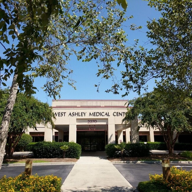
Property Record
2270 Ashley Crossing Dr, Charleston, SC 29414

Save to a Folder
{{folder.Name}}
{{folder.ListingIds.length}} Properties
{{folder.ListingIds.length}} Property
Create a New Folder
Current Lease Availabilities
Property Detail
2270 Ashley Crossing Dr
309-00-00-007
SUBDIVISION NAME -PART MAGWOOD TRACT DESCRIPTION -TRACT 4A PROPOSED HOSPITAL SITE SITE NAME -FUTURE ROPER HOSPITAL SITE
Officebuilding
Charleston
AE The base floodplain where base flood elevations are provided. AE Zones are now used on new format FIRMs instead of A1-A30 Zones.
South Carolina
2025
8.96 AC
2024
West Ashley
002613
Charleston/N Charleston
48,578 SF
Charleston-North Charleston, SC
NEARBY LISTINGS FOR SALE OR LEASE
DEMOGRAPHICS near 2270 Ashley Crossing Dr
1 mile
3 mile
5 mile
2025 Total Population
10,950
57,432
124,245
2030 Population
11,396
59,236
128,730
Pop Growth 2025-2030
+ 4.07%
+ 3.14%
+ 3.61%
Average Age
40
41
40
2025 Total Households
5,432
26,276
53,758
HH Growth 2025-2030
+ 4.16%
+ 3.20%
+ 3.64%
Median Household Inc
$75,559
$85,532
$84,498
Avg Household Size
1.90
2.10
2.20
2025 Avg HH Vehicles
1.00
2.00
2.00
Median Home Value
$378,864
$407,719
$415,569
Median Year Built
1987
1982
1984
Nearby Places
Map Layers
Map Styles
 Street
 Aerial
Layers
 Traffic
 Biking
Places
Listings with unknown addresses are not visible on the map
- Restaurants
- Banks
- Shops
- Fitness
- Groceries
PUBLIC TRANSPORTATION
COMMUTER RAIL
Charleston Amtrak Station (Palmetto - Amtrak, Silver Meteor - Amtrak)
Drive
Walk
Distance
Charleston Amtrak Station (Palmetto - Amtrak, Silver Meteor - Amtrak)
13 min
7.5 mi
AIRPORT
Charleston AFB/International
Drive
Walk
Distance
Charleston AFB/International
16 min
10.1 mi
Freight Ports
Veterans Terminal
Drive
Walk
Distance
Veterans Terminal
17 min
9.2 mi
Nearby Properties
Address
Land Use
TOTAL SIZE
Lot Size
Zoning
Address
Land Use
TOTAL SIZE
Lot Size
Zoning
9,778 SF
11.90 AC
Address
Land Use
TOTAL SIZE
Lot Size
Zoning
21,900 SF
5.96 AC
Address
Land Use
TOTAL SIZE
Lot Size
Zoning
Address
Land Use
TOTAL SIZE
Lot Size
Zoning
11,631 SF
8 AC
Address
Land Use
TOTAL SIZE
Lot Size
Zoning
78,810 SF
3.33 AC
Address
Land Use
TOTAL SIZE
Lot Size
Zoning
36,587 SF
17.75 AC
Address
Land Use
TOTAL SIZE
Lot Size
Zoning
17,271 SF
3.65 AC
Address
Land Use
TOTAL SIZE
Lot Size
Zoning
112,860 SF
12 AC
Address
Land Use
TOTAL SIZE
Lot Size
Zoning
6,036 SF
8.79 AC
Address
Land Use
TOTAL SIZE
Lot Size
Zoning
5.54 AC
Address
Land Use
TOTAL SIZE
Lot Size
Zoning
42,500 SF
3.62 AC
Address
Land Use
TOTAL SIZE
Lot Size
Zoning
30,196 SF
1.58 AC
Address
Land Use
TOTAL SIZE
Lot Size
Zoning
3,275 SF
4.18 AC
Address
Land Use
TOTAL SIZE
Lot Size
Zoning
16,917 SF
2.40 AC
Address
Land Use
TOTAL SIZE
Lot Size
Zoning
50,356 SF
5.19 AC
Address
Land Use
TOTAL SIZE
Lot Size
Zoning
6,531 SF
3.11 AC
Address
Land Use
TOTAL SIZE
Lot Size
Zoning
3,520 SF
7.70 AC
Address
Land Use
TOTAL SIZE
Lot Size
Zoning
56.56 AC
Address
Land Use
TOTAL SIZE
Lot Size
Zoning
26,010 SF
4.32 AC
Address
Land Use
TOTAL SIZE
Lot Size
Zoning
34,609 SF
3.57 AC
Address
Land Use
TOTAL SIZE
Lot Size
Zoning
25,749 SF
2.49 AC
Address
Land Use
TOTAL SIZE
Lot Size
Zoning
Address
Land Use
TOTAL SIZE
Lot Size
Zoning
Address
Land Use
TOTAL SIZE
Lot Size
Zoning
75,984 SF
2.15 AC
Address
Land Use
TOTAL SIZE
Lot Size
Zoning
11,300 SF
25.42 AC
Address
Land Use
TOTAL SIZE
Lot Size
Zoning
Address
Land Use
TOTAL SIZE
Lot Size
Zoning
18,500 SF
0.90 AC
Address
Land Use
TOTAL SIZE
Lot Size
Zoning
7,492 SF
9.54 AC
Address
Land Use
TOTAL SIZE
Lot Size
Zoning
17.22 AC
Address
Land Use
TOTAL SIZE
Lot Size
Zoning
The World's #1 Commercial Real Estate Marketplace
Connect with us
© 2026 CoStar Group
The information above has been obtained from sources believed reliable. While we do not doubt its accuracy we have not verified it and make no guarantee, warranty or representation about it. It is your responsibility to independently confirm its accuracy and completeness. Any projections, opinions, assumptions, or estimates used are for example only and do not represent the current or future performance of the property. The value of this transaction to you depends on tax and other factors which should be evaluated by your tax, financial, and legal advisors. You and your advisors should conduct a careful, independent investigation of the property to determine to your satisfaction the suitability of the property for your needs.