Property Record
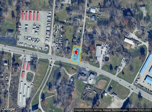
2270 State Route 125, Amelia, OH 45102
NEARBY LISTINGS FOR SALE OR LEASE
Property Detail
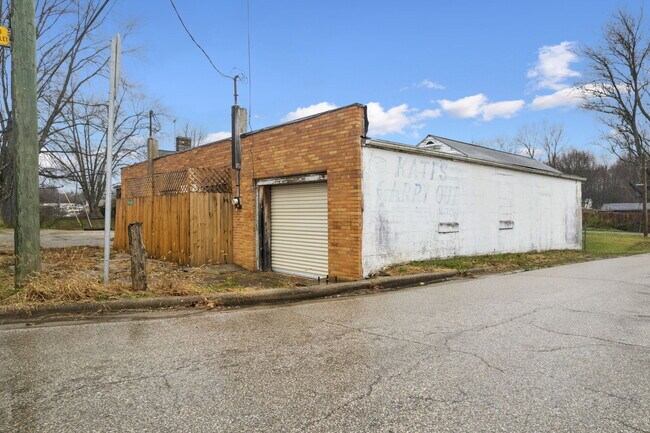
2270 State Route 125
Servicestationmarket
Clermont
X
Ohio
39025C0245G
0.49 AC
2024
Outlying Cincinnati East
2024
Cincinnati/Dayton
041001
Cincinnati, OH-KY-IN
2,848 SF
03-20-18A-098
DEMOGRAPHICS near 2270 State Route 125
1 Mile
3 Mile
5 Mile
2024 Total Population
1,571
10,055
37,403
2029 Population
1,639
10,431
38,553
Pop Growth 2024-2029
+ 4.33%
+ 3.74%
+ 3.07%
Average Age
40
39
39
2024 Total Households
589
3,805
14,005
HH Growth 2024-2029
+ 4.41%
+ 3.78%
+ 3.11%
Median Household Inc
$55,930
$56,726
$65,292
Avg Household Size
2.60
2.60
2.60
2024 Avg HH Vehicles
2.00
2.00
2.00
Median Home Value
$166,223
$191,022
$197,561
Median Year Built
1992
1989
1990
Nearby Places
Map Layers
Map Styles
 Street
 Aerial
- Restaurants
- Banks
- Shops
- Fitness
- Groceries
PUBLIC TRANSPORTATION
AIRPORT
Cincinnati/Northern Kentucky International
DRIVE
WALK
Distance
Cincinnati/Northern Kentucky International
50 min
32.4 mi
Freight Ports
Port of Toledo
DRIVE
WALK
Distance
Port of Toledo
259 min
220.8 mi
SALE & LEASE HISTORY
LISTING DATE
SALE/LEASE

Jan 24, 2017
For Sale
Nearby Properties
Address
Land Use
TOTAL SIZE
Lot Size
Zoning
Address
Land Use
TOTAL SIZE
Lot Size
Zoning
216,760 SF
26.34 AC
Address
Land Use
TOTAL SIZE
Lot Size
Zoning
19,654 SF
11.57 AC
Address
Land Use
TOTAL SIZE
Lot Size
Zoning
44.65 AC
Address
Land Use
TOTAL SIZE
Lot Size
Zoning
7,200 SF
58.94 AC
Address
Land Use
TOTAL SIZE
Lot Size
Zoning
23,674 SF
3.95 AC
Address
Land Use
TOTAL SIZE
Lot Size
Zoning
23.04 AC
Address
Land Use
TOTAL SIZE
Lot Size
Zoning
16,100 SF
2.80 AC
Address
Land Use
TOTAL SIZE
Lot Size
Zoning
45,684 SF
6.07 AC
Address
Land Use
TOTAL SIZE
Lot Size
Zoning
13,318 SF
5 AC
Address
Land Use
TOTAL SIZE
Lot Size
Zoning
1,600 SF
5.87 AC
Address
Land Use
TOTAL SIZE
Lot Size
Zoning
12,150 SF
3.72 AC
Address
Land Use
TOTAL SIZE
Lot Size
Zoning
2,448 SF
5.58 AC
Address
Land Use
TOTAL SIZE
Lot Size
Zoning
Address
Land Use
TOTAL SIZE
Lot Size
Zoning
Address
Land Use
TOTAL SIZE
Lot Size
Zoning
14,372 SF
4.95 AC
Address
Land Use
TOTAL SIZE
Lot Size
Zoning
8,721 SF
15.69 AC
Address
Land Use
TOTAL SIZE
Lot Size
Zoning
5,702 SF
4.62 AC
Address
Land Use
TOTAL SIZE
Lot Size
Zoning
8,727 SF
1.82 AC
Address
Land Use
TOTAL SIZE
Lot Size
Zoning
5,288 SF
1.17 AC
Address
Land Use
TOTAL SIZE
Lot Size
Zoning
660 SF
21.52 AC
Address
Land Use
TOTAL SIZE
Lot Size
Zoning
8,320 SF
2 AC
Address
Land Use
TOTAL SIZE
Lot Size
Zoning
1,485 SF
17.93 AC
Address
Land Use
TOTAL SIZE
Lot Size
Zoning
4,858 SF
1.43 AC
Address
Land Use
TOTAL SIZE
Lot Size
Zoning
33.89 AC
Address
Land Use
TOTAL SIZE
Lot Size
Zoning
4,318 SF
15.29 AC
Address
Land Use
TOTAL SIZE
Lot Size
Zoning
12,150 SF
2.07 AC
Address
Land Use
TOTAL SIZE
Lot Size
Zoning
16,016 SF
1.18 AC
Address
Land Use
TOTAL SIZE
Lot Size
Zoning
1,773 SF
217.60 AC
Address
Land Use
TOTAL SIZE
Lot Size
Zoning
1,500 SF
192.06 AC
Address
Land Use
TOTAL SIZE
Lot Size
Zoning
6,227 SF
23.05 AC
The World's #1 Commercial Real Estate Marketplace
Connect with us
© 2025 CoStar Group
The information above has been obtained from sources believed reliable. While we do not doubt its accuracy we have not verified it and make no guarantee, warranty or representation about it. It is your responsibility to independently confirm its accuracy and completeness. Any projections, opinions, assumptions, or estimates used are for example only and do not represent the current or future performance of the property. The value of this transaction to you depends on tax and other factors which should be evaluated by your tax, financial, and legal advisors. You and your advisors should conduct a careful, independent investigation of the property to determine to your satisfaction the suitability of the property for your needs.