Property Record
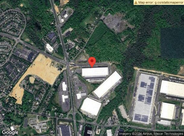
2270 Us Highway 130 Rte, Dayton, NJ 08810
NEARBY LISTINGS FOR SALE OR LEASE
Property Detail
2270 Us Highway 130 Rte
New York-Jersey City-White Plains, NY-NJ
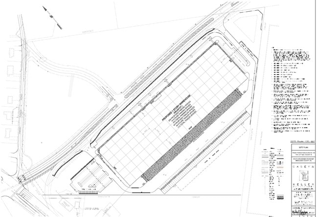
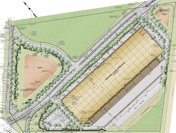
20.688 AC
21-00018-0000-00019-011
Middlesex
Warehouse
New Jersey
X
19.11
34023C0138F
20.69 AC
2024
Exit 8A
2025
Northern New Jersey
008502
DEMOGRAPHICS near 2270 Us Highway 130 Rte
1 Mile
3 Mile
5 Mile
2024 Total Population
4,086
23,782
125,025
2029 Population
4,068
23,812
124,478
Pop Growth 2024-2029
(0.44%)
+ 0.13%
(0.44%)
Average Age
39
40
42
2024 Total Households
1,293
7,968
46,442
HH Growth 2024-2029
(0.46%)
+ 0.04%
(0.65%)
Median Household Inc
$138,071
$128,591
$116,098
Avg Household Size
3.10
2.90
2.60
2024 Avg HH Vehicles
2.00
2.00
2.00
Median Home Value
$454,640
$476,203
$457,734
Median Year Built
1993
1991
1986
Nearby Places
- Restaurants
- Banks
- Shops
- Fitness
- Groceries
PUBLIC TRANSPORTATION
COMMUTER RAIL
Jersey Avenue (Northeast Corridor Line - NJ Transit Commuter Rail (NJ Transit))
DRIVE
WALK
Distance
Jersey Avenue (Northeast Corridor Line - NJ Transit Commuter Rail (NJ Transit))
20 min
8.7 mi
AIRPORT
Trenton Mercer
DRIVE
WALK
Distance
Trenton Mercer
33 min
22.8 mi
Newark Liberty International
DRIVE
WALK
Distance
Newark Liberty International
48 min
35.9 mi
Freight Ports
New York Container Terminal
DRIVE
WALK
Distance
New York Container Terminal
43 min
28.7 mi
SALE & LEASE HISTORY
LISTING DATE
SALE/LEASE

Dec 02, 2016
For Lease
Nearby Properties
Address
Land Use
TOTAL SIZE
Lot Size
Zoning
Address
Land Use
TOTAL SIZE
Lot Size
Zoning
212.16 AC
I-3
Address
Land Use
TOTAL SIZE
Lot Size
Zoning
42.10 AC
LI5
Address
Land Use
TOTAL SIZE
Lot Size
Zoning
1,154,372 SF
167.04 AC
LI
Address
Land Use
TOTAL SIZE
Lot Size
Zoning
1,145,608 SF
73.19 AC
LI
Address
Land Use
TOTAL SIZE
Lot Size
Zoning
80.34 AC
LI5
Address
Land Use
TOTAL SIZE
Lot Size
Zoning
983,940 SF
62.53 AC
LI
Address
Land Use
TOTAL SIZE
Lot Size
Zoning
103.93 AC
ERR
Address
Land Use
TOTAL SIZE
Lot Size
Zoning
87.65 AC
LI-4
Address
Land Use
TOTAL SIZE
Lot Size
Zoning
0.46 AC
AH
Address
Land Use
TOTAL SIZE
Lot Size
Zoning
207.40 AC
OR
Address
Land Use
TOTAL SIZE
Lot Size
Zoning
28,155 SF
90.95 AC
I3R4
Address
Land Use
TOTAL SIZE
Lot Size
Zoning
72.62 AC
PL
Address
Land Use
TOTAL SIZE
Lot Size
Zoning
29.74 AC
R30
Address
Land Use
TOTAL SIZE
Lot Size
Zoning
79.67 AC
I-3
Address
Land Use
TOTAL SIZE
Lot Size
Zoning
50.73 AC
I-3
Address
Land Use
TOTAL SIZE
Lot Size
Zoning
18.93 AC
R30
Address
Land Use
TOTAL SIZE
Lot Size
Zoning
44.80 AC
LI-4
Address
Land Use
TOTAL SIZE
Lot Size
Zoning
49.12 AC
LI-4
Address
Land Use
TOTAL SIZE
Lot Size
Zoning
3,555 SF
25.73 AC
PL
Address
Land Use
TOTAL SIZE
Lot Size
Zoning
56 AC
LI-4
Address
Land Use
TOTAL SIZE
Lot Size
Zoning
48.39 AC
LI-4
Address
Land Use
TOTAL SIZE
Lot Size
Zoning
299,532 SF
22.35 AC
LI
Address
Land Use
TOTAL SIZE
Lot Size
Zoning
50.34 AC
I-3
Address
Land Use
TOTAL SIZE
Lot Size
Zoning
626,675 SF
54.07 AC
LI-2
Address
Land Use
TOTAL SIZE
Lot Size
Zoning
43.90 AC
I-3
Address
Land Use
TOTAL SIZE
Lot Size
Zoning
413,092 SF
35.48 AC
LI-4
Address
Land Use
TOTAL SIZE
Lot Size
Zoning
227,175 SF
16.43 AC
LI
Address
Land Use
TOTAL SIZE
Lot Size
Zoning
34.73 AC
LI-4
Address
Land Use
TOTAL SIZE
Lot Size
Zoning
36.59 AC
I-3
Address
Land Use
TOTAL SIZE
Lot Size
Zoning
5.58 AC
LI
The World's #1 Commercial Real Estate Marketplace
Connect with us
© 2025 CoStar Group
The information above has been obtained from sources believed reliable. While we do not doubt its accuracy we have not verified it and make no guarantee, warranty or representation about it. It is your responsibility to independently confirm its accuracy and completeness. Any projections, opinions, assumptions, or estimates used are for example only and do not represent the current or future performance of the property. The value of this transaction to you depends on tax and other factors which should be evaluated by your tax, financial, and legal advisors. You and your advisors should conduct a careful, independent investigation of the property to determine to your satisfaction the suitability of the property for your needs.