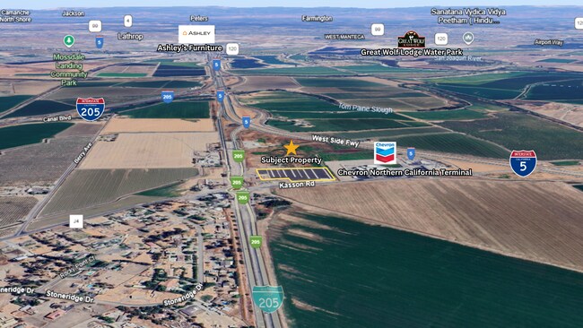
Property Record
3566 W 11Th St, Tracy, CA 95304


Current Lease Availabilities
Property Detail
3566 W 11Th St
239-060-18
06-FM PT 239-060-09/PT TO 19 PER 06045052/06025901
Farms
San Joaquin
IW
California
AE The base floodplain where base flood elevations are provided. AE Zones are now used on new format FIRMs instead of A1-A30 Zones.
41.11 AC
2025
Tracy/Manteca
2025
Stockton/Modesto
005214
Stockton-Lodi, CA
1,422 SF
NEARBY LISTINGS FOR SALE OR LEASE
DEMOGRAPHICS near 3566 W 11Th St
1 mile
3 mile
5 mile
2025 Total Population
416
3,107
63,576
2030 Population
441
3,251
67,550
Pop Growth 2025-2030
+ 6.01%
+ 4.63%
+ 6.25%
Average Age
38
39
37
2025 Total Households
69
448
18,434
HH Growth 2025-2030
+ 10.14%
+ 8.93%
+ 6.36%
Median Household Inc
$143,055
$136,830
$112,113
Avg Household Size
3.50
3.50
3.30
2025 Avg HH Vehicles
2.00
2.00
2.00
Median Home Value
$759,090
$754,531
$713,907
Median Year Built
2011
2011
1997
Nearby Places
Map Layers
Map Styles
 Street
 Aerial
Transit
 Traffic
 Biking
Places
Listings with unknown addresses are not visible on the map
- Restaurants
- Banks
- Shops
- Fitness
- Groceries
PUBLIC TRANSPORTATION
COMMUTER RAIL
Lathrop Station (ACE Train - Altamont Corridor Express)
Drive
Walk
Distance
Lathrop Station (ACE Train - Altamont Corridor Express)
8 min
6.0 mi
Tracy Station (ACE Train - Altamont Corridor Express)
Drive
Walk
Distance
Tracy Station (ACE Train - Altamont Corridor Express)
14 min
8.7 mi
AIRPORT
Stockton Metro
Drive
Walk
Distance
Stockton Metro
18 min
13.9 mi
Freight Ports
Port of Stockton
Drive
Walk
Distance
Port of Stockton
20 min
17.2 mi
Nearby Properties
Address
Land Use
TOTAL SIZE
Lot Size
Zoning
Address
Land Use
TOTAL SIZE
Lot Size
Zoning
3,485,402 SF
86.48 AC
Address
Land Use
TOTAL SIZE
Lot Size
Zoning
657,600 SF
44.03 AC
Address
Land Use
TOTAL SIZE
Lot Size
Zoning
749,840 SF
37.96 AC
Address
Land Use
TOTAL SIZE
Lot Size
Zoning
24.07 AC
Address
Land Use
TOTAL SIZE
Lot Size
Zoning
567,870 SF
36.41 AC
M1
Address
Land Use
TOTAL SIZE
Lot Size
Zoning
827,280 SF
36.18 AC
Address
Land Use
TOTAL SIZE
Lot Size
Zoning
381,600 SF
19.46 AC
Address
Land Use
TOTAL SIZE
Lot Size
Zoning
309,108 SF
19.39 AC
Address
Land Use
TOTAL SIZE
Lot Size
Zoning
532,500 SF
25.15 AC
Address
Land Use
TOTAL SIZE
Lot Size
Zoning
210,000 SF
12.93 AC
Address
Land Use
TOTAL SIZE
Lot Size
Zoning
398,400 SF
28.40 AC
Address
Land Use
TOTAL SIZE
Lot Size
Zoning
10,000 SF
20.18 AC
Address
Land Use
TOTAL SIZE
Lot Size
Zoning
38.63 AC
Address
Land Use
TOTAL SIZE
Lot Size
Zoning
211,252 SF
18.90 AC
Address
Land Use
TOTAL SIZE
Lot Size
Zoning
312,500 SF
17.73 AC
Address
Land Use
TOTAL SIZE
Lot Size
Zoning
390,416 SF
17.80 AC
Address
Land Use
TOTAL SIZE
Lot Size
Zoning
3,284 SF
234.60 AC
AG40
Address
Land Use
TOTAL SIZE
Lot Size
Zoning
4.48 AC
Address
Land Use
TOTAL SIZE
Lot Size
Zoning
285,730 SF
14.14 AC
Address
Land Use
TOTAL SIZE
Lot Size
Zoning
90,000 SF
6.56 AC
Address
Land Use
TOTAL SIZE
Lot Size
Zoning
246.80 AC
Address
Land Use
TOTAL SIZE
Lot Size
Zoning
14.59 AC
IW
Address
Land Use
TOTAL SIZE
Lot Size
Zoning
11.41 AC
Address
Land Use
TOTAL SIZE
Lot Size
Zoning
5,600 SF
7.62 AC
IL
Address
Land Use
TOTAL SIZE
Lot Size
Zoning
10,400 SF
7.58 AC
IL
Address
Land Use
TOTAL SIZE
Lot Size
Zoning
5.35 AC
Address
Land Use
TOTAL SIZE
Lot Size
Zoning
6.32 AC
Address
Land Use
TOTAL SIZE
Lot Size
Zoning
1,120 SF
32.58 AC
AG40
The World's #1 Commercial Real Estate Marketplace
Connect with us
© 2026 CoStar Group
The information above has been obtained from sources believed reliable. While we do not doubt its accuracy we have not verified it and make no guarantee, warranty or representation about it. It is your responsibility to independently confirm its accuracy and completeness. Any projections, opinions, assumptions, or estimates used are for example only and do not represent the current or future performance of the property. The value of this transaction to you depends on tax and other factors which should be evaluated by your tax, financial, and legal advisors. You and your advisors should conduct a careful, independent investigation of the property to determine to your satisfaction the suitability of the property for your needs.