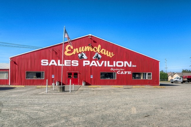
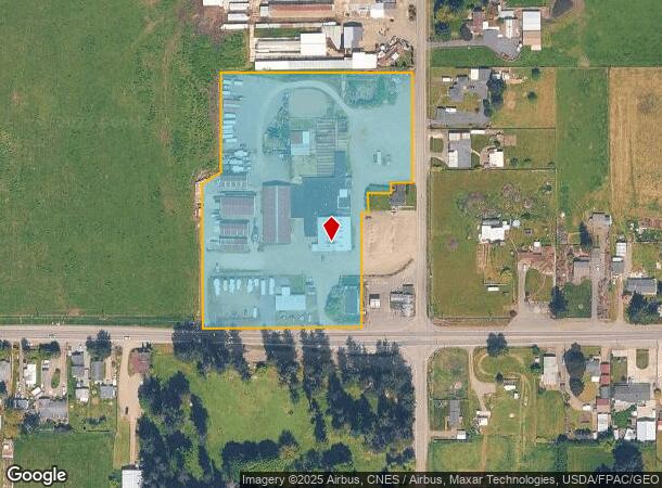
Property Record
22712 Se 436Th St, Enumclaw, WA 98022


NEARBY LISTINGS FOR SALE OR LEASE
Property Detail
22712 Se 436Th St
Seattle-Tacoma-Bellevue, WA
Lla 8612040
212006-9039
POR NE 1/4 NE 1/4 DAF: BEG AT SE COR SD NE 1/4 NE 1/4 TH N 00-30-36 E ALG E LN SD SEC 30.00 FT TH N 89-38-38 W & PLW S LN SD NE 1/4 NE 1/4 152.00 FT TO TPOB TH N 89-38-38 W 393.19 FT TH N 01-18-51 E 356.37 FT TH N 67-12-38 E 47.91 FT TH N 00-36-40 E
Farms
King
X
Washington
53033C1510G
b
2025
6.23 AC
2024
E King County
031301
Seattle/Puget Sound
51,980 SF
DEMOGRAPHICS near 22712 Se 436Th St
1 mile
3 mile
5 mile
2024 Total Population
750
15,431
32,688
2029 Population
748
15,528
33,057
Pop Growth 2024-2029
(0.27%)
+ 0.63%
+ 1.13%
Average Age
44
41
41
2024 Total Households
281
5,925
12,069
HH Growth 2024-2029
(0.71%)
+ 0.35%
+ 0.91%
Median Household Inc
$111,111
$107,890
$112,167
Avg Household Size
2.60
2.50
2.60
2024 Avg HH Vehicles
3.00
2.00
2.00
Median Home Value
$715,073
$536,909
$553,796
Median Year Built
1963
1979
1984
Nearby Places
Map Layers
Map Styles
 Street
 Aerial
Transit
 Traffic
 Biking
Places
Listings with unknown addresses are not visible on the map
- Restaurants
- Banks
- Shops
- Fitness
- Groceries
PUBLIC TRANSPORTATION
AIRPORT
Seattle-Tacoma International
Drive
Walk
Distance
Seattle-Tacoma International
48 min
26.5 mi
SALE & LEASE HISTORY
LISTING DATE
SALE/LEASE

Sep 24, 2016
For Sale
Nearby Properties
Address
Land Use
TOTAL SIZE
Lot Size
Zoning
Address
Land Use
TOTAL SIZE
Lot Size
Zoning
257,034 SF
39.18 AC
P
Address
Land Use
TOTAL SIZE
Lot Size
Zoning
90,817 SF
3.38 AC
H
Address
Land Use
TOTAL SIZE
Lot Size
Zoning
Address
Land Use
TOTAL SIZE
Lot Size
Zoning
126,225 SF
8.42 AC
R-4
Address
Land Use
TOTAL SIZE
Lot Size
Zoning
145,161 SF
9.07 AC
LI
Address
Land Use
TOTAL SIZE
Lot Size
Zoning
28,384 SF
6.15 AC
P
Address
Land Use
TOTAL SIZE
Lot Size
Zoning
100,000 SF
44.10 AC
P
Address
Land Use
TOTAL SIZE
Lot Size
Zoning
3,600 SF
26.89 AC
RMHP
Address
Land Use
TOTAL SIZE
Lot Size
Zoning
4,320 SF
21.72 AC
RMHP
Address
Land Use
TOTAL SIZE
Lot Size
Zoning
47,375 SF
40.51 AC
P
Address
Land Use
TOTAL SIZE
Lot Size
Zoning
65,352 SF
5.62 AC
R-4
Address
Land Use
TOTAL SIZE
Lot Size
Zoning
90,242 SF
0.21 AC
CB1
Address
Land Use
TOTAL SIZE
Lot Size
Zoning
42,444 SF
3.12 AC
R-4
Address
Land Use
TOTAL SIZE
Lot Size
Zoning
87,334 SF
33.88 AC
P
Address
Land Use
TOTAL SIZE
Lot Size
Zoning
47,992 SF
3.49 AC
NMU
Address
Land Use
TOTAL SIZE
Lot Size
Zoning
1,180 SF
2.21 AC
R-4
Address
Land Use
TOTAL SIZE
Lot Size
Zoning
39,600 SF
2.66 AC
R-4
Address
Land Use
TOTAL SIZE
Lot Size
Zoning
21,640 SF
2.42 AC
GO
Address
Land Use
TOTAL SIZE
Lot Size
Zoning
52,557 SF
3.59 AC
P
Address
Land Use
TOTAL SIZE
Lot Size
Zoning
45,007 SF
11.59 AC
P
Address
Land Use
TOTAL SIZE
Lot Size
Zoning
33,280 SF
2.79 AC
R-4
Address
Land Use
TOTAL SIZE
Lot Size
Zoning
56,514 SF
3.66 AC
HCB
Address
Land Use
TOTAL SIZE
Lot Size
Zoning
44,284 SF
4.31 AC
HCB
Address
Land Use
TOTAL SIZE
Lot Size
Zoning
24,052 SF
1.91 AC
R-4
Address
Land Use
TOTAL SIZE
Lot Size
Zoning
20,592 SF
2.41 AC
R-4
Address
Land Use
TOTAL SIZE
Lot Size
Zoning
18,131 SF
1.11 AC
GO-H
Address
Land Use
TOTAL SIZE
Lot Size
Zoning
10,573 SF
5.51 AC
P
Address
Land Use
TOTAL SIZE
Lot Size
Zoning
36,160 SF
1.22 AC
LI
Address
Land Use
TOTAL SIZE
Lot Size
Zoning
14,208 SF
2.16 AC
R-4
Address
Land Use
TOTAL SIZE
Lot Size
Zoning
41,376 SF
1.91 AC
LI
The World's #1 Commercial Real Estate Marketplace
Connect with us
© 2026 CoStar Group
The information above has been obtained from sources believed reliable. While we do not doubt its accuracy we have not verified it and make no guarantee, warranty or representation about it. It is your responsibility to independently confirm its accuracy and completeness. Any projections, opinions, assumptions, or estimates used are for example only and do not represent the current or future performance of the property. The value of this transaction to you depends on tax and other factors which should be evaluated by your tax, financial, and legal advisors. You and your advisors should conduct a careful, independent investigation of the property to determine to your satisfaction the suitability of the property for your needs.