Property Record
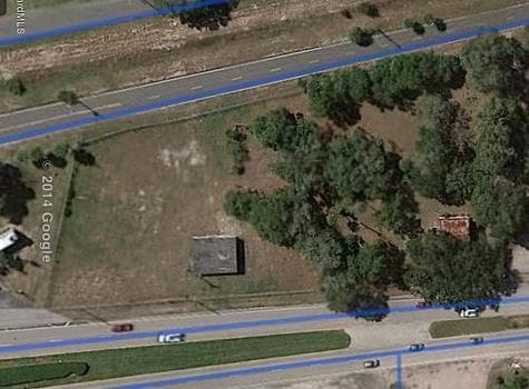
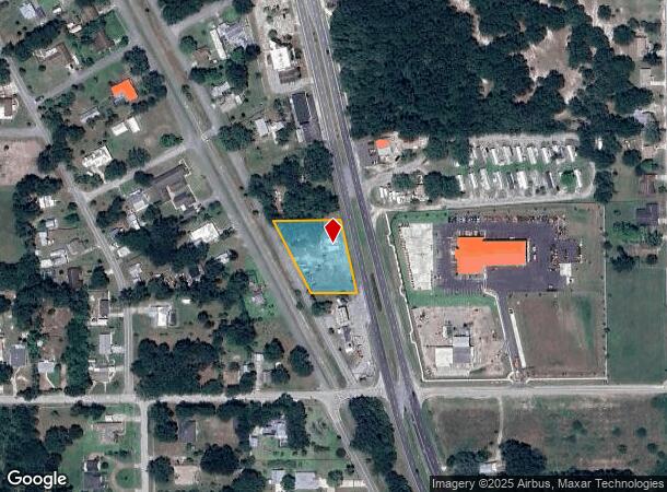
2272 Us Highway 1, Mims, FL 32754
NEARBY LISTINGS FOR SALE OR LEASE
Property Detail
2272 Us Highway 1
Palm Bay-Melbourne-Titusville, FL
Hansells Subd
21-35-17-57-00000.0-0001.00
HANSELLS SUBD LOTS 1 TO 3 & N 23.3 FT OF LOT 4
Storageyardjunkautowreckingsalvage
Brevard
X
Florida
12009C0115H
1
2024
0.92 AC
2025
Brevard County
060103
Orlando
1,200 SF
DEMOGRAPHICS near 2272 Us Highway 1
1 Mile
3 Mile
5 Mile
2024 Total Population
2,903
20,963
38,401
2029 Population
3,216
22,989
42,171
Pop Growth 2024-2029
+ 10.78%
+ 9.66%
+ 9.82%
Average Age
47
45
44
2024 Total Households
1,247
8,587
16,015
HH Growth 2024-2029
+ 10.83%
+ 9.57%
+ 9.67%
Median Household Inc
$46,675
$55,484
$51,538
Avg Household Size
2.30
2.40
2.30
2024 Avg HH Vehicles
2.00
2.00
2.00
Median Home Value
$174,528
$214,388
$219,771
Median Year Built
1984
1982
1982
Nearby Places
Map Layers
Map Styles
 Street
 Aerial
- Restaurants
- Banks
- Shops
- Fitness
- Groceries
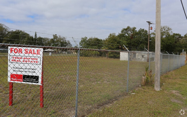
SALE & LEASE HISTORY
LISTING DATE
SALE/LEASE

Jan 17, 2017
For Sale
Nearby Properties
Address
Land Use
TOTAL SIZE
Lot Size
Zoning
Address
Land Use
TOTAL SIZE
Lot Size
Zoning
440,368 SF
60.44 AC
HM
Address
Land Use
TOTAL SIZE
Lot Size
Zoning
172,172 SF
116.12 AC
P
Address
Land Use
TOTAL SIZE
Lot Size
Zoning
267,207 SF
36.82 AC
P
Address
Land Use
TOTAL SIZE
Lot Size
Zoning
87,904 SF
13.16 AC
RU19
Address
Land Use
TOTAL SIZE
Lot Size
Zoning
54,816 SF
10.11 AC
BU-1
Address
Land Use
TOTAL SIZE
Lot Size
Zoning
113,576 SF
19.98 AC
P
Address
Land Use
TOTAL SIZE
Lot Size
Zoning
46.75 AC
GML
Address
Land Use
TOTAL SIZE
Lot Size
Zoning
97,463 SF
19.50 AC
P
Address
Land Use
TOTAL SIZE
Lot Size
Zoning
10,248 SF
41.06 AC
RU-1-7
Address
Land Use
TOTAL SIZE
Lot Size
Zoning
68,376 SF
2.57 AC
R3
Address
Land Use
TOTAL SIZE
Lot Size
Zoning
87,836 SF
8.89 AC
CC
Address
Land Use
TOTAL SIZE
Lot Size
Zoning
24,364 SF
14.08 AC
Address
Land Use
TOTAL SIZE
Lot Size
Zoning
67,723 SF
128.21 AC
P
Address
Land Use
TOTAL SIZE
Lot Size
Zoning
114.31 AC
GU
Address
Land Use
TOTAL SIZE
Lot Size
Zoning
63,506 SF
18.94 AC
GU
Address
Land Use
TOTAL SIZE
Lot Size
Zoning
47,186 SF
1.71 AC
R3
Address
Land Use
TOTAL SIZE
Lot Size
Zoning
87.58 AC
GML
Address
Land Use
TOTAL SIZE
Lot Size
Zoning
55,304 SF
5 AC
OR
Address
Land Use
TOTAL SIZE
Lot Size
Zoning
48,519 SF
3.75 AC
RC
Address
Land Use
TOTAL SIZE
Lot Size
Zoning
9,961 SF
13.71 AC
RVP
Address
Land Use
TOTAL SIZE
Lot Size
Zoning
21,934 SF
8.05 AC
BU-1
Address
Land Use
TOTAL SIZE
Lot Size
Zoning
44,861 SF
3.11 AC
HM
Address
Land Use
TOTAL SIZE
Lot Size
Zoning
37,971 SF
11.86 AC
GML
Address
Land Use
TOTAL SIZE
Lot Size
Zoning
17,815 SF
2.21 AC
BU-1
Address
Land Use
TOTAL SIZE
Lot Size
Zoning
22,445 SF
16.19 AC
INL
Address
Land Use
TOTAL SIZE
Lot Size
Zoning
11,486 SF
88 AC
RRMH1
Address
Land Use
TOTAL SIZE
Lot Size
Zoning
24,245 SF
2.38 AC
CC
Address
Land Use
TOTAL SIZE
Lot Size
Zoning
31.19 AC
AU
Address
Land Use
TOTAL SIZE
Lot Size
Zoning
19,137 SF
5.91 AC
BU-1
Address
Land Use
TOTAL SIZE
Lot Size
Zoning
24,088 SF
9.50 AC
IN(L)
The World's #1 Commercial Real Estate Marketplace
Connect with us
© 2025 CoStar Group
The information above has been obtained from sources believed reliable. While we do not doubt its accuracy we have not verified it and make no guarantee, warranty or representation about it. It is your responsibility to independently confirm its accuracy and completeness. Any projections, opinions, assumptions, or estimates used are for example only and do not represent the current or future performance of the property. The value of this transaction to you depends on tax and other factors which should be evaluated by your tax, financial, and legal advisors. You and your advisors should conduct a careful, independent investigation of the property to determine to your satisfaction the suitability of the property for your needs.