Property Record
22722 Loop 494, Kingwood, TX 77339


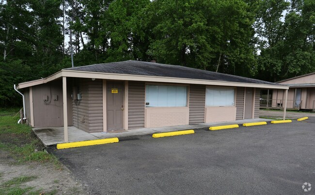
Property Detail
22722 Loop 494
0432030000090
TR 2K ABST 537 W MASSEY
Storebuilding
HARRIS
B and X Area of moderate flood hazard, usually the area between the limits of the 100-year and 500-year floods.
Texas
2024
0.96 AC
2025
Kingwood Area
251100
Houston
4,061 SF
Houston-Pasadena-The Woodlands, TX
NEARBY LISTINGS FOR SALE OR LEASE
DEMOGRAPHICS near 22722 Loop 494
1 mile
3 mile
5 mile
2025 Total Population
5,091
46,092
151,351
2030 Population
5,696
51,452
165,500
Pop Growth 2025-2030
+ 11.88%
+ 11.63%
+ 9.35%
Average Age
40
39
38
2025 Total Households
2,203
18,112
54,449
HH Growth 2025-2030
+ 13.30%
+ 12.60%
+ 9.94%
Median Household Inc
$74,773
$89,700
$86,560
Avg Household Size
2.20
2.50
2.70
2025 Avg HH Vehicles
2.00
2.00
2.00
Median Home Value
$269,128
$309,990
$279,699
Median Year Built
2004
2002
1997
Nearby Places
Map Layers
Map Styles
 Street
 Aerial
Layers
 Traffic
 Biking
Places
Listings with unknown addresses are not visible on the map
- Restaurants
- Banks
- Shops
- Fitness
- Groceries
PUBLIC TRANSPORTATION
AIRPORT
George Bush Intcntl/Houston
Drive
Walk
Distance
George Bush Intcntl/Houston
17 min
11.4 mi
William P Hobby
Drive
Walk
Distance
William P Hobby
49 min
33.0 mi
Freight Ports
Port of Houston
Drive
Walk
Distance
Port of Houston
38 min
26.7 mi
Nearby Properties
Address
Land Use
TOTAL SIZE
Lot Size
Zoning
Address
Land Use
TOTAL SIZE
Lot Size
Zoning
687,195 SF
33.75 AC
Address
Land Use
TOTAL SIZE
Lot Size
Zoning
633,347 SF
32.15 AC
5
Address
Land Use
TOTAL SIZE
Lot Size
Zoning
733,100 SF
28.18 AC
Address
Land Use
TOTAL SIZE
Lot Size
Zoning
604,908 SF
58.67 AC
Address
Land Use
TOTAL SIZE
Lot Size
Zoning
363,730 SF
12.59 AC
Address
Land Use
TOTAL SIZE
Lot Size
Zoning
275,500 SF
13.58 AC
Address
Land Use
TOTAL SIZE
Lot Size
Zoning
407,266 SF
25.02 AC
Address
Land Use
TOTAL SIZE
Lot Size
Zoning
288,199 SF
15.50 AC
Address
Land Use
TOTAL SIZE
Lot Size
Zoning
392,395 SF
14.86 AC
5
Address
Land Use
TOTAL SIZE
Lot Size
Zoning
316,815 SF
15.61 AC
Address
Land Use
TOTAL SIZE
Lot Size
Zoning
341,175 SF
65.76 AC
5
Address
Land Use
TOTAL SIZE
Lot Size
Zoning
327,725 SF
22.04 AC
5
Address
Land Use
TOTAL SIZE
Lot Size
Zoning
284,662 SF
14.60 AC
Address
Land Use
TOTAL SIZE
Lot Size
Zoning
374,791 SF
17.36 AC
Address
Land Use
TOTAL SIZE
Lot Size
Zoning
307,727 SF
14.93 AC
5
Address
Land Use
TOTAL SIZE
Lot Size
Zoning
343,814 SF
12.83 AC
Address
Land Use
TOTAL SIZE
Lot Size
Zoning
237,686 SF
6.53 AC
5
Address
Land Use
TOTAL SIZE
Lot Size
Zoning
201,363 SF
24.98 AC
5
Address
Land Use
TOTAL SIZE
Lot Size
Zoning
125,148 SF
10.73 AC
5
Address
Land Use
TOTAL SIZE
Lot Size
Zoning
194,418 SF
6.93 AC
Address
Land Use
TOTAL SIZE
Lot Size
Zoning
237,552 SF
13.28 AC
5
Address
Land Use
TOTAL SIZE
Lot Size
Zoning
269,585 SF
8.34 AC
Address
Land Use
TOTAL SIZE
Lot Size
Zoning
102,374 SF
13.48 AC
Address
Land Use
TOTAL SIZE
Lot Size
Zoning
156,756 SF
17.05 AC
Address
Land Use
TOTAL SIZE
Lot Size
Zoning
235,072 SF
26.44 AC
5
Address
Land Use
TOTAL SIZE
Lot Size
Zoning
256,120 SF
9.81 AC
Address
Land Use
TOTAL SIZE
Lot Size
Zoning
206,600 SF
23.09 AC
Address
Land Use
TOTAL SIZE
Lot Size
Zoning
128,976 SF
16.99 AC
Address
Land Use
TOTAL SIZE
Lot Size
Zoning
192,620 SF
7.46 AC
Address
Land Use
TOTAL SIZE
Lot Size
Zoning
132,930 SF
11.23 AC
The World's #1 Commercial Real Estate Marketplace
Connect with us
© 2026 CoStar Group
The information above has been obtained from sources believed reliable. While we do not doubt its accuracy we have not verified it and make no guarantee, warranty or representation about it. It is your responsibility to independently confirm its accuracy and completeness. Any projections, opinions, assumptions, or estimates used are for example only and do not represent the current or future performance of the property. The value of this transaction to you depends on tax and other factors which should be evaluated by your tax, financial, and legal advisors. You and your advisors should conduct a careful, independent investigation of the property to determine to your satisfaction the suitability of the property for your needs.