Property Record
22731 Fm 2920 Rd, Hockley, TX 77447
Property Detail
22731 Fm 2920 Rd
Houston-Pasadena-The Woodlands, TX
TRS 20A 25A 26A & 27A PT LTS 1 & 8 ABST 333 HARRIS CO SCH LDS 30
0422660000005
Harris
Warehouse
Texas
B and X Area of moderate flood hazard, usually the area between the limits of the 100-year and 500-year floods.
1,8
2024
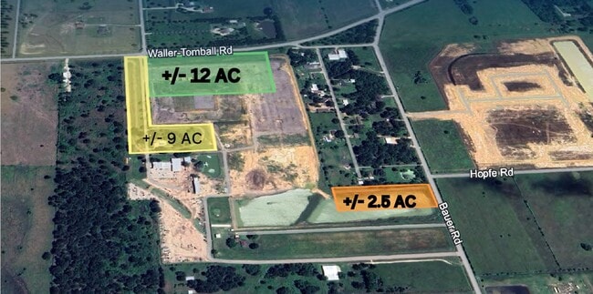
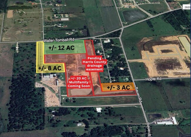
11.69 AC
2025
Northwest Outlier
556000
Houston
2,400 SF
NEARBY LISTINGS FOR SALE OR LEASE
DEMOGRAPHICS near 22731 Fm 2920 Rd
1 mile
3 mile
5 mile
2025 Total Population
2,409
14,565
51,539
2030 Population
2,733
16,517
57,243
Pop Growth 2025-2030
+ 13.45%
+ 13.40%
+ 11.07%
Average Age
35
35
37
2025 Total Households
717
4,508
16,350
HH Growth 2025-2030
+ 13.67%
+ 13.69%
+ 11.46%
Median Household Inc
$131,626
$114,401
$121,648
Avg Household Size
3.30
3.20
3.10
2025 Avg HH Vehicles
2.00
2.00
2.00
Median Home Value
$354,961
$325,936
$368,701
Median Year Built
2011
2011
2010
Nearby Places
Map Layers
Map Styles
 Street
 Aerial
Layers
 Traffic
 Biking
Places
Listings with unknown addresses are not visible on the map
- Restaurants
- Banks
- Shops
- Fitness
- Groceries
PUBLIC TRANSPORTATION
AIRPORT
George Bush Intcntl/Houston
Drive
Walk
Distance
George Bush Intcntl/Houston
49 min
36.8 mi
Freight Ports
Port of Houston
Drive
Walk
Distance
Port of Houston
64 min
46.5 mi
SALE & LEASE HISTORY
LISTING DATE
SALE/LEASE

Aug 29, 2019
For Sale
Apr 03, 2024
For Sale
Nearby Properties
Address
Land Use
TOTAL SIZE
Lot Size
Zoning
Address
Land Use
TOTAL SIZE
Lot Size
Zoning
1,463.22 AC
Address
Land Use
TOTAL SIZE
Lot Size
Zoning
280.90 AC
Address
Land Use
TOTAL SIZE
Lot Size
Zoning
55,800 SF
25.95 AC
Address
Land Use
TOTAL SIZE
Lot Size
Zoning
238.57 AC
Address
Land Use
TOTAL SIZE
Lot Size
Zoning
210.95 AC
Address
Land Use
TOTAL SIZE
Lot Size
Zoning
428.29 AC
Address
Land Use
TOTAL SIZE
Lot Size
Zoning
57,059 SF
83.47 AC
Address
Land Use
TOTAL SIZE
Lot Size
Zoning
157.95 AC
Address
Land Use
TOTAL SIZE
Lot Size
Zoning
467.86 AC
Address
Land Use
TOTAL SIZE
Lot Size
Zoning
17,359 SF
42.46 AC
Address
Land Use
TOTAL SIZE
Lot Size
Zoning
268 AC
Address
Land Use
TOTAL SIZE
Lot Size
Zoning
54,630 SF
4 AC
Address
Land Use
TOTAL SIZE
Lot Size
Zoning
97.91 AC
Address
Land Use
TOTAL SIZE
Lot Size
Zoning
24,324 SF
2.29 AC
Address
Land Use
TOTAL SIZE
Lot Size
Zoning
924 SF
96.75 AC
Address
Land Use
TOTAL SIZE
Lot Size
Zoning
9,600 SF
31.20 AC
Address
Land Use
TOTAL SIZE
Lot Size
Zoning
81.64 AC
Address
Land Use
TOTAL SIZE
Lot Size
Zoning
285.50 AC
Address
Land Use
TOTAL SIZE
Lot Size
Zoning
113.94 AC
Address
Land Use
TOTAL SIZE
Lot Size
Zoning
332.15 AC
Address
Land Use
TOTAL SIZE
Lot Size
Zoning
143.18 AC
Address
Land Use
TOTAL SIZE
Lot Size
Zoning
76.59 AC
Address
Land Use
TOTAL SIZE
Lot Size
Zoning
96,049 SF
2 AC
Address
Land Use
TOTAL SIZE
Lot Size
Zoning
63.85 AC
Address
Land Use
TOTAL SIZE
Lot Size
Zoning
63.85 AC
Address
Land Use
TOTAL SIZE
Lot Size
Zoning
10,680 SF
2.45 AC
Address
Land Use
TOTAL SIZE
Lot Size
Zoning
31,750 SF
6.79 AC
Address
Land Use
TOTAL SIZE
Lot Size
Zoning
3,840 SF
31.64 AC
Address
Land Use
TOTAL SIZE
Lot Size
Zoning
10.94 AC
Address
Land Use
TOTAL SIZE
Lot Size
Zoning
46,300 SF
7.29 AC
The World's #1 Commercial Real Estate Marketplace
Connect with us
© 2026 CoStar Group
The information above has been obtained from sources believed reliable. While we do not doubt its accuracy we have not verified it and make no guarantee, warranty or representation about it. It is your responsibility to independently confirm its accuracy and completeness. Any projections, opinions, assumptions, or estimates used are for example only and do not represent the current or future performance of the property. The value of this transaction to you depends on tax and other factors which should be evaluated by your tax, financial, and legal advisors. You and your advisors should conduct a careful, independent investigation of the property to determine to your satisfaction the suitability of the property for your needs.