Property Record
2274 S 1300 E, Salt Lake City, UT 84106


NEARBY LISTINGS FOR SALE OR LEASE
Property Detail
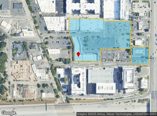
2274 S 1300 E
16-20-276-079-0000
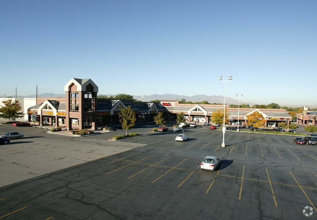
Sugarhouse Center Sub
Regionalshoppingcenterormallwithanchorstore
BEG S 89^3825 E 25.63 FT & S 0^0352 E 35.79 & N 89^5608 E 31.80 FT FT FR SE COR PARCEL 9G, SUGARHOUSE CENTER SUB #3; N 89^5713 E 102.51 FT; S 00^0352 E 3.00 FT N 89^5711 E 287.54 FT; S 0^2135 W 4.5 FT M OR L; S 89^3825 E 8.96 FT; S 0^2135 W 19.10 FT;
X
Salt Lake
49035C0301H
Utah
2024
7.33 AC
2025
Sugarhouse
114100
Salt Lake City
136,849 SF
Salt Lake City, UT
DEMOGRAPHICS near 2274 S 1300 E
1 Mile
3 Mile
5 Mile
2024 Total Population
19,924
154,714
331,129
2029 Population
20,204
156,483
335,693
Pop Growth 2024-2029
+ 1.41%
+ 1.14%
+ 1.38%
Average Age
38
37
38
2024 Total Households
9,152
66,702
139,472
HH Growth 2024-2029
+ 1.70%
+ 1.27%
+ 1.66%
Median Household Inc
$82,321
$71,027
$67,514
Avg Household Size
2.10
2.20
2.20
2024 Avg HH Vehicles
2.00
2.00
2.00
Median Home Value
$495,077
$541,898
$506,761
Median Year Built
1957
1963
1971
Nearby Places
Map Layers
Map Styles
 Street
 Aerial
- Restaurants
- Banks
- Shops
- Fitness
- Groceries
PUBLIC TRANSPORTATION
COMMUTER RAIL
Salt Lake Central Station (FrontRunner North - Utah Transit Authority (UTA), TRAX Salt Lake/Sandy Line - Utah Transit Authority (UTA), TRAX University Line - Utah Transit Authority (UTA))
DRIVE
WALK
Distance
Salt Lake Central Station (FrontRunner North - Utah Transit Authority (UTA), TRAX Salt Lake/Sandy Line - Utah Transit Authority (UTA), TRAX University Line - Utah Transit Authority (UTA))
10 min
6.7 mi
AIRPORT
Salt Lake City International
DRIVE
WALK
Distance
Salt Lake City International
13 min
11.3 mi
Freight Ports
Port of Oakland
DRIVE
WALK
Distance
Port of Oakland
1 min
592.8 mi
Nearby Properties
Address
Land Use
TOTAL SIZE
Lot Size
Zoning
Address
Land Use
TOTAL SIZE
Lot Size
Zoning
591,924 SF
80.77 AC
I
Address
Land Use
TOTAL SIZE
Lot Size
Zoning
1,262,865 SF
44.15 AC
I
Address
Land Use
TOTAL SIZE
Lot Size
Zoning
530,605 SF
127 AC
RP
Address
Land Use
TOTAL SIZE
Lot Size
Zoning
365,253 SF
33.64 AC
I
Address
Land Use
TOTAL SIZE
Lot Size
Zoning
298,628 SF
27.30 AC
I
Address
Land Use
TOTAL SIZE
Lot Size
Zoning
299,535 SF
38 AC
I
Address
Land Use
TOTAL SIZE
Lot Size
Zoning
254,939 SF
34.68 AC
I
Address
Land Use
TOTAL SIZE
Lot Size
Zoning
497,018 SF
13.11 AC
I
Address
Land Use
TOTAL SIZE
Lot Size
Zoning
163,932 SF
14.65 AC
PL
Address
Land Use
TOTAL SIZE
Lot Size
Zoning
95,666 SF
52.19 AC
I
Address
Land Use
TOTAL SIZE
Lot Size
Zoning
8,042 SF
64.58 AC
RP
Address
Land Use
TOTAL SIZE
Lot Size
Zoning
691,463 SF
17.80 AC
RM
Address
Land Use
TOTAL SIZE
Lot Size
Zoning
208,868 SF
20.41 AC
I
Address
Land Use
TOTAL SIZE
Lot Size
Zoning
183,600 SF
10.70 AC
RMF-35
Address
Land Use
TOTAL SIZE
Lot Size
Zoning
128,997 SF
3.04 AC
ESN
Address
Land Use
TOTAL SIZE
Lot Size
Zoning
297,476 SF
1.62 AC
CSHBD2
Address
Land Use
TOTAL SIZE
Lot Size
Zoning
549,074 SF
3.45 AC
D-1
Address
Land Use
TOTAL SIZE
Lot Size
Zoning
152,660 SF
5.40 AC
I
Address
Land Use
TOTAL SIZE
Lot Size
Zoning
680,751 SF
1.45 AC
TSA-UC
Address
Land Use
TOTAL SIZE
Lot Size
Zoning
369,717 SF
2.50 AC
RO
Address
Land Use
TOTAL SIZE
Lot Size
Zoning
502,104 SF
4.11 AC
E ST C
Address
Land Use
TOTAL SIZE
Lot Size
Zoning
412,006 SF
1.70 AC
C3
Address
Land Use
TOTAL SIZE
Lot Size
Zoning
371,963 SF
1.81 AC
R-MU
Address
Land Use
TOTAL SIZE
Lot Size
Zoning
369,377 SF
1.65 AC
Address
Land Use
TOTAL SIZE
Lot Size
Zoning
152,579 SF
25.45 AC
I
Address
Land Use
TOTAL SIZE
Lot Size
Zoning
426,600 SF
1.61 AC
CSHBD1
Address
Land Use
TOTAL SIZE
Lot Size
Zoning
95,854 SF
15.42 AC
CC
Address
Land Use
TOTAL SIZE
Lot Size
Zoning
903,167 SF
1.90 AC
CSHBD1
Address
Land Use
TOTAL SIZE
Lot Size
Zoning
191,876 SF
3.18 AC
TSAUNC
Address
Land Use
TOTAL SIZE
Lot Size
Zoning
33,164 SF
6.88 AC
RM
The World's #1 Commercial Real Estate Marketplace
Connect with us
© 2026 CoStar Group
The information above has been obtained from sources believed reliable. While we do not doubt its accuracy we have not verified it and make no guarantee, warranty or representation about it. It is your responsibility to independently confirm its accuracy and completeness. Any projections, opinions, assumptions, or estimates used are for example only and do not represent the current or future performance of the property. The value of this transaction to you depends on tax and other factors which should be evaluated by your tax, financial, and legal advisors. You and your advisors should conduct a careful, independent investigation of the property to determine to your satisfaction the suitability of the property for your needs.