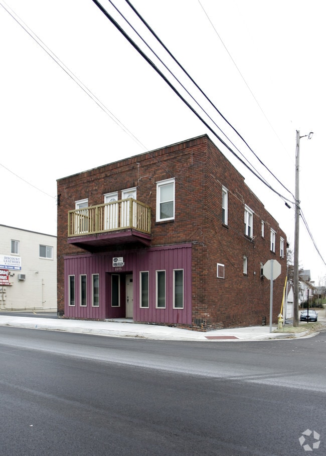
Property Record
2275 Manchester Rd, Akron, OH 44314
Property Detail
2275 Manchester Rd
Akron, OH
ALLENSIDE LOT 33 ALLALLENFORD FLORA AVE
68-36129
Summit
Storebuilding
Ohio
B and X Area of moderate flood hazard, usually the area between the limits of the 100-year and 500-year floods.
33
2023
0.11 AC
2025
Akron
505900
Cleveland
5,400 SF
NEARBY LISTINGS FOR SALE OR LEASE
DEMOGRAPHICS near 2275 Manchester Rd
1 mile
3 mile
5 mile
2025 Total Population
7,534
80,747
176,200
2030 Population
7,571
81,141
177,189
Pop Growth 2025-2030
+ 0.49%
+ 0.49%
+ 0.56%
Average Age
40
40
40
2025 Total Households
3,201
34,790
75,820
HH Growth 2025-2030
+ 0.47%
+ 0.43%
+ 0.52%
Median Household Inc
$46,231
$46,373
$46,677
Avg Household Size
2.30
2.20
2.20
2025 Avg HH Vehicles
2.00
2.00
2.00
Median Home Value
$95,386
$112,823
$133,102
Median Year Built
1948
1953
1953
Nearby Places
Map Layers
Map Styles
 Street
 Aerial
Layers
 Traffic
 Biking
Places
Listings with unknown addresses are not visible on the map
- Restaurants
- Banks
- Shops
- Fitness
- Groceries
PUBLIC TRANSPORTATION
COMMUTER RAIL
Drive
Walk
Distance
11 min
4.7 mi
Drive
Walk
Distance
17 min
7.3 mi
AIRPORT
Akron-Canton Regional
Drive
Walk
Distance
Akron-Canton Regional
18 min
12.4 mi
Cleveland-Hopkins International
Drive
Walk
Distance
Cleveland-Hopkins International
56 min
40.5 mi
Nearby Properties
Address
Land Use
TOTAL SIZE
Lot Size
Zoning
Address
Land Use
TOTAL SIZE
Lot Size
Zoning
1,397,532 SF
92.95 AC
Address
Land Use
TOTAL SIZE
Lot Size
Zoning
472,380 SF
4.55 AC
Address
Land Use
TOTAL SIZE
Lot Size
Zoning
203,458 SF
10.41 AC
Address
Land Use
TOTAL SIZE
Lot Size
Zoning
9.19 AC
Address
Land Use
TOTAL SIZE
Lot Size
Zoning
92,152 SF
1.69 AC
Address
Land Use
TOTAL SIZE
Lot Size
Zoning
132,611 SF
3.56 AC
Address
Land Use
TOTAL SIZE
Lot Size
Zoning
257,958 SF
4.64 AC
Address
Land Use
TOTAL SIZE
Lot Size
Zoning
91,678 SF
5.24 AC
Address
Land Use
TOTAL SIZE
Lot Size
Zoning
423,125 SF
5.57 AC
Address
Land Use
TOTAL SIZE
Lot Size
Zoning
3.16 AC
Address
Land Use
TOTAL SIZE
Lot Size
Zoning
227,634 SF
21.46 AC
Address
Land Use
TOTAL SIZE
Lot Size
Zoning
233,762 SF
3.56 AC
Address
Land Use
TOTAL SIZE
Lot Size
Zoning
2.20 AC
Address
Land Use
TOTAL SIZE
Lot Size
Zoning
184,791 SF
3.25 AC
Address
Land Use
TOTAL SIZE
Lot Size
Zoning
154,926 SF
12.38 AC
Address
Land Use
TOTAL SIZE
Lot Size
Zoning
127,297 SF
6.03 AC
Address
Land Use
TOTAL SIZE
Lot Size
Zoning
89,642 SF
0.69 AC
Address
Land Use
TOTAL SIZE
Lot Size
Zoning
Address
Land Use
TOTAL SIZE
Lot Size
Zoning
121,006 SF
6.09 AC
Address
Land Use
TOTAL SIZE
Lot Size
Zoning
97,322 SF
1.42 AC
Address
Land Use
TOTAL SIZE
Lot Size
Zoning
22,977 SF
263.47 AC
Address
Land Use
TOTAL SIZE
Lot Size
Zoning
57,180 SF
6.67 AC
Address
Land Use
TOTAL SIZE
Lot Size
Zoning
49,278 SF
1.25 AC
Address
Land Use
TOTAL SIZE
Lot Size
Zoning
123,800 SF
76.50 AC
Address
Land Use
TOTAL SIZE
Lot Size
Zoning
Address
Land Use
TOTAL SIZE
Lot Size
Zoning
148.10 AC
Address
Land Use
TOTAL SIZE
Lot Size
Zoning
51,520 SF
2.70 AC
Address
Land Use
TOTAL SIZE
Lot Size
Zoning
52,640 SF
0.42 AC
Address
Land Use
TOTAL SIZE
Lot Size
Zoning
126,708 SF
3.26 AC
Address
Land Use
TOTAL SIZE
Lot Size
Zoning
232,425 SF
13.37 AC
The World's #1 Commercial Real Estate Marketplace
Connect with us
© 2026 CoStar Group
The information above has been obtained from sources believed reliable. While we do not doubt its accuracy we have not verified it and make no guarantee, warranty or representation about it. It is your responsibility to independently confirm its accuracy and completeness. Any projections, opinions, assumptions, or estimates used are for example only and do not represent the current or future performance of the property. The value of this transaction to you depends on tax and other factors which should be evaluated by your tax, financial, and legal advisors. You and your advisors should conduct a careful, independent investigation of the property to determine to your satisfaction the suitability of the property for your needs.