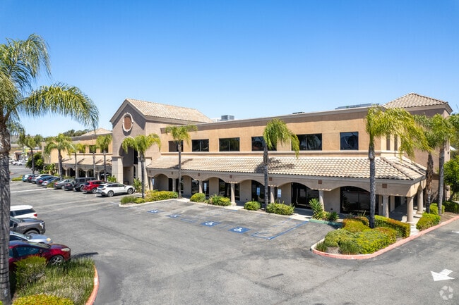
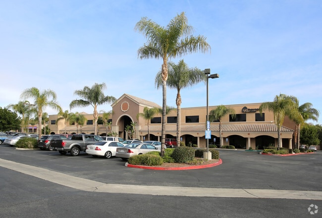
Property Record
2275 Sampson Ave, Corona, CA 92879

Current Lease Availabilities
Property Detail
2275 Sampson Ave
Riverside-San Bernardino-Ontario, CA
1.87 ACRES M/L IN POR LOT 16 MB 002/042 RIVERSIDE LAND CO FOOTHILL TR
172-420-005
Riverside
Officebuilding
California
C and X Area of minimal flood hazard, usually depicted on FIRMs as above the 500-year flood level.
16
2024
1.87 AC
2025
Corona/Eastvale
041412
Inland Empire (California)
30,693 SF
NEARBY LISTINGS FOR SALE OR LEASE
DEMOGRAPHICS near 2275 Sampson Ave
1 mile
3 mile
5 mile
2025 Total Population
22,773
100,117
272,896
2030 Population
23,280
101,927
277,652
Pop Growth 2025-2030
+ 2.23%
+ 1.81%
+ 1.74%
Average Age
37
37
37
2025 Total Households
6,764
29,892
77,374
HH Growth 2025-2030
+ 1.92%
+ 1.39%
+ 1.25%
Median Household Inc
$92,295
$94,366
$100,229
Avg Household Size
3.20
3.20
3.30
2025 Avg HH Vehicles
2.00
2.00
2.00
Median Home Value
$641,695
$680,873
$705,438
Median Year Built
1987
1986
1984
Nearby Places
Map Layers
Map Styles
 Street
 Aerial
Transit
 Traffic
 Biking
Places
Listings with unknown addresses are not visible on the map
- Restaurants
- Banks
- Shops
- Fitness
- Groceries
PUBLIC TRANSPORTATION
COMMUTER RAIL
Riverside-La Sierra (91 Line - Southern California Regional Rail Authority (Metrolink), Inland Empire-Orange County Line - Southern California Regional Rail Authority (Metrolink))
Drive
Walk
Distance
Riverside-La Sierra (91 Line - Southern California Regional Rail Authority (Metrolink), Inland Empire-Orange County Line - Southern California Regional Rail Authority (Metrolink))
7 min
3.3 mi
North Main Corona (91 Line - Southern California Regional Rail Authority (Metrolink), Inland Empire-Orange County Line - Southern California Regional Rail Authority (Metrolink))
Drive
Walk
Distance
North Main Corona (91 Line - Southern California Regional Rail Authority (Metrolink), Inland Empire-Orange County Line - Southern California Regional Rail Authority (Metrolink))
7 min
3.6 mi
AIRPORT
Ontario International
Drive
Walk
Distance
Ontario International
25 min
17.8 mi
John Wayne/Orange County
Drive
Walk
Distance
John Wayne/Orange County
39 min
31.4 mi
Nearby Properties
Address
Land Use
TOTAL SIZE
Lot Size
Zoning
Address
Land Use
TOTAL SIZE
Lot Size
Zoning
1,658,755 SF
37.05 AC
Address
Land Use
TOTAL SIZE
Lot Size
Zoning
167,068 SF
26.55 AC
Address
Land Use
TOTAL SIZE
Lot Size
Zoning
32,924 SF
24.04 AC
Address
Land Use
TOTAL SIZE
Lot Size
Zoning
12.69 AC
Address
Land Use
TOTAL SIZE
Lot Size
Zoning
76,546 SF
13.53 AC
R
Address
Land Use
TOTAL SIZE
Lot Size
Zoning
335,820 SF
15.18 AC
Address
Land Use
TOTAL SIZE
Lot Size
Zoning
205,235 SF
10.30 AC
Address
Land Use
TOTAL SIZE
Lot Size
Zoning
71,440 SF
14.37 AC
Address
Land Use
TOTAL SIZE
Lot Size
Zoning
289,297 SF
13.28 AC
M3
Address
Land Use
TOTAL SIZE
Lot Size
Zoning
186,190 SF
9.79 AC
Address
Land Use
TOTAL SIZE
Lot Size
Zoning
164,712 SF
10 AC
R3
Address
Land Use
TOTAL SIZE
Lot Size
Zoning
173,676 SF
10.96 AC
R3
Address
Land Use
TOTAL SIZE
Lot Size
Zoning
152,369 SF
5.38 AC
Address
Land Use
TOTAL SIZE
Lot Size
Zoning
8.80 AC
R3
Address
Land Use
TOTAL SIZE
Lot Size
Zoning
150,404 SF
8.02 AC
Address
Land Use
TOTAL SIZE
Lot Size
Zoning
20.08 AC
R020
Address
Land Use
TOTAL SIZE
Lot Size
Zoning
421,898 SF
3 AC
Address
Land Use
TOTAL SIZE
Lot Size
Zoning
115,545 SF
5.97 AC
Address
Land Use
TOTAL SIZE
Lot Size
Zoning
46,694 SF
7.16 AC
Address
Land Use
TOTAL SIZE
Lot Size
Zoning
171,707 SF
8.55 AC
Address
Land Use
TOTAL SIZE
Lot Size
Zoning
14 AC
R1
Address
Land Use
TOTAL SIZE
Lot Size
Zoning
149,389 SF
6.72 AC
Address
Land Use
TOTAL SIZE
Lot Size
Zoning
359,304 SF
8.86 AC
R3
Address
Land Use
TOTAL SIZE
Lot Size
Zoning
152,756 SF
7.07 AC
Address
Land Use
TOTAL SIZE
Lot Size
Zoning
52,928 SF
9.69 AC
Address
Land Use
TOTAL SIZE
Lot Size
Zoning
138,800 SF
10 AC
M4
Address
Land Use
TOTAL SIZE
Lot Size
Zoning
129,911 SF
6.10 AC
Address
Land Use
TOTAL SIZE
Lot Size
Zoning
364,162 SF
10 AC
M4
The World's #1 Commercial Real Estate Marketplace
Connect with us
© 2026 CoStar Group
The information above has been obtained from sources believed reliable. While we do not doubt its accuracy we have not verified it and make no guarantee, warranty or representation about it. It is your responsibility to independently confirm its accuracy and completeness. Any projections, opinions, assumptions, or estimates used are for example only and do not represent the current or future performance of the property. The value of this transaction to you depends on tax and other factors which should be evaluated by your tax, financial, and legal advisors. You and your advisors should conduct a careful, independent investigation of the property to determine to your satisfaction the suitability of the property for your needs.