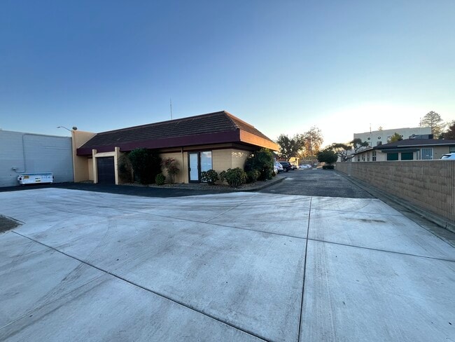
Property Record
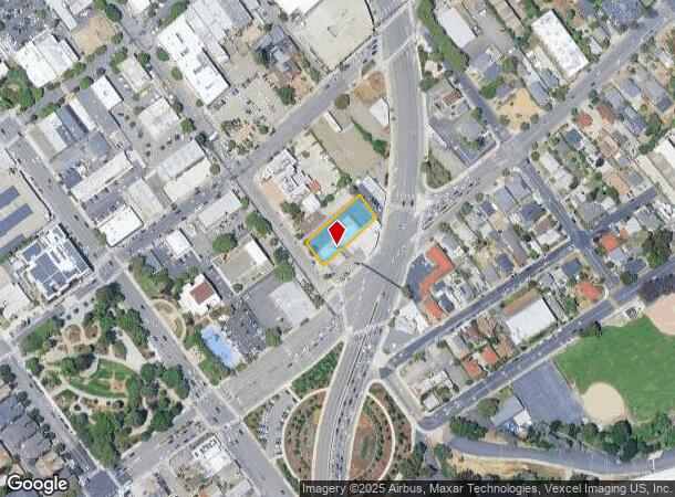
22770 Main St, Hayward, CA 94541
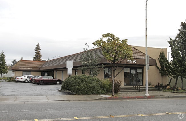

This Property Is For Sale
NEARBY LISTINGS FOR SALE OR LEASE
Property Detail
22770 Main St
428-0066-069-01
Tract 3780
Officebuilding
LOT: 00001 BLK: AR: 0085 PAGE: 0700 ;LOT: 00001 BLK: TR: 2637 ;LOT: 00001 BLK: 0069 AR: 0428 PAGE: 0066
X
Alameda
06001C0287G
California
2024
0.37 AC
2025
Hayward/Castro Valley
435400
East Bay/Oakland
4,617 SF
Oakland-Fremont-Berkeley, CA
DEMOGRAPHICS near 22770 Main St
1 mile
3 mile
5 mile
2024 Total Population
31,909
222,482
343,748
2029 Population
31,053
215,023
332,256
Pop Growth 2024-2029
(2.68%)
(3.35%)
(3.34%)
Average Age
39
39
40
2024 Total Households
11,160
71,153
110,646
HH Growth 2024-2029
(2.80%)
(3.53%)
(3.53%)
Median Household Inc
$93,559
$96,291
$97,869
Avg Household Size
2.70
3.00
3.00
2024 Avg HH Vehicles
2.00
2.00
2.00
Median Home Value
$713,961
$767,781
$773,775
Median Year Built
1970
1966
1967
Nearby Places
Map Layers
Map Styles
 Street
 Aerial
Transit
 Traffic
 Biking
Places
Listings with unknown addresses are not visible on the map
- Restaurants
- Banks
- Shops
- Fitness
- Groceries
PUBLIC TRANSPORTATION
TRANSIT/SUBWAY
Hayward Station (Fremont - Daly City - Bay Area Rapid Transit (BART), Fremont - Richmond - Bay Area Rapid Transit (BART))
Drive
Walk
Distance
Hayward Station (Fremont - Daly City - Bay Area Rapid Transit (BART), Fremont - Richmond - Bay Area Rapid Transit (BART))
2 min
8 min
0.4 mi
COMMUTER RAIL
Drive
Walk
Distance
4 min
1.4 mi
Drive
Walk
Distance
4 min
1.4 mi
AIRPORT
Metro Oakland International
Drive
Walk
Distance
Metro Oakland International
16 min
10.6 mi
San Francisco International
Drive
Walk
Distance
San Francisco International
31 min
23.0 mi
Norman Y Mineta San Jose International
Drive
Walk
Distance
Norman Y Mineta San Jose International
36 min
27.5 mi
Nearby Properties
Address
Land Use
TOTAL SIZE
Lot Size
Zoning
Address
Land Use
TOTAL SIZE
Lot Size
Zoning
710,091 SF
50.34 AC
Address
Land Use
TOTAL SIZE
Lot Size
Zoning
4.90 AC
Address
Land Use
TOTAL SIZE
Lot Size
Zoning
240,556 SF
11.63 AC
Address
Land Use
TOTAL SIZE
Lot Size
Zoning
2.48 AC
Address
Land Use
TOTAL SIZE
Lot Size
Zoning
200,451 SF
11.22 AC
Address
Land Use
TOTAL SIZE
Lot Size
Zoning
236,976 SF
18.36 AC
Address
Land Use
TOTAL SIZE
Lot Size
Zoning
173,948 SF
6.10 AC
Address
Land Use
TOTAL SIZE
Lot Size
Zoning
175,325 SF
2.91 AC
Address
Land Use
TOTAL SIZE
Lot Size
Zoning
470,929 SF
31.62 AC
Address
Land Use
TOTAL SIZE
Lot Size
Zoning
1.50 AC
Address
Land Use
TOTAL SIZE
Lot Size
Zoning
150,856 SF
5.99 AC
Address
Land Use
TOTAL SIZE
Lot Size
Zoning
187,926 SF
1.19 AC
Address
Land Use
TOTAL SIZE
Lot Size
Zoning
160,987 SF
7.20 AC
Address
Land Use
TOTAL SIZE
Lot Size
Zoning
297,592 SF
11.65 AC
Address
Land Use
TOTAL SIZE
Lot Size
Zoning
310,072 SF
14.96 AC
Address
Land Use
TOTAL SIZE
Lot Size
Zoning
228,736 SF
5.95 AC
Address
Land Use
TOTAL SIZE
Lot Size
Zoning
169,371 SF
4.63 AC
Address
Land Use
TOTAL SIZE
Lot Size
Zoning
116,485 SF
1.81 AC
Address
Land Use
TOTAL SIZE
Lot Size
Zoning
137,889 SF
18.44 AC
Address
Land Use
TOTAL SIZE
Lot Size
Zoning
116,750 SF
4.72 AC
Address
Land Use
TOTAL SIZE
Lot Size
Zoning
253,812 SF
14.49 AC
Address
Land Use
TOTAL SIZE
Lot Size
Zoning
140,850 SF
9.98 AC
Address
Land Use
TOTAL SIZE
Lot Size
Zoning
89,968 SF
5 AC
Address
Land Use
TOTAL SIZE
Lot Size
Zoning
329,346 SF
29.36 AC
Address
Land Use
TOTAL SIZE
Lot Size
Zoning
119,800 SF
5.72 AC
Address
Land Use
TOTAL SIZE
Lot Size
Zoning
57,497 SF
4.92 AC
Address
Land Use
TOTAL SIZE
Lot Size
Zoning
84,690 SF
6.25 AC
CN
Address
Land Use
TOTAL SIZE
Lot Size
Zoning
120,441 SF
1.34 AC
Address
Land Use
TOTAL SIZE
Lot Size
Zoning
152,950 SF
4.96 AC
Address
Land Use
TOTAL SIZE
Lot Size
Zoning
115,648 SF
11.19 AC
The World's #1 Commercial Real Estate Marketplace
Connect with us
© 2026 CoStar Group
The information above has been obtained from sources believed reliable. While we do not doubt its accuracy we have not verified it and make no guarantee, warranty or representation about it. It is your responsibility to independently confirm its accuracy and completeness. Any projections, opinions, assumptions, or estimates used are for example only and do not represent the current or future performance of the property. The value of this transaction to you depends on tax and other factors which should be evaluated by your tax, financial, and legal advisors. You and your advisors should conduct a careful, independent investigation of the property to determine to your satisfaction the suitability of the property for your needs.