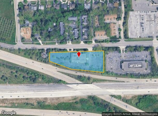
Property Record
22777 W 11 Mile Rd, Southfield, MI 48033
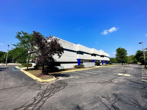

This Property Is For Sale
NEARBY LISTINGS FOR SALE OR LEASE
Property Detail
22777 W 11 Mile Rd
24-21-201-010
T1N,R10E,SEC 21 PART OF NE 1/4 BEG AT PT DIST S 88-05-24 W 1382.70 FT & S 00-32-06 E 60.02 FT FROM NE SEC COR, TH S 00-32-06
Medicalbuilding
Oakland
X
Michigan
26163C0060E
2.49 AC
2023
Southfield
2022
Detroit
160800
Detroit-Warren-Dearborn, MI
28,668 SF
DEMOGRAPHICS near 22777 W 11 Mile Rd
1 Mile
3 Mile
5 Mile
2024 Total Population
8,952
67,481
255,502
2029 Population
8,874
66,687
251,930
Pop Growth 2024-2029
(0.87%)
(1.18%)
(1.40%)
Average Age
46
44
42
2024 Total Households
4,390
29,866
108,289
HH Growth 2024-2029
(0.75%)
(1.16%)
(1.37%)
Median Household Inc
$59,394
$70,227
$68,465
Avg Household Size
2.00
2.20
2.30
2024 Avg HH Vehicles
1.00
2.00
2.00
Median Home Value
$233,460
$233,469
$230,043
Median Year Built
1971
1968
1960
Nearby Places
Map Layers
Map Styles
 Street
 Aerial
- Restaurants
- Banks
- Shops
- Fitness
- Groceries
PUBLIC TRANSPORTATION
COMMUTER RAIL
DRIVE
WALK
Distance
12 min
7.9 mi
DRIVE
WALK
Distance
18 min
8.8 mi
AIRPORT
Windsor International
DRIVE
WALK
Distance
Windsor International
47 min
26.5 mi
Detroit Metro Wayne County
DRIVE
WALK
Distance
Detroit Metro Wayne County
42 min
27.3 mi
Nearby Properties
Address
Land Use
TOTAL SIZE
Lot Size
Zoning
Address
Land Use
TOTAL SIZE
Lot Size
Zoning
2,373,792 SF
17.35 AC
RC
Address
Land Use
TOTAL SIZE
Lot Size
Zoning
350,140 SF
37.78 AC
RC
Address
Land Use
TOTAL SIZE
Lot Size
Zoning
882,862 SF
8.22 AC
RC
Address
Land Use
TOTAL SIZE
Lot Size
Zoning
588 SF
53.02 AC
RM
Address
Land Use
TOTAL SIZE
Lot Size
Zoning
460,062 SF
10.01 AC
RC
Address
Land Use
TOTAL SIZE
Lot Size
Zoning
544,945 SF
23.89 AC
BI
Address
Land Use
TOTAL SIZE
Lot Size
Zoning
592,350 SF
23.64 AC
RC
Address
Land Use
TOTAL SIZE
Lot Size
Zoning
535,287 SF
9.26 AC
RC
Address
Land Use
TOTAL SIZE
Lot Size
Zoning
383,602 SF
36.60 AC
I-1
Address
Land Use
TOTAL SIZE
Lot Size
Zoning
859,104 SF
9.59 AC
RC
Address
Land Use
TOTAL SIZE
Lot Size
Zoning
439,171 SF
28.57 AC
RMM
Address
Land Use
TOTAL SIZE
Lot Size
Zoning
261,633 SF
12.19 AC
RMM
Address
Land Use
TOTAL SIZE
Lot Size
Zoning
655,519 SF
9.18 AC
ERO
Address
Land Use
TOTAL SIZE
Lot Size
Zoning
170,465 SF
4.84 AC
BV
Address
Land Use
TOTAL SIZE
Lot Size
Zoning
228,544 SF
35.02 AC
BI
Address
Land Use
TOTAL SIZE
Lot Size
Zoning
17.19 AC
RC
Address
Land Use
TOTAL SIZE
Lot Size
Zoning
280,500 SF
3.58 AC
RC
Address
Land Use
TOTAL SIZE
Lot Size
Zoning
350,140 SF
27.11 AC
RC
Address
Land Use
TOTAL SIZE
Lot Size
Zoning
248,911 SF
4.55 AC
RC
Address
Land Use
TOTAL SIZE
Lot Size
Zoning
233,598 SF
17.24 AC
RS
Address
Land Use
TOTAL SIZE
Lot Size
Zoning
301,269 SF
25.47 AC
OS
Address
Land Use
TOTAL SIZE
Lot Size
Zoning
405,020 SF
18.74 AC
RMM
Address
Land Use
TOTAL SIZE
Lot Size
Zoning
367,101 SF
37.77 AC
R-E
Address
Land Use
TOTAL SIZE
Lot Size
Zoning
344,960 SF
8.90 AC
RC
Address
Land Use
TOTAL SIZE
Lot Size
Zoning
213,135 SF
6.17 AC
RC
Address
Land Use
TOTAL SIZE
Lot Size
Zoning
325,654 SF
7.45 AC
ERO
Address
Land Use
TOTAL SIZE
Lot Size
Zoning
181,954 SF
Address
Land Use
TOTAL SIZE
Lot Size
Zoning
306,250 SF
14.60 AC
RC
Address
Land Use
TOTAL SIZE
Lot Size
Zoning
280,984 SF
11.88 AC
ERO-M
Address
Land Use
TOTAL SIZE
Lot Size
Zoning
209,000 SF
11.21 AC
ERO
The World's #1 Commercial Real Estate Marketplace
Connect with us
© 2025 CoStar Group
The information above has been obtained from sources believed reliable. While we do not doubt its accuracy we have not verified it and make no guarantee, warranty or representation about it. It is your responsibility to independently confirm its accuracy and completeness. Any projections, opinions, assumptions, or estimates used are for example only and do not represent the current or future performance of the property. The value of this transaction to you depends on tax and other factors which should be evaluated by your tax, financial, and legal advisors. You and your advisors should conduct a careful, independent investigation of the property to determine to your satisfaction the suitability of the property for your needs.