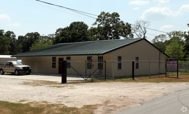
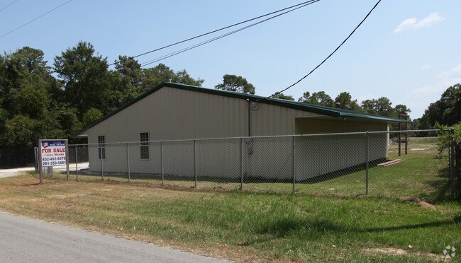
Property Record
22782 E Oakley Dr, New Caney, TX 77357

Save to a Folder
{{folder.Name}}
{{folder.ListingIds.length}} Properties
{{folder.ListingIds.length}} Property
Create a New Folder
Property Detail
22782 E Oakley Dr
0540-00-12305
A0540 - SMITH WM, TRACT 123, 123-A, ACRES 2.5
Commercialnec
Montgomery
5
Texas
AE The base floodplain where base flood elevations are provided. AE Zones are now used on new format FIRMs instead of A1-A30 Zones.
2.50 AC
2024
Kingwood/Humble
2025
Houston
692501
Houston-Pasadena-The Woodlands, TX
3,350 SF
NEARBY LISTINGS FOR SALE OR LEASE
DEMOGRAPHICS near 22782 E Oakley Dr
1 mile
3 mile
5 mile
2025 Total Population
5,046
42,089
126,351
2030 Population
5,940
49,356
144,549
Pop Growth 2025-2030
+ 17.72%
+ 17.27%
+ 14.40%
Average Age
34
36
37
2025 Total Households
1,610
14,289
43,966
HH Growth 2025-2030
+ 18.32%
+ 17.89%
+ 14.90%
Median Household Inc
$61,020
$78,678
$93,117
Avg Household Size
3.00
2.90
2.80
2025 Avg HH Vehicles
2.00
2.00
2.00
Median Home Value
$213,842
$253,075
$296,090
Median Year Built
1999
2006
2002
Nearby Places
Map Layers
Map Styles
 Street
 Aerial
Layers
 Traffic
 Biking
Places
Listings with unknown addresses are not visible on the map
- Restaurants
- Banks
- Shops
- Fitness
- Groceries
PUBLIC TRANSPORTATION
AIRPORT
George Bush Intcntl/Houston
Drive
Walk
Distance
George Bush Intcntl/Houston
25 min
17.9 mi
Freight Ports
Port of Houston
Drive
Walk
Distance
Port of Houston
47 min
33.2 mi
Nearby Properties
Address
Land Use
TOTAL SIZE
Lot Size
Zoning
Address
Land Use
TOTAL SIZE
Lot Size
Zoning
430,982 SF
21.50 AC
Address
Land Use
TOTAL SIZE
Lot Size
Zoning
298,715 SF
16.28 AC
Address
Land Use
TOTAL SIZE
Lot Size
Zoning
444,537 SF
55.21 AC
5
Address
Land Use
TOTAL SIZE
Lot Size
Zoning
274,809 SF
11.89 AC
Address
Land Use
TOTAL SIZE
Lot Size
Zoning
29,782 SF
28.69 AC
Address
Land Use
TOTAL SIZE
Lot Size
Zoning
282,880 SF
12.34 AC
Address
Land Use
TOTAL SIZE
Lot Size
Zoning
154,584 SF
46.76 AC
Address
Land Use
TOTAL SIZE
Lot Size
Zoning
161,302 SF
60.09 AC
5
Address
Land Use
TOTAL SIZE
Lot Size
Zoning
187,696 SF
20.07 AC
Address
Land Use
TOTAL SIZE
Lot Size
Zoning
215,554 SF
20.89 AC
5
Address
Land Use
TOTAL SIZE
Lot Size
Zoning
76,292 SF
32.01 AC
5
Address
Land Use
TOTAL SIZE
Lot Size
Zoning
165,381 SF
16.60 AC
Address
Land Use
TOTAL SIZE
Lot Size
Zoning
190,424 SF
23 AC
Address
Land Use
TOTAL SIZE
Lot Size
Zoning
224,810 SF
21.64 AC
5
Address
Land Use
TOTAL SIZE
Lot Size
Zoning
38,994 SF
4.82 AC
5
Address
Land Use
TOTAL SIZE
Lot Size
Zoning
121,871 SF
12.59 AC
Address
Land Use
TOTAL SIZE
Lot Size
Zoning
139,838 SF
38.71 AC
Address
Land Use
TOTAL SIZE
Lot Size
Zoning
131,364 SF
4.63 AC
5
Address
Land Use
TOTAL SIZE
Lot Size
Zoning
82,740 SF
5.25 AC
5
Address
Land Use
TOTAL SIZE
Lot Size
Zoning
131,028 SF
9.46 AC
Address
Land Use
TOTAL SIZE
Lot Size
Zoning
98,481 SF
27.47 AC
Address
Land Use
TOTAL SIZE
Lot Size
Zoning
51,659 SF
8.81 AC
Address
Land Use
TOTAL SIZE
Lot Size
Zoning
113,545 SF
10.70 AC
Address
Land Use
TOTAL SIZE
Lot Size
Zoning
109,704 SF
26.81 AC
Address
Land Use
TOTAL SIZE
Lot Size
Zoning
128,724 SF
29.89 AC
Address
Land Use
TOTAL SIZE
Lot Size
Zoning
23.03 AC
5
Address
Land Use
TOTAL SIZE
Lot Size
Zoning
110,013 SF
13.91 AC
5
Address
Land Use
TOTAL SIZE
Lot Size
Zoning
117,146 SF
8.25 AC
5
Address
Land Use
TOTAL SIZE
Lot Size
Zoning
90,142 SF
10.80 AC
5
The World's #1 Commercial Real Estate Marketplace
Connect with us
© 2026 CoStar Group
The information above has been obtained from sources believed reliable. While we do not doubt its accuracy we have not verified it and make no guarantee, warranty or representation about it. It is your responsibility to independently confirm its accuracy and completeness. Any projections, opinions, assumptions, or estimates used are for example only and do not represent the current or future performance of the property. The value of this transaction to you depends on tax and other factors which should be evaluated by your tax, financial, and legal advisors. You and your advisors should conduct a careful, independent investigation of the property to determine to your satisfaction the suitability of the property for your needs.