Property Record
228 Cornelia St, Boonton, NJ 07005


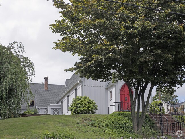
Property Detail
228 Cornelia St
Newark, NJ
FACILITY NAME: CHURCH
01-00010-0000-00007
MORRIS
Religious
New Jersey
R-3A
7
0
0.38 AC
2025
Parsippany
041100
Northern New Jersey
2,904 SF
NEARBY LISTINGS FOR SALE OR LEASE
-
-
View all Boonton listings for sale on LoopNet.com
DEMOGRAPHICS near 228 Cornelia St
1 mile
3 mile
5 mile
2025 Total Population
9,432
52,136
110,160
2030 Population
9,607
53,500
113,132
Pop Growth 2025-2030
+ 1.86%
+ 2.62%
+ 2.70%
Average Age
42
42
43
2025 Total Households
3,624
19,986
40,557
HH Growth 2025-2030
+ 1.93%
+ 2.68%
+ 2.75%
Median Household Inc
$113,253
$124,695
$137,080
Avg Household Size
2.50
2.50
2.60
2025 Avg HH Vehicles
2.00
2.00
2.00
Median Home Value
$532,888
$647,713
$636,565
Median Year Built
1958
1967
1967
Nearby Places
Map Layers
Map Styles
 Street
 Aerial
Layers
 Traffic
 Biking
Places
Listings with unknown addresses are not visible on the map
- Restaurants
- Banks
- Shops
- Fitness
- Groceries
PUBLIC TRANSPORTATION
COMMUTER RAIL
Boonton (Montclair-Boonton Line - NJ Transit Commuter Rail (NJ Transit))
Drive
Walk
Distance
Boonton (Montclair-Boonton Line - NJ Transit Commuter Rail (NJ Transit))
1 min
7 min
0.4 mi
Mountain Lakes (Montclair-Boonton Line - NJ Transit Commuter Rail (NJ Transit))
Drive
Walk
Distance
Mountain Lakes (Montclair-Boonton Line - NJ Transit Commuter Rail (NJ Transit))
7 min
3.1 mi
AIRPORT
Newark Liberty International
Drive
Walk
Distance
Newark Liberty International
36 min
28.1 mi
LaGuardia
Drive
Walk
Distance
LaGuardia
57 min
43.0 mi
Freight Ports
Maher Terminal
Drive
Walk
Distance
Maher Terminal
39 min
28.6 mi
Nearby Properties
Address
Land Use
TOTAL SIZE
Lot Size
Zoning
Address
Land Use
TOTAL SIZE
Lot Size
Zoning
98,228 SF
16.66 AC
I-1
Address
Land Use
TOTAL SIZE
Lot Size
Zoning
3.86 AC
O-3
Address
Land Use
TOTAL SIZE
Lot Size
Zoning
32.61 AC
R-5
Address
Land Use
TOTAL SIZE
Lot Size
Zoning
16.01 AC
R-C
Address
Land Use
TOTAL SIZE
Lot Size
Zoning
1,440 SF
38.80 AC
I-2
Address
Land Use
TOTAL SIZE
Lot Size
Zoning
140,560 SF
49.81 AC
R27A
Address
Land Use
TOTAL SIZE
Lot Size
Zoning
Address
Land Use
TOTAL SIZE
Lot Size
Zoning
26.65 AC
AHD7
Address
Land Use
TOTAL SIZE
Lot Size
Zoning
100,392 SF
19.18 AC
B-1
Address
Land Use
TOTAL SIZE
Lot Size
Zoning
4,172 SF
338 AC
R-1
Address
Land Use
TOTAL SIZE
Lot Size
Zoning
132,411 SF
24.87 AC
B-5
Address
Land Use
TOTAL SIZE
Lot Size
Zoning
17.33 AC
R-5
Address
Land Use
TOTAL SIZE
Lot Size
Zoning
10.80 AC
R-5
Address
Land Use
TOTAL SIZE
Lot Size
Zoning
4.99 AC
OB
Address
Land Use
TOTAL SIZE
Lot Size
Zoning
171,032 SF
12.93 AC
POD
Address
Land Use
TOTAL SIZE
Lot Size
Zoning
4.02 AC
R-3
Address
Land Use
TOTAL SIZE
Lot Size
Zoning
11.52 AC
R-5
Address
Land Use
TOTAL SIZE
Lot Size
Zoning
184,993 SF
8.38 AC
POD
Address
Land Use
TOTAL SIZE
Lot Size
Zoning
13,971 SF
16.12 AC
B-1
Address
Land Use
TOTAL SIZE
Lot Size
Zoning
179,144 SF
40.54 AC
R-3
Address
Land Use
TOTAL SIZE
Lot Size
Zoning
Address
Land Use
TOTAL SIZE
Lot Size
Zoning
211,848 SF
18.57 AC
POD
Address
Land Use
TOTAL SIZE
Lot Size
Zoning
41.21 AC
R-A
Address
Land Use
TOTAL SIZE
Lot Size
Zoning
8.80 AC
L
Address
Land Use
TOTAL SIZE
Lot Size
Zoning
11.07 AC
R-5
Address
Land Use
TOTAL SIZE
Lot Size
Zoning
10.46 AC
R-3
Address
Land Use
TOTAL SIZE
Lot Size
Zoning
11.57 AC
R-5
Address
Land Use
TOTAL SIZE
Lot Size
Zoning
225,092 SF
16.83 AC
POD
Address
Land Use
TOTAL SIZE
Lot Size
Zoning
10 AC
RASH
Address
Land Use
TOTAL SIZE
Lot Size
Zoning
50,948 SF
5.60 AC
C-1
The World's #1 Commercial Real Estate Marketplace
Connect with us
© 2026 CoStar Group
The information above has been obtained from sources believed reliable. While we do not doubt its accuracy we have not verified it and make no guarantee, warranty or representation about it. It is your responsibility to independently confirm its accuracy and completeness. Any projections, opinions, assumptions, or estimates used are for example only and do not represent the current or future performance of the property. The value of this transaction to you depends on tax and other factors which should be evaluated by your tax, financial, and legal advisors. You and your advisors should conduct a careful, independent investigation of the property to determine to your satisfaction the suitability of the property for your needs.