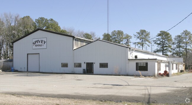
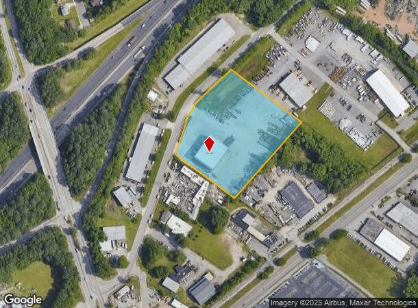
Property Record
228 Salters Creek Rd, Hampton, VA 23661

NEARBY LISTINGS FOR SALE OR LEASE
Property Detail
228 Salters Creek Rd
1000741
600000
Loftbuilding
228 SALTERS CREEK RD 4.3051AC
X
Hampton City
5155270024H
Virginia
2025
4.31 AC
2025
Copeland
010504
Hampton Roads
12,000 SF
Virginia Beach-Chesapeake-Norfolk, VA-NC
DEMOGRAPHICS near 228 Salters Creek Rd
1 mile
3 mile
5 mile
2024 Total Population
10,013
88,888
161,525
2029 Population
10,260
90,533
163,872
Pop Growth 2024-2029
+ 2.47%
+ 1.85%
+ 1.45%
Average Age
41
38
39
2024 Total Households
4,272
38,413
68,369
HH Growth 2024-2029
+ 2.46%
+ 1.85%
+ 1.45%
Median Household Inc
$56,523
$48,381
$52,989
Avg Household Size
2.30
2.20
2.30
2024 Avg HH Vehicles
2.00
2.00
2.00
Median Home Value
$178,072
$181,603
$198,339
Median Year Built
1965
1968
1969
Nearby Places
Map Layers
Map Styles
 Street
 Aerial
Transit
 Traffic
 Biking
Places
Listings with unknown addresses are not visible on the map
- Restaurants
- Banks
- Shops
- Fitness
- Groceries
PUBLIC TRANSPORTATION
COMMUTER RAIL
Drive
Walk
Distance
12 min
5.8 mi
AIRPORT
Newport News/Williamsburg International
Drive
Walk
Distance
Newport News/Williamsburg International
20 min
12.7 mi
Norfolk International
Drive
Walk
Distance
Norfolk International
29 min
18.7 mi
Freight Ports
Virginia Port Authority - Newport News
Drive
Walk
Distance
Virginia Port Authority - Newport News
8 min
4.4 mi
Nearby Properties
Address
Land Use
TOTAL SIZE
Lot Size
Zoning
Address
Land Use
TOTAL SIZE
Lot Size
Zoning
1 SF
92.67 AC
5 R-13 ONE
Address
Land Use
TOTAL SIZE
Lot Size
Zoning
83.50 AC
5 R-13 ONE
Address
Land Use
TOTAL SIZE
Lot Size
Zoning
347,560 SF
31.84 AC
14 C-2 LIM
Address
Land Use
TOTAL SIZE
Lot Size
Zoning
249,628 SF
52.71 AC
14 C-2 LIM
Address
Land Use
TOTAL SIZE
Lot Size
Zoning
112,089 SF
11.95 AC
30 DT-3 DO
Address
Land Use
TOTAL SIZE
Lot Size
Zoning
199,364 SF
22.12 AC
6 R-11 ONE
Address
Land Use
TOTAL SIZE
Lot Size
Zoning
35,550 SF
23.07 AC
14 C-2 LIM
Address
Land Use
TOTAL SIZE
Lot Size
Zoning
45,076 SF
9.53 AC
11 MD-4 MU
Address
Land Use
TOTAL SIZE
Lot Size
Zoning
19,328 SF
15.14 AC
14 C-2 LIM
Address
Land Use
TOTAL SIZE
Lot Size
Zoning
540,444 SF
33.66 AC
32 M-2 LIG
Address
Land Use
TOTAL SIZE
Lot Size
Zoning
248,956 SF
12.80 AC
14 C-2 LIM
Address
Land Use
TOTAL SIZE
Lot Size
Zoning
230,974 SF
42.68 AC
5 R-13 ONE
Address
Land Use
TOTAL SIZE
Lot Size
Zoning
88,941 SF
29.32 AC
11 MD-4 MU
Address
Land Use
TOTAL SIZE
Lot Size
Zoning
100 SF
35.50 AC
R7
Address
Land Use
TOTAL SIZE
Lot Size
Zoning
260,228 SF
37.04 AC
M1
Address
Land Use
TOTAL SIZE
Lot Size
Zoning
17,368 SF
7.08 AC
11 MD-4 MU
Address
Land Use
TOTAL SIZE
Lot Size
Zoning
7,053 SF
12.28 AC
14 C-2 LIM
Address
Land Use
TOTAL SIZE
Lot Size
Zoning
7,720 SF
9.91 AC
14 C-2 LIM
Address
Land Use
TOTAL SIZE
Lot Size
Zoning
100 SF
26.21 AC
R7
Address
Land Use
TOTAL SIZE
Lot Size
Zoning
286,173 SF
10 AC
14 C-2 LIM
Address
Land Use
TOTAL SIZE
Lot Size
Zoning
60,350 SF
27.53 AC
M1
Address
Land Use
TOTAL SIZE
Lot Size
Zoning
255,906 SF
36.57 AC
P1
Address
Land Use
TOTAL SIZE
Lot Size
Zoning
15,606 SF
12.07 AC
14 C-2 LIM
Address
Land Use
TOTAL SIZE
Lot Size
Zoning
34,222 SF
2.11 AC
14 C-2 LIM
Address
Land Use
TOTAL SIZE
Lot Size
Zoning
355,300 SF
19.03 AC
9 R-M MULT
Address
Land Use
TOTAL SIZE
Lot Size
Zoning
73,668 SF
3.24 AC
30 DT-3 DO
Address
Land Use
TOTAL SIZE
Lot Size
Zoning
51,372 SF
5.99 AC
14 C-2 LIM
Address
Land Use
TOTAL SIZE
Lot Size
Zoning
110,080 SF
2.21 AC
29 DT-2 DO
Address
Land Use
TOTAL SIZE
Lot Size
Zoning
458,744 SF
28.01 AC
17 M-3 HEA
Address
Land Use
TOTAL SIZE
Lot Size
Zoning
168,850 SF
1.02 AC
14 C-2 LIM
The World's #1 Commercial Real Estate Marketplace
Connect with us
© 2026 CoStar Group
The information above has been obtained from sources believed reliable. While we do not doubt its accuracy we have not verified it and make no guarantee, warranty or representation about it. It is your responsibility to independently confirm its accuracy and completeness. Any projections, opinions, assumptions, or estimates used are for example only and do not represent the current or future performance of the property. The value of this transaction to you depends on tax and other factors which should be evaluated by your tax, financial, and legal advisors. You and your advisors should conduct a careful, independent investigation of the property to determine to your satisfaction the suitability of the property for your needs.