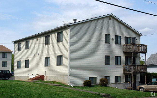
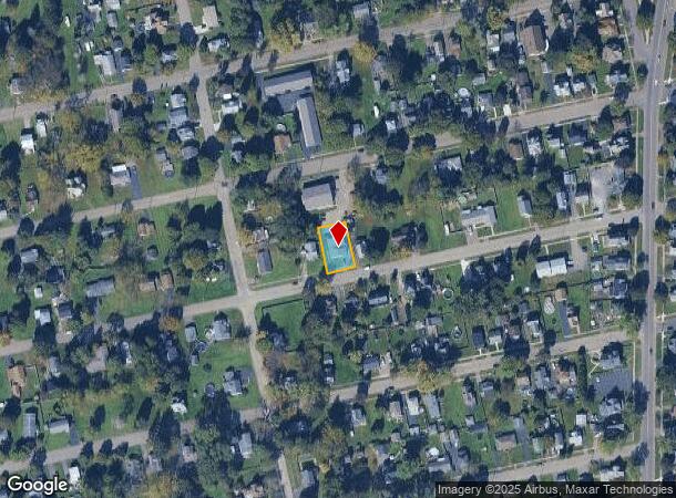
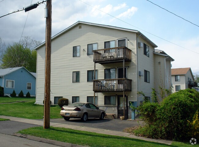
Property Record
228 W 11Th St, Elmira, NY 14903
NEARBY LISTINGS FOR SALE OR LEASE
-
-
View all Elmira listings for sale on LoopNet.com
Property Detail
228 W 11Th St
Elmira, NY
BLOCK 36 LOT 33 PT 34
073403-079-005-0005-031-001-0000
Chemung
Apartment
New York
2025
31.001
2024
0.21 AC
010600
Other Market Areas
5,820 SF
DEMOGRAPHICS near 228 W 11Th St
1 Mile
3 Mile
5 Mile
2024 Total Population
5,349
28,253
59,851
2029 Population
5,182
27,691
58,398
Pop Growth 2024-2029
(3.12%)
(1.99%)
(2.43%)
Average Age
41
41
42
2024 Total Households
2,148
12,151
25,727
HH Growth 2024-2029
(3.77%)
(2.09%)
(2.55%)
Median Household Inc
$55,430
$48,377
$57,179
Avg Household Size
2.10
2.10
2.20
2024 Avg HH Vehicles
2.00
1.00
2.00
Median Home Value
$95,065
$97,705
$119,466
Median Year Built
1948
1949
1951
Nearby Places
- Restaurants
- Banks
- Shops
- Fitness
- Groceries
PUBLIC TRANSPORTATION
AIRPORT
Elmira/Corning Regional
DRIVE
WALK
Distance
Elmira/Corning Regional
14 min
8.2 mi
Ithaca Tompkins International
DRIVE
WALK
Distance
Ithaca Tompkins International
53 min
36.8 mi
Nearby Properties
Address
Land Use
TOTAL SIZE
Lot Size
Zoning
Address
Land Use
TOTAL SIZE
Lot Size
Zoning
59 AC
UNZONED
Address
Land Use
TOTAL SIZE
Lot Size
Zoning
118,475 SF
0.71 AC
LAC2
Address
Land Use
TOTAL SIZE
Lot Size
Zoning
308,479 SF
28.20 AC
HA
Address
Land Use
TOTAL SIZE
Lot Size
Zoning
290,934 SF
13.50 AC
HED
Address
Land Use
TOTAL SIZE
Lot Size
Zoning
271,462 SF
7.50 AC
HS
Address
Land Use
TOTAL SIZE
Lot Size
Zoning
60,899 SF
207.30 AC
TH02
Address
Land Use
TOTAL SIZE
Lot Size
Zoning
213,707 SF
21.34 AC
TH08
Address
Land Use
TOTAL SIZE
Lot Size
Zoning
53,096 SF
10.32 AC
TH08
Address
Land Use
TOTAL SIZE
Lot Size
Zoning
Address
Land Use
TOTAL SIZE
Lot Size
Zoning
Address
Land Use
TOTAL SIZE
Lot Size
Zoning
25,388 SF
58.90 AC
RAA
Address
Land Use
TOTAL SIZE
Lot Size
Zoning
13,612 SF
15.30 AC
VH05
Address
Land Use
TOTAL SIZE
Lot Size
Zoning
18.61 AC
IB
Address
Land Use
TOTAL SIZE
Lot Size
Zoning
52,628 SF
2.40 AC
HED
Address
Land Use
TOTAL SIZE
Lot Size
Zoning
124,645 SF
12.09 AC
05 - COMME
Address
Land Use
TOTAL SIZE
Lot Size
Zoning
103,764 SF
31.98 AC
R2
Address
Land Use
TOTAL SIZE
Lot Size
Zoning
55,376 SF
32.80 AC
VH02
Address
Land Use
TOTAL SIZE
Lot Size
Zoning
7,203 SF
5.10 AC
06 - INDUS
Address
Land Use
TOTAL SIZE
Lot Size
Zoning
61,157 SF
1 AC
CBD
Address
Land Use
TOTAL SIZE
Lot Size
Zoning
99,188 SF
16.80 AC
R2
Address
Land Use
TOTAL SIZE
Lot Size
Zoning
51,280 SF
6.44 AC
TH08
Address
Land Use
TOTAL SIZE
Lot Size
Zoning
63,178 SF
3.32 AC
05 - COMME
Address
Land Use
TOTAL SIZE
Lot Size
Zoning
136,977 SF
2.55 AC
HED
Address
Land Use
TOTAL SIZE
Lot Size
Zoning
194,626 SF
10.20 AC
RAA
Address
Land Use
TOTAL SIZE
Lot Size
Zoning
5,562 SF
22.64 AC
RD
Address
Land Use
TOTAL SIZE
Lot Size
Zoning
248,126 SF
20.60 AC
VH05
Address
Land Use
TOTAL SIZE
Lot Size
Zoning
14.10 AC
M
Address
Land Use
TOTAL SIZE
Lot Size
Zoning
420,041 SF
46.55 AC
VH08
Address
Land Use
TOTAL SIZE
Lot Size
Zoning
157,418 SF
0.72 AC
CBD
Address
Land Use
TOTAL SIZE
Lot Size
Zoning
82,385 SF
18.38 AC
BE
The World's #1 Commercial Real Estate Marketplace
Connect with us
© 2025 CoStar Group
The information above has been obtained from sources believed reliable. While we do not doubt its accuracy we have not verified it and make no guarantee, warranty or representation about it. It is your responsibility to independently confirm its accuracy and completeness. Any projections, opinions, assumptions, or estimates used are for example only and do not represent the current or future performance of the property. The value of this transaction to you depends on tax and other factors which should be evaluated by your tax, financial, and legal advisors. You and your advisors should conduct a careful, independent investigation of the property to determine to your satisfaction the suitability of the property for your needs.