Property Record
22801 Emery Rd, Cleveland, OH 44128

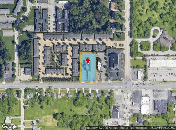
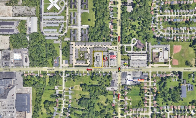
This Property Is For Sale
NEARBY LISTINGS FOR SALE OR LEASE
Property Detail
22801 Emery Rd
Cleveland-Elyria, OH
Est
761-22-033
87 EST 300D
Restaurantdrivein
Cuyahoga
X
Ohio
39035C0217E
87
2024
1.09 AC
2024
Southeast
198300
Cleveland
6,572 SF
DEMOGRAPHICS near 22801 Emery Rd
1 Mile
3 Mile
5 Mile
2024 Total Population
7,944
78,083
213,006
2029 Population
7,778
76,266
208,167
Pop Growth 2024-2029
(2.09%)
(2.33%)
(2.27%)
Average Age
40
42
42
2024 Total Households
3,624
34,676
91,148
HH Growth 2024-2029
(2.43%)
(2.54%)
(2.43%)
Median Household Inc
$38,988
$54,345
$56,006
Avg Household Size
2.10
2.20
2.20
2024 Avg HH Vehicles
1.00
1.00
2.00
Median Home Value
$124,671
$120,630
$144,455
Median Year Built
1962
1956
1954
Nearby Places
Map Layers
Map Styles
 Street
 Aerial
- Restaurants
- Banks
- Shops
- Fitness
- Groceries
PUBLIC TRANSPORTATION
COMMUTER RAIL
Rockside (National Park Scenic Railway - Cuyahoga Valley Scenic Railroad)
DRIVE
WALK
Distance
Rockside (National Park Scenic Railway - Cuyahoga Valley Scenic Railroad)
16 min
8.9 mi
AIRPORT
Cleveland-Hopkins International
DRIVE
WALK
Distance
Cleveland-Hopkins International
30 min
19.4 mi
Freight Ports
Port of Toledo
DRIVE
WALK
Distance
Port of Toledo
144 min
120.3 mi
Nearby Properties
Address
Land Use
TOTAL SIZE
Lot Size
Zoning
Address
Land Use
TOTAL SIZE
Lot Size
Zoning
975,742 SF
42.03 AC
U-10
Address
Land Use
TOTAL SIZE
Lot Size
Zoning
418,553 SF
40.99 AC
Address
Land Use
TOTAL SIZE
Lot Size
Zoning
737,998 SF
53.07 AC
U-10
Address
Land Use
TOTAL SIZE
Lot Size
Zoning
475,904 SF
8.04 AC
U-7A
Address
Land Use
TOTAL SIZE
Lot Size
Zoning
68.97 AC
C-1
Address
Land Use
TOTAL SIZE
Lot Size
Zoning
682,144 SF
99.58 AC
C-2
Address
Land Use
TOTAL SIZE
Lot Size
Zoning
341,556 SF
17.70 AC
U-4
Address
Land Use
TOTAL SIZE
Lot Size
Zoning
729,492 SF
17.67 AC
Address
Land Use
TOTAL SIZE
Lot Size
Zoning
323,733 SF
106.35 AC
MRC2
Address
Land Use
TOTAL SIZE
Lot Size
Zoning
233,767 SF
36.30 AC
U-1A1
Address
Land Use
TOTAL SIZE
Lot Size
Zoning
257,564 SF
2.70 AC
U-4A
Address
Land Use
TOTAL SIZE
Lot Size
Zoning
333,582 SF
3.67 AC
U-1A1
Address
Land Use
TOTAL SIZE
Lot Size
Zoning
360,712 SF
55.30 AC
INS
Address
Land Use
TOTAL SIZE
Lot Size
Zoning
485,482 SF
9.60 AC
U-8A
Address
Land Use
TOTAL SIZE
Lot Size
Zoning
144,978 SF
31.14 AC
R-3
Address
Land Use
TOTAL SIZE
Lot Size
Zoning
78,838 SF
4.90 AC
U-7A
Address
Land Use
TOTAL SIZE
Lot Size
Zoning
289,009 SF
25.27 AC
I/O
Address
Land Use
TOTAL SIZE
Lot Size
Zoning
232,078 SF
24.89 AC
U-7
Address
Land Use
TOTAL SIZE
Lot Size
Zoning
357,252 SF
10.80 AC
U-8A
Address
Land Use
TOTAL SIZE
Lot Size
Zoning
92,058 SF
31.37 AC
INS
Address
Land Use
TOTAL SIZE
Lot Size
Zoning
143,512 SF
16 AC
Address
Land Use
TOTAL SIZE
Lot Size
Zoning
204,701 SF
10.12 AC
Address
Land Use
TOTAL SIZE
Lot Size
Zoning
4,414 SF
112.92 AC
U-10
Address
Land Use
TOTAL SIZE
Lot Size
Zoning
99,919 SF
17.91 AC
U-1A1
Address
Land Use
TOTAL SIZE
Lot Size
Zoning
60,001 SF
8.29 AC
Address
Land Use
TOTAL SIZE
Lot Size
Zoning
18,898 SF
3.57 AC
U-3
Address
Land Use
TOTAL SIZE
Lot Size
Zoning
18.38 AC
R2
Address
Land Use
TOTAL SIZE
Lot Size
Zoning
114,885 SF
1.21 AC
Address
Land Use
TOTAL SIZE
Lot Size
Zoning
196,429 SF
10.31 AC
U-7
Address
Land Use
TOTAL SIZE
Lot Size
Zoning
120,722 SF
20.55 AC
I/O
The World's #1 Commercial Real Estate Marketplace
Connect with us
© 2025 CoStar Group
The information above has been obtained from sources believed reliable. While we do not doubt its accuracy we have not verified it and make no guarantee, warranty or representation about it. It is your responsibility to independently confirm its accuracy and completeness. Any projections, opinions, assumptions, or estimates used are for example only and do not represent the current or future performance of the property. The value of this transaction to you depends on tax and other factors which should be evaluated by your tax, financial, and legal advisors. You and your advisors should conduct a careful, independent investigation of the property to determine to your satisfaction the suitability of the property for your needs.