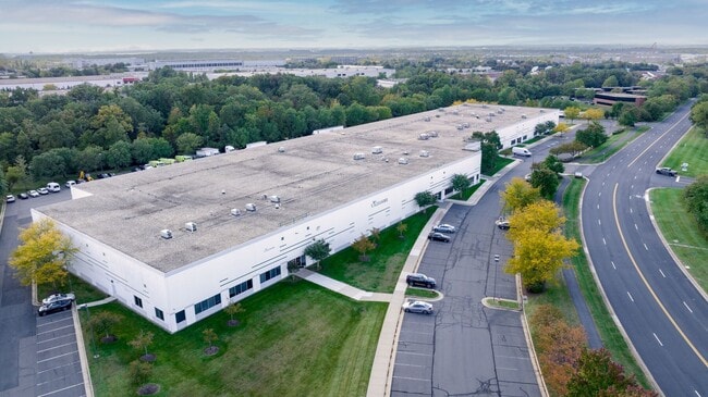
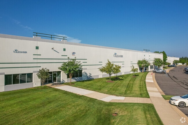
Property Record
22815 Glenn Dr, Sterling, VA 20164

Current Lease Availabilities
NEARBY LISTINGS FOR SALE OR LEASE
Property Detail
22815 Glenn Dr
Washington-Arlington-Alexandria, DC-VA-MD-WV
Industrial Park
033-17-9880
INDUSTRIAL PARK-STERLING SEC.5 LOT 49A 200702120011565 PC E-3211-1 BLA
Warehouse
Loudoun
X
Virginia
51107C0385E
49a
2025
16.09 AC
2025
Rt 28/Dulles North
611702
Washington, DC
126,841 SF
DEMOGRAPHICS near 22815 Glenn Dr
1 Mile
3 Mile
5 Mile
2024 Total Population
10,471
95,611
259,721
2029 Population
11,146
97,805
268,607
Pop Growth 2024-2029
+ 6.45%
+ 2.29%
+ 3.42%
Average Age
37
36
38
2024 Total Households
3,243
32,611
95,016
HH Growth 2024-2029
+ 6.60%
+ 2.33%
+ 3.40%
Median Household Inc
$118,465
$120,639
$132,183
Avg Household Size
3.10
2.80
2.70
2024 Avg HH Vehicles
2.00
2.00
2.00
Median Home Value
$432,912
$494,134
$623,389
Median Year Built
1982
1989
1992
Nearby Places
Map Layers
Map Styles
 Street
 Aerial
- Restaurants
- Banks
- Shops
- Fitness
- Groceries
PUBLIC TRANSPORTATION
AIRPORT
Washington Dulles International
DRIVE
WALK
Distance
Washington Dulles International
13 min
5.2 mi
Ronald Reagan Washington Ntl
DRIVE
WALK
Distance
Ronald Reagan Washington Ntl
46 min
30.4 mi
Freight Ports
Port of Baltimore
DRIVE
WALK
Distance
Port of Baltimore
86 min
62.5 mi
Nearby Properties
Address
Land Use
TOTAL SIZE
Lot Size
Zoning
Address
Land Use
TOTAL SIZE
Lot Size
Zoning
2,700,000 SF
7.51 AC
PDGI
Address
Land Use
TOTAL SIZE
Lot Size
Zoning
521,784 SF
PDOP
Address
Land Use
TOTAL SIZE
Lot Size
Zoning
462,210 SF
PDOP
Address
Land Use
TOTAL SIZE
Lot Size
Zoning
650,346 SF
PDMUB
Address
Land Use
TOTAL SIZE
Lot Size
Zoning
800,702 SF
111.70 AC
PDIP
Address
Land Use
TOTAL SIZE
Lot Size
Zoning
789,350 SF
31.73 AC
PDOP
Address
Land Use
TOTAL SIZE
Lot Size
Zoning
234,124 SF
23.84 AC
PDOP
Address
Land Use
TOTAL SIZE
Lot Size
Zoning
672,272 SF
44.53 AC
PDIP
Address
Land Use
TOTAL SIZE
Lot Size
Zoning
427,320 SF
16.33 AC
PDIP
Address
Land Use
TOTAL SIZE
Lot Size
Zoning
364,600 SF
PDOP
Address
Land Use
TOTAL SIZE
Lot Size
Zoning
493,504 SF
15.73 AC
PDOP
Address
Land Use
TOTAL SIZE
Lot Size
Zoning
308,630 SF
14.44 AC
PDIP
Address
Land Use
TOTAL SIZE
Lot Size
Zoning
147,260 SF
33.04 AC
PDIP
Address
Land Use
TOTAL SIZE
Lot Size
Zoning
565,680 SF
18.44 AC
PDIP
Address
Land Use
TOTAL SIZE
Lot Size
Zoning
228,606 SF
PDOP
Address
Land Use
TOTAL SIZE
Lot Size
Zoning
180,355 SF
12.89 AC
PDIP
Address
Land Use
TOTAL SIZE
Lot Size
Zoning
764,166 SF
73.90 AC
PDIP
Address
Land Use
TOTAL SIZE
Lot Size
Zoning
226,456 SF
17.09 AC
PDIP
Address
Land Use
TOTAL SIZE
Lot Size
Zoning
154,125 SF
9.68 AC
PDIP
Address
Land Use
TOTAL SIZE
Lot Size
Zoning
364,650 SF
PDOP
Address
Land Use
TOTAL SIZE
Lot Size
Zoning
169,092 SF
PDMUB
Address
Land Use
TOTAL SIZE
Lot Size
Zoning
253,352 SF
PDOP
Address
Land Use
TOTAL SIZE
Lot Size
Zoning
685,682 SF
53.96 AC
PDIP
Address
Land Use
TOTAL SIZE
Lot Size
Zoning
252,473 SF
9.03 AC
PDIP
Address
Land Use
TOTAL SIZE
Lot Size
Zoning
405,058 SF
19.88 AC
IP
Address
Land Use
TOTAL SIZE
Lot Size
Zoning
120,240 SF
12.15 AC
PDIP
Address
Land Use
TOTAL SIZE
Lot Size
Zoning
585,593 SF
15.38 AC
PDOP
Address
Land Use
TOTAL SIZE
Lot Size
Zoning
180,039 SF
15.98 AC
PDOP
Address
Land Use
TOTAL SIZE
Lot Size
Zoning
259,194 SF
10.18 AC
PDIP
Address
Land Use
TOTAL SIZE
Lot Size
Zoning
128,500 SF
9.95 AC
PDIP
The World's #1 Commercial Real Estate Marketplace
Connect with us
© 2026 CoStar Group
The information above has been obtained from sources believed reliable. While we do not doubt its accuracy we have not verified it and make no guarantee, warranty or representation about it. It is your responsibility to independently confirm its accuracy and completeness. Any projections, opinions, assumptions, or estimates used are for example only and do not represent the current or future performance of the property. The value of this transaction to you depends on tax and other factors which should be evaluated by your tax, financial, and legal advisors. You and your advisors should conduct a careful, independent investigation of the property to determine to your satisfaction the suitability of the property for your needs.