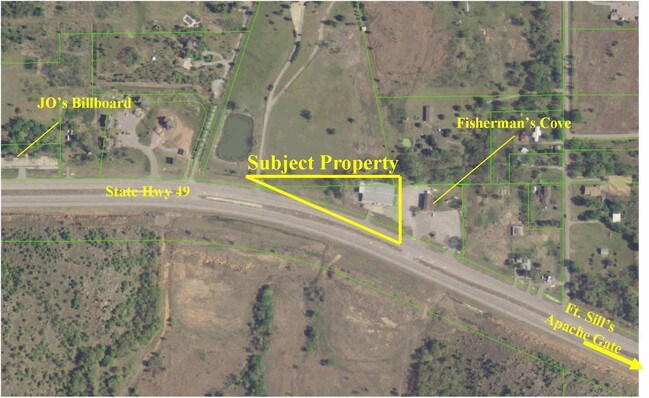
Property Record
22821 State Highway 49, Lawton, OK 73507

NEARBY LISTINGS FOR SALE OR LEASE
-
-
View all Lawton listings for sale on LoopNet.com
Property Detail
22821 State Highway 49
0042503
Farm 3N-12W
Warehouse
23-3N-12W BEG AT A PT 769.8' (N89*52'18W) OF NE/C NE/4 SEC 23 THN (N89*52'18W) A DIST 667.21', THN SOUTHEASTERLY ON A CUR TO
X
Comanche
40031C0275E
Oklahoma
2024
1.38 AC
2025
Oklahoma West Area
002202
Other Market Areas
12,690 SF
Lawton, OK
DEMOGRAPHICS near 22821 State Highway 49
1 Mile
3 Mile
5 Mile
2024 Total Population
738
1,965
5,758
2029 Population
750
1,988
5,797
Pop Growth 2024-2029
+ 1.63%
+ 1.17%
+ 0.68%
Average Age
44
40
32
2024 Total Households
275
679
1,588
HH Growth 2024-2029
+ 1.45%
+ 1.03%
0.00%
Median Household Inc
$103,552
$100,658
$75,950
Avg Household Size
2.70
2.70
2.90
2024 Avg HH Vehicles
3.00
3.00
2.00
Median Home Value
$252,258
$251,552
$252,031
Median Year Built
1991
1991
1984
Nearby Places
Map Layers
Map Styles
 Street
 Aerial
- Restaurants
- Banks
- Shops
- Fitness
- Groceries
PUBLIC TRANSPORTATION
AIRPORT
Lawton-Fort Sill Regional
DRIVE
WALK
Distance
Lawton-Fort Sill Regional
24 min
14.5 mi
Freight Ports
Tulsa Port Of Catoosa
DRIVE
WALK
Distance
Tulsa Port Of Catoosa
218 min
203.8 mi
Nearby Properties
Address
Land Use
TOTAL SIZE
Lot Size
Zoning
Address
Land Use
TOTAL SIZE
Lot Size
Zoning
22,272 SF
17.25 AC
Address
Land Use
TOTAL SIZE
Lot Size
Zoning
4,298 SF
1.92 AC
Address
Land Use
TOTAL SIZE
Lot Size
Zoning
3,672 SF
1.97 AC
Address
Land Use
TOTAL SIZE
Lot Size
Zoning
4,112 SF
2.17 AC
Address
Land Use
TOTAL SIZE
Lot Size
Zoning
3,000 SF
1.68 AC
Address
Land Use
TOTAL SIZE
Lot Size
Zoning
3,618 SF
0.98 AC
Address
Land Use
TOTAL SIZE
Lot Size
Zoning
4,260 SF
1.19 AC
Address
Land Use
TOTAL SIZE
Lot Size
Zoning
10,620 SF
1.46 AC
Address
Land Use
TOTAL SIZE
Lot Size
Zoning
8,250 SF
2.25 AC
Address
Land Use
TOTAL SIZE
Lot Size
Zoning
15.23 AC
Address
Land Use
TOTAL SIZE
Lot Size
Zoning
3,409 SF
2 AC
Address
Land Use
TOTAL SIZE
Lot Size
Zoning
3,444 SF
0.83 AC
Address
Land Use
TOTAL SIZE
Lot Size
Zoning
7,500 SF
1.39 AC
Address
Land Use
TOTAL SIZE
Lot Size
Zoning
2,340 SF
1.73 AC
Address
Land Use
TOTAL SIZE
Lot Size
Zoning
768 SF
3.40 AC
Address
Land Use
TOTAL SIZE
Lot Size
Zoning
1,848 SF
5 AC
Address
Land Use
TOTAL SIZE
Lot Size
Zoning
1,500 SF
3.92 AC
Address
Land Use
TOTAL SIZE
Lot Size
Zoning
741 SF
1.15 AC
Address
Land Use
TOTAL SIZE
Lot Size
Zoning
1,350 SF
6.24 AC
Address
Land Use
TOTAL SIZE
Lot Size
Zoning
2,254 SF
1.24 AC
Address
Land Use
TOTAL SIZE
Lot Size
Zoning
100 SF
0.23 AC
Address
Land Use
TOTAL SIZE
Lot Size
Zoning
2,000 SF
0.71 AC
Address
Land Use
TOTAL SIZE
Lot Size
Zoning
Address
Land Use
TOTAL SIZE
Lot Size
Zoning
420 SF
2.85 AC
Address
Land Use
TOTAL SIZE
Lot Size
Zoning
3,760 SF
0.55 AC
Address
Land Use
TOTAL SIZE
Lot Size
Zoning
1,300 SF
1.86 AC
Address
Land Use
TOTAL SIZE
Lot Size
Zoning
3.70 AC
Address
Land Use
TOTAL SIZE
Lot Size
Zoning
3,601 SF
0.50 AC
Address
Land Use
TOTAL SIZE
Lot Size
Zoning
2,417 SF
160 AC
NP
The World's #1 Commercial Real Estate Marketplace
Connect with us
© 2026 CoStar Group
The information above has been obtained from sources believed reliable. While we do not doubt its accuracy we have not verified it and make no guarantee, warranty or representation about it. It is your responsibility to independently confirm its accuracy and completeness. Any projections, opinions, assumptions, or estimates used are for example only and do not represent the current or future performance of the property. The value of this transaction to you depends on tax and other factors which should be evaluated by your tax, financial, and legal advisors. You and your advisors should conduct a careful, independent investigation of the property to determine to your satisfaction the suitability of the property for your needs.