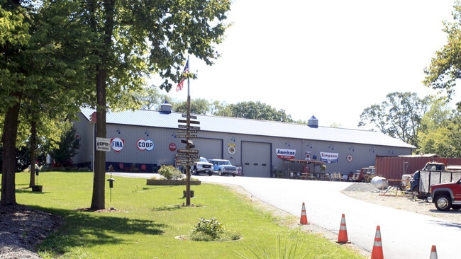
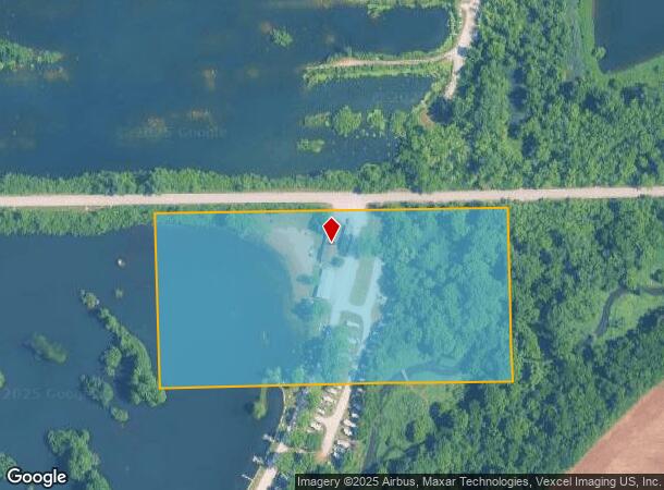
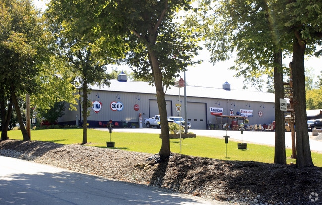
Property Record
22823 W 143Rd St, Plainfield, IL 60544
NEARBY LISTINGS FOR SALE OR LEASE
Property Detail
22823 W 143Rd St
06-03-11-100-007
THE N 500 FT OF THE FOLLOWING DESCRIBED PARCEL: THAT PRT OF THE NW1/4 OF SEC 11, T36N-R9E, SW OF THE OLD IBL, DAF: BEG AT A P
Commercialnec
Will
AE
Illinois
17197C0135G
10.90 AC
2024
I-88 West
2024
Chicago
880411
Chicago-Naperville-Elgin, IL-IN-WI
DEMOGRAPHICS near 22823 W 143Rd St
1 Mile
3 Mile
5 Mile
2024 Total Population
3,860
61,962
155,979
2029 Population
3,828
61,846
156,010
Pop Growth 2024-2029
(0.83%)
(0.19%)
+ 0.02%
Average Age
36
39
39
2024 Total Households
1,222
21,078
50,980
HH Growth 2024-2029
(0.82%)
(0.15%)
+ 0.02%
Median Household Inc
$110,745
$100,747
$108,729
Avg Household Size
3.10
2.90
3.00
2024 Avg HH Vehicles
2.00
2.00
2.00
Median Home Value
$267,489
$272,970
$278,978
Median Year Built
1994
1999
1998
Nearby Places
Map Layers
Map Styles
 Street
 Aerial
- Restaurants
- Banks
- Shops
- Fitness
- Groceries
PUBLIC TRANSPORTATION
COMMUTER RAIL
Lockport Station (Heritage Corridor Line - Northeast Illinois Regional Commuter Railroad (Metra))
DRIVE
WALK
Distance
Lockport Station (Heritage Corridor Line - Northeast Illinois Regional Commuter Railroad (Metra))
19 min
8.8 mi
Romeoville (Heritage Corridor - Metra)
DRIVE
WALK
Distance
Romeoville (Heritage Corridor - Metra)
19 min
9.4 mi
AIRPORT
Chicago Midway International
DRIVE
WALK
Distance
Chicago Midway International
36 min
26.8 mi
Chicago O'Hare International
DRIVE
WALK
Distance
Chicago O'Hare International
54 min
38.2 mi
Freight Ports
Port Milwaukee
DRIVE
WALK
Distance
Port Milwaukee
135 min
109.9 mi
Nearby Properties
Address
Land Use
TOTAL SIZE
Lot Size
Zoning
Address
Land Use
TOTAL SIZE
Lot Size
Zoning
952,135 SF
21.86 AC
Address
Land Use
TOTAL SIZE
Lot Size
Zoning
20.75 AC
Address
Land Use
TOTAL SIZE
Lot Size
Zoning
14.67 AC
Address
Land Use
TOTAL SIZE
Lot Size
Zoning
12.47 AC
Address
Land Use
TOTAL SIZE
Lot Size
Zoning
21.76 AC
Address
Land Use
TOTAL SIZE
Lot Size
Zoning
800,000 SF
43.13 AC
Address
Land Use
TOTAL SIZE
Lot Size
Zoning
715,638 SF
35.12 AC
Address
Land Use
TOTAL SIZE
Lot Size
Zoning
965,899 SF
22.17 AC
Address
Land Use
TOTAL SIZE
Lot Size
Zoning
33.74 AC
Address
Land Use
TOTAL SIZE
Lot Size
Zoning
14.59 AC
Address
Land Use
TOTAL SIZE
Lot Size
Zoning
10.47 AC
Address
Land Use
TOTAL SIZE
Lot Size
Zoning
21.96 AC
Address
Land Use
TOTAL SIZE
Lot Size
Zoning
25.13 AC
Address
Land Use
TOTAL SIZE
Lot Size
Zoning
7.72 AC
Address
Land Use
TOTAL SIZE
Lot Size
Zoning
33.04 AC
Address
Land Use
TOTAL SIZE
Lot Size
Zoning
355,535 SF
23.47 AC
Address
Land Use
TOTAL SIZE
Lot Size
Zoning
30.80 AC
Address
Land Use
TOTAL SIZE
Lot Size
Zoning
23.79 AC
Address
Land Use
TOTAL SIZE
Lot Size
Zoning
24.91 AC
Address
Land Use
TOTAL SIZE
Lot Size
Zoning
20.22 AC
Address
Land Use
TOTAL SIZE
Lot Size
Zoning
29.03 AC
Address
Land Use
TOTAL SIZE
Lot Size
Zoning
232,964 SF
28.66 AC
Address
Land Use
TOTAL SIZE
Lot Size
Zoning
36.79 AC
Address
Land Use
TOTAL SIZE
Lot Size
Zoning
260,860 SF
13.80 AC
Address
Land Use
TOTAL SIZE
Lot Size
Zoning
189,335 SF
10.67 AC
Address
Land Use
TOTAL SIZE
Lot Size
Zoning
809,512 SF
25.04 AC
Address
Land Use
TOTAL SIZE
Lot Size
Zoning
643,468 SF
14.77 AC
Address
Land Use
TOTAL SIZE
Lot Size
Zoning
577,610 SF
13.05 AC
Address
Land Use
TOTAL SIZE
Lot Size
Zoning
521,457 SF
11.97 AC
Address
Land Use
TOTAL SIZE
Lot Size
Zoning
42.16 AC
The World's #1 Commercial Real Estate Marketplace
Connect with us
© 2025 CoStar Group
The information above has been obtained from sources believed reliable. While we do not doubt its accuracy we have not verified it and make no guarantee, warranty or representation about it. It is your responsibility to independently confirm its accuracy and completeness. Any projections, opinions, assumptions, or estimates used are for example only and do not represent the current or future performance of the property. The value of this transaction to you depends on tax and other factors which should be evaluated by your tax, financial, and legal advisors. You and your advisors should conduct a careful, independent investigation of the property to determine to your satisfaction the suitability of the property for your needs.