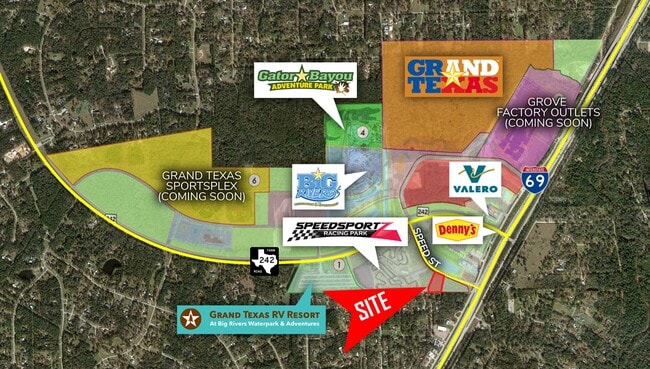
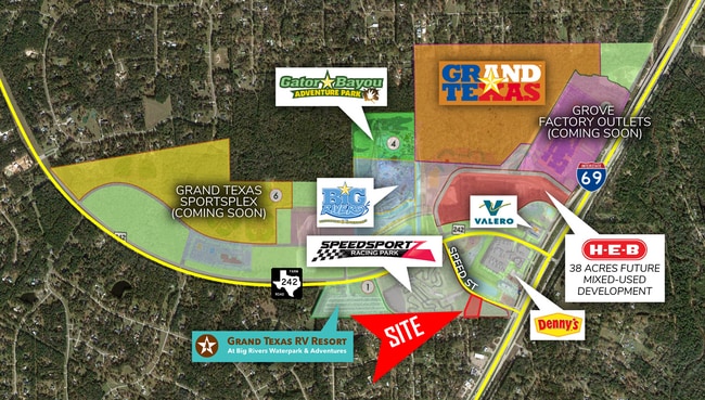
Property Record
22830 State Highway 242, New Caney, TX 77357

NEARBY LISTINGS FOR SALE OR LEASE
Property Detail
22830 State Highway 242
Houston-The Woodlands-Sugar Land, TX
Palmetto Apex Real Estate Fund Developme
7704-00-00301
PALMETTO APEX REAL ESTATE FUND DEVELOPMENT, RES C-1, ACRES 1.4813
Commercialnec
Montgomery
X
Texas
48339C0600G
1.48 AC
2024
Outlying Montgomery Cnty
2025
Houston
692702
DEMOGRAPHICS near 22830 State Highway 242
1 Mile
3 Mile
5 Mile
2024 Total Population
1,788
20,847
48,669
2029 Population
2,232
26,206
60,804
Pop Growth 2024-2029
+ 24.83%
+ 25.71%
+ 24.93%
Average Age
40
37
36
2024 Total Households
632
6,903
15,834
HH Growth 2024-2029
+ 25.16%
+ 25.81%
+ 25.07%
Median Household Inc
$80,078
$86,758
$72,975
Avg Household Size
2.80
3.00
3.00
2024 Avg HH Vehicles
3.00
2.00
2.00
Median Home Value
$252,608
$258,366
$222,704
Median Year Built
2000
2006
2002
Nearby Places
Map Layers
Map Styles
 Street
 Aerial
- Restaurants
- Banks
- Shops
- Fitness
- Groceries
PUBLIC TRANSPORTATION
AIRPORT
George Bush Intcntl/Houston
DRIVE
WALK
Distance
George Bush Intcntl/Houston
27 min
22.3 mi
Freight Ports
Port of Houston
DRIVE
WALK
Distance
Port of Houston
48 min
37.6 mi
SALE & LEASE HISTORY
LISTING DATE
SALE/LEASE

Jul 14, 2020
For Sale
Nearby Properties
Address
Land Use
TOTAL SIZE
Lot Size
Zoning
Address
Land Use
TOTAL SIZE
Lot Size
Zoning
131,364 SF
4.63 AC
5
Address
Land Use
TOTAL SIZE
Lot Size
Zoning
110,013 SF
13.91 AC
5
Address
Land Use
TOTAL SIZE
Lot Size
Zoning
102,184 SF
20.35 AC
Address
Land Use
TOTAL SIZE
Lot Size
Zoning
54,372 SF
6.26 AC
Address
Land Use
TOTAL SIZE
Lot Size
Zoning
68,756 SF
2.10 AC
Address
Land Use
TOTAL SIZE
Lot Size
Zoning
15,368 SF
12.24 AC
Address
Land Use
TOTAL SIZE
Lot Size
Zoning
20,200 SF
26.46 AC
Address
Land Use
TOTAL SIZE
Lot Size
Zoning
15,000 SF
1.57 AC
Address
Land Use
TOTAL SIZE
Lot Size
Zoning
55,676 SF
5.40 AC
5
Address
Land Use
TOTAL SIZE
Lot Size
Zoning
3,597 SF
17.87 AC
Address
Land Use
TOTAL SIZE
Lot Size
Zoning
48,405 SF
30.58 AC
5
Address
Land Use
TOTAL SIZE
Lot Size
Zoning
15,638 SF
17.29 AC
5
Address
Land Use
TOTAL SIZE
Lot Size
Zoning
62,486 SF
3.53 AC
5
Address
Land Use
TOTAL SIZE
Lot Size
Zoning
18.30 AC
Address
Land Use
TOTAL SIZE
Lot Size
Zoning
77,118 SF
5.64 AC
5
Address
Land Use
TOTAL SIZE
Lot Size
Zoning
3,880 SF
13.32 AC
5
Address
Land Use
TOTAL SIZE
Lot Size
Zoning
13,420 SF
7.82 AC
5
Address
Land Use
TOTAL SIZE
Lot Size
Zoning
5,900 SF
2.97 AC
Address
Land Use
TOTAL SIZE
Lot Size
Zoning
70,376 SF
11.21 AC
5
Address
Land Use
TOTAL SIZE
Lot Size
Zoning
8,432 SF
2.87 AC
Address
Land Use
TOTAL SIZE
Lot Size
Zoning
48,400 SF
4.14 AC
Address
Land Use
TOTAL SIZE
Lot Size
Zoning
19,587 SF
3.50 AC
Address
Land Use
TOTAL SIZE
Lot Size
Zoning
11,064 SF
1.20 AC
Address
Land Use
TOTAL SIZE
Lot Size
Zoning
50,960 SF
6.06 AC
Address
Land Use
TOTAL SIZE
Lot Size
Zoning
48,198 SF
4.68 AC
5
The World's #1 Commercial Real Estate Marketplace
Connect with us
© 2025 CoStar Group
The information above has been obtained from sources believed reliable. While we do not doubt its accuracy we have not verified it and make no guarantee, warranty or representation about it. It is your responsibility to independently confirm its accuracy and completeness. Any projections, opinions, assumptions, or estimates used are for example only and do not represent the current or future performance of the property. The value of this transaction to you depends on tax and other factors which should be evaluated by your tax, financial, and legal advisors. You and your advisors should conduct a careful, independent investigation of the property to determine to your satisfaction the suitability of the property for your needs.