Property Record
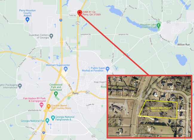
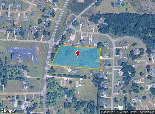
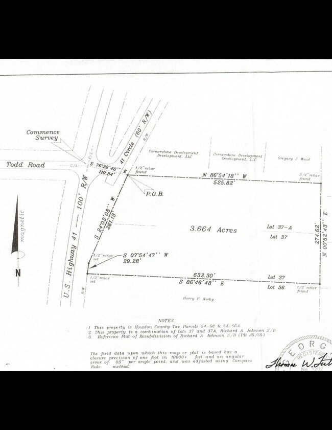
2284 Us Highway 41 S, Perry, GA 31069
NEARBY LISTINGS FOR SALE OR LEASE
Property Detail
2284 Us Highway 41 S
000540056000
3.664 ACRES LL 74 10TH LD
Residentialacreage
Houston
X
Georgia
13225C0150C
3.66 AC
2024
Perry/Warner Robins
2024
Other Market Areas
021206
Warner Robins, GA
DEMOGRAPHICS near 2284 Us Highway 41 S
1 Mile
3 Mile
5 Mile
2024 Total Population
1,566
14,676
52,961
2029 Population
1,745
16,318
58,119
Pop Growth 2024-2029
+ 11.43%
+ 11.19%
+ 9.74%
Average Age
36
39
37
2024 Total Households
572
5,603
19,291
HH Growth 2024-2029
+ 11.36%
+ 11.03%
+ 9.56%
Median Household Inc
$66,435
$85,077
$87,140
Avg Household Size
2.70
2.60
2.70
2024 Avg HH Vehicles
2.00
2.00
2.00
Median Home Value
$175,496
$211,869
$197,694
Median Year Built
2004
2002
2002
Nearby Places
Map Layers
Map Styles
 Street
 Aerial
- Restaurants
- Banks
- Shops
- Fitness
- Groceries
SALE & LEASE HISTORY
LISTING DATE
SALE/LEASE

Aug 16, 2022
For Sale
Nearby Properties
Address
Land Use
TOTAL SIZE
Lot Size
Zoning
Address
Land Use
TOTAL SIZE
Lot Size
Zoning
158,407 SF
218.84 AC
M2
Address
Land Use
TOTAL SIZE
Lot Size
Zoning
262,500 SF
20 AC
GU
Address
Land Use
TOTAL SIZE
Lot Size
Zoning
0.44 AC
Address
Land Use
TOTAL SIZE
Lot Size
Zoning
158,300 SF
43.81 AC
GU
Address
Land Use
TOTAL SIZE
Lot Size
Zoning
158,300 SF
30 AC
GU
Address
Land Use
TOTAL SIZE
Lot Size
Zoning
120,000 SF
20 AC
M1
Address
Land Use
TOTAL SIZE
Lot Size
Zoning
49,947 SF
4.03 AC
C2
Address
Land Use
TOTAL SIZE
Lot Size
Zoning
439.32 AC
M2
Address
Land Use
TOTAL SIZE
Lot Size
Zoning
439.32 AC
M2
Address
Land Use
TOTAL SIZE
Lot Size
Zoning
5,736 SF
16.65 AC
RM-2
Address
Land Use
TOTAL SIZE
Lot Size
Zoning
91,249 SF
15.85 AC
GU
Address
Land Use
TOTAL SIZE
Lot Size
Zoning
25,002 SF
15.17 AC
RM-2
Address
Land Use
TOTAL SIZE
Lot Size
Zoning
151,525 SF
17.55 AC
C2
Address
Land Use
TOTAL SIZE
Lot Size
Zoning
106,055 SF
22.72 AC
GU
Address
Land Use
TOTAL SIZE
Lot Size
Zoning
46,200 SF
12.29 AC
C2
Address
Land Use
TOTAL SIZE
Lot Size
Zoning
31,248 SF
10.30 AC
RM-2
Address
Land Use
TOTAL SIZE
Lot Size
Zoning
54,262 SF
38.29 AC
M1
Address
Land Use
TOTAL SIZE
Lot Size
Zoning
4,820 SF
14.59 AC
RM-2
Address
Land Use
TOTAL SIZE
Lot Size
Zoning
12,000 SF
7.27 AC
RM-2
Address
Land Use
TOTAL SIZE
Lot Size
Zoning
4,800 SF
101.24 AC
RAG
Address
Land Use
TOTAL SIZE
Lot Size
Zoning
218.84 AC
M2
Address
Land Use
TOTAL SIZE
Lot Size
Zoning
4,820 SF
14.95 AC
RM-2
Address
Land Use
TOTAL SIZE
Lot Size
Zoning
6,948 SF
10 AC
C2
Address
Land Use
TOTAL SIZE
Lot Size
Zoning
13,888 SF
2.90 AC
C1
Address
Land Use
TOTAL SIZE
Lot Size
Zoning
30,451 SF
10.19 AC
C2
Address
Land Use
TOTAL SIZE
Lot Size
Zoning
13,792 SF
10 AC
C1
Address
Land Use
TOTAL SIZE
Lot Size
Zoning
14,161 SF
3.78 AC
C1
Address
Land Use
TOTAL SIZE
Lot Size
Zoning
120,000 SF
20 AC
M1
Address
Land Use
TOTAL SIZE
Lot Size
Zoning
3,200 SF
9.61 AC
RM-2
Address
Land Use
TOTAL SIZE
Lot Size
Zoning
22,832 SF
3.01 AC
C1
The World's #1 Commercial Real Estate Marketplace
Connect with us
© 2025 CoStar Group
The information above has been obtained from sources believed reliable. While we do not doubt its accuracy we have not verified it and make no guarantee, warranty or representation about it. It is your responsibility to independently confirm its accuracy and completeness. Any projections, opinions, assumptions, or estimates used are for example only and do not represent the current or future performance of the property. The value of this transaction to you depends on tax and other factors which should be evaluated by your tax, financial, and legal advisors. You and your advisors should conduct a careful, independent investigation of the property to determine to your satisfaction the suitability of the property for your needs.