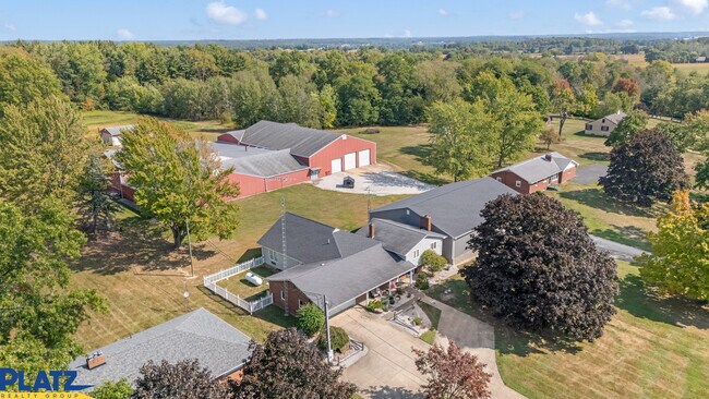
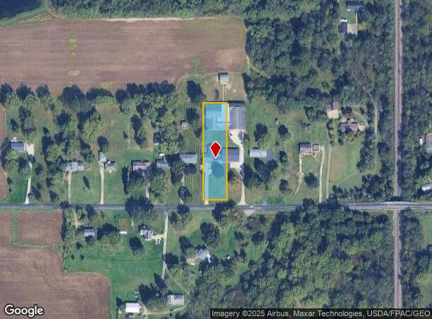
Property Record
22840 Buck Rd, Alliance, OH 44601

NEARBY LISTINGS FOR SALE OR LEASE
-
-
View all Alliance listings for sale on LoopNet.com
Property Detail
22840 Buck Rd
3100636000
Benner Allotment
Publicstorage
9 BENNER 100 L/E TO DALE E & PATRICIA A TUEL 12/27/2013 TOD DES TO CHARLES E TUEL & BETHANNE M TUEL TRUSTEES 4/26/23
X
Columbiana
39029C0150E
Ohio
2024
0.93 AC
2024
Ohio North Area
950900
Other Market Areas
2,257 SF
Salem, OH
DEMOGRAPHICS near 22840 Buck Rd
1 Mile
3 Mile
5 Mile
2024 Total Population
442
9,424
36,350
2029 Population
414
9,264
36,076
Pop Growth 2024-2029
(6.33%)
(1.70%)
(0.75%)
Average Age
43
43
42
2024 Total Households
182
4,002
14,906
HH Growth 2024-2029
(6.59%)
(1.70%)
(0.68%)
Median Household Inc
$65,431
$55,349
$50,967
Avg Household Size
2.40
2.30
2.30
2024 Avg HH Vehicles
2.00
2.00
2.00
Median Home Value
$147,777
$123,073
$127,499
Median Year Built
1954
1952
1953
Nearby Places
Map Layers
Map Styles
 Street
 Aerial
- Restaurants
- Banks
- Shops
- Fitness
- Groceries
PUBLIC TRANSPORTATION
COMMUTER RAIL
Alliance Amtrak (Capitol Limited - Amtrak)
DRIVE
WALK
Distance
Alliance Amtrak (Capitol Limited - Amtrak)
11 min
4.5 mi
AIRPORT
Akron-Canton Regional
DRIVE
WALK
Distance
Akron-Canton Regional
41 min
23.2 mi
Freight Ports
Port of Toledo
DRIVE
WALK
Distance
Port of Toledo
204 min
163.9 mi
SALE & LEASE HISTORY
LISTING DATE
SALE/LEASE

Sep 18, 2024
For Sale
Nearby Properties
Address
Land Use
TOTAL SIZE
Lot Size
Zoning
Address
Land Use
TOTAL SIZE
Lot Size
Zoning
1,015,253 SF
83.25 AC
Address
Land Use
TOTAL SIZE
Lot Size
Zoning
294,532 SF
7.73 AC
Address
Land Use
TOTAL SIZE
Lot Size
Zoning
121,669 SF
27.80 AC
Address
Land Use
TOTAL SIZE
Lot Size
Zoning
402,113 SF
25.10 AC
Address
Land Use
TOTAL SIZE
Lot Size
Zoning
79,700 SF
1.80 AC
Address
Land Use
TOTAL SIZE
Lot Size
Zoning
69,467 SF
18.25 AC
Address
Land Use
TOTAL SIZE
Lot Size
Zoning
54,023 SF
10.19 AC
Address
Land Use
TOTAL SIZE
Lot Size
Zoning
56,112 SF
6.37 AC
Address
Land Use
TOTAL SIZE
Lot Size
Zoning
134,368 SF
10.30 AC
Address
Land Use
TOTAL SIZE
Lot Size
Zoning
73,764 SF
1.52 AC
Address
Land Use
TOTAL SIZE
Lot Size
Zoning
29,455 SF
8 AC
Address
Land Use
TOTAL SIZE
Lot Size
Zoning
130,339 SF
10.28 AC
Address
Land Use
TOTAL SIZE
Lot Size
Zoning
52,644 SF
1.03 AC
Address
Land Use
TOTAL SIZE
Lot Size
Zoning
34,078 SF
28.41 AC
Address
Land Use
TOTAL SIZE
Lot Size
Zoning
80,552 SF
68.27 AC
Address
Land Use
TOTAL SIZE
Lot Size
Zoning
29,283 SF
1.53 AC
Address
Land Use
TOTAL SIZE
Lot Size
Zoning
154,537 SF
14.37 AC
Address
Land Use
TOTAL SIZE
Lot Size
Zoning
80,078 SF
28.72 AC
Address
Land Use
TOTAL SIZE
Lot Size
Zoning
34,504 SF
2.37 AC
Address
Land Use
TOTAL SIZE
Lot Size
Zoning
3,240 SF
5.43 AC
Address
Land Use
TOTAL SIZE
Lot Size
Zoning
10,480 SF
1.06 AC
Address
Land Use
TOTAL SIZE
Lot Size
Zoning
14,132 SF
13.79 AC
Address
Land Use
TOTAL SIZE
Lot Size
Zoning
6,345 SF
Address
Land Use
TOTAL SIZE
Lot Size
Zoning
37,586 SF
0.33 AC
Address
Land Use
TOTAL SIZE
Lot Size
Zoning
25,932 SF
6.78 AC
Address
Land Use
TOTAL SIZE
Lot Size
Zoning
11,020 SF
1.08 AC
Address
Land Use
TOTAL SIZE
Lot Size
Zoning
63,812 SF
11.25 AC
Address
Land Use
TOTAL SIZE
Lot Size
Zoning
14,930 SF
53.54 AC
Address
Land Use
TOTAL SIZE
Lot Size
Zoning
58,402 SF
4.75 AC
Address
Land Use
TOTAL SIZE
Lot Size
Zoning
14,736 SF
1.14 AC
The World's #1 Commercial Real Estate Marketplace
Connect with us
© 2025 CoStar Group
The information above has been obtained from sources believed reliable. While we do not doubt its accuracy we have not verified it and make no guarantee, warranty or representation about it. It is your responsibility to independently confirm its accuracy and completeness. Any projections, opinions, assumptions, or estimates used are for example only and do not represent the current or future performance of the property. The value of this transaction to you depends on tax and other factors which should be evaluated by your tax, financial, and legal advisors. You and your advisors should conduct a careful, independent investigation of the property to determine to your satisfaction the suitability of the property for your needs.