Property Record
2285 Hillside Dr Se, Smyrna, GA 30080
NEARBY LISTINGS FOR SALE OR LEASE
Property Detail
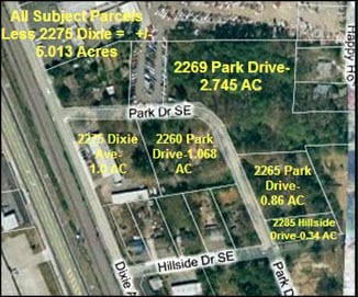
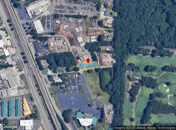
2285 Hillside Dr Se
17-0491-0-006-0
Spring Street Investments Llc
Commercialnec
Cobb
X
Georgia
13067C0119H
491
2025
0.31 AC
2025
Cumberland/Galleria
031111
Atlanta
1,156 SF
Atlanta-Sandy Springs-Roswell, GA
DEMOGRAPHICS near 2285 Hillside Dr Se
1 Mile
3 Mile
5 Mile
2024 Total Population
8,481
110,633
252,865
2029 Population
8,679
113,266
258,146
Pop Growth 2024-2029
+ 2.33%
+ 2.38%
+ 2.09%
Average Age
35
35
37
2024 Total Households
3,486
47,039
108,865
HH Growth 2024-2029
+ 2.35%
+ 2.29%
+ 2.05%
Median Household Inc
$70,833
$64,067
$77,354
Avg Household Size
2.30
2.30
2.20
2024 Avg HH Vehicles
2.00
2.00
2.00
Median Home Value
$357,499
$320,415
$353,684
Median Year Built
1975
1985
1986
Nearby Places
Map Layers
Map Styles
 Street
 Aerial
- Restaurants
- Banks
- Shops
- Fitness
- Groceries
PUBLIC TRANSPORTATION
AIRPORT
Hartsfield - Jackson Atlanta International
DRIVE
WALK
Distance
Hartsfield - Jackson Atlanta International
37 min
25.0 mi
Freight Ports
Georgia Ports - Savannah
DRIVE
WALK
Distance
Georgia Ports - Savannah
300 min
264.3 mi
Nearby Properties
Address
Land Use
TOTAL SIZE
Lot Size
Zoning
Address
Land Use
TOTAL SIZE
Lot Size
Zoning
41,500 SF
15.61 AC
RRC
Address
Land Use
TOTAL SIZE
Lot Size
Zoning
553,125 SF
42.07 AC
PRD MF
Address
Land Use
TOTAL SIZE
Lot Size
Zoning
237,743 SF
10.32 AC
RRC
Address
Land Use
TOTAL SIZE
Lot Size
Zoning
468,079 SF
31.79 AC
RMR
Address
Land Use
TOTAL SIZE
Lot Size
Zoning
583,570 SF
4.56 AC
PVC/OI
Address
Land Use
TOTAL SIZE
Lot Size
Zoning
3.51 AC
RRC
Address
Land Use
TOTAL SIZE
Lot Size
Zoning
612,660 SF
46.67 AC
RM-16
Address
Land Use
TOTAL SIZE
Lot Size
Zoning
389,428 SF
22.50 AC
RM12
Address
Land Use
TOTAL SIZE
Lot Size
Zoning
560,836 SF
60.28 AC
RM-8
Address
Land Use
TOTAL SIZE
Lot Size
Zoning
379,000 SF
29.86 AC
RM-12
Address
Land Use
TOTAL SIZE
Lot Size
Zoning
486,095 SF
5.57 AC
UC
Address
Land Use
TOTAL SIZE
Lot Size
Zoning
437,793 SF
41.12 AC
RM-16
Address
Land Use
TOTAL SIZE
Lot Size
Zoning
424,402 SF
34.46 AC
RM-12
Address
Land Use
TOTAL SIZE
Lot Size
Zoning
504,744 SF
44.36 AC
RM-12
Address
Land Use
TOTAL SIZE
Lot Size
Zoning
325,339 SF
8.52 AC
RRC
Address
Land Use
TOTAL SIZE
Lot Size
Zoning
2.96 AC
RRC
Address
Land Use
TOTAL SIZE
Lot Size
Zoning
343,488 SF
2.15 AC
RRC
Address
Land Use
TOTAL SIZE
Lot Size
Zoning
122,154 SF
3.40 AC
RRC
Address
Land Use
TOTAL SIZE
Lot Size
Zoning
85,489 SF
6.20 AC
PRD MF
Address
Land Use
TOTAL SIZE
Lot Size
Zoning
478,466 SF
25.90 AC
RM-12
Address
Land Use
TOTAL SIZE
Lot Size
Zoning
357,031 SF
10.69 AC
MU
Address
Land Use
TOTAL SIZE
Lot Size
Zoning
285,395 SF
26.58 AC
RM-12
Address
Land Use
TOTAL SIZE
Lot Size
Zoning
452,366 SF
27.27 AC
PRD MF
Address
Land Use
TOTAL SIZE
Lot Size
Zoning
374,698 SF
30.72 AC
RM-12
Address
Land Use
TOTAL SIZE
Lot Size
Zoning
477,544 SF
4.61 AC
MU
Address
Land Use
TOTAL SIZE
Lot Size
Zoning
264,878 SF
28.71 AC
RM-16
Address
Land Use
TOTAL SIZE
Lot Size
Zoning
164,980 SF
5.34 AC
RRC
Address
Land Use
TOTAL SIZE
Lot Size
Zoning
582,685 SF
37.58 AC
PVC
Address
Land Use
TOTAL SIZE
Lot Size
Zoning
385,088 SF
33.31 AC
RM-12
Address
Land Use
TOTAL SIZE
Lot Size
Zoning
343,570 SF
22.65 AC
PRD MF
The World's #1 Commercial Real Estate Marketplace
Connect with us
© 2025 CoStar Group
The information above has been obtained from sources believed reliable. While we do not doubt its accuracy we have not verified it and make no guarantee, warranty or representation about it. It is your responsibility to independently confirm its accuracy and completeness. Any projections, opinions, assumptions, or estimates used are for example only and do not represent the current or future performance of the property. The value of this transaction to you depends on tax and other factors which should be evaluated by your tax, financial, and legal advisors. You and your advisors should conduct a careful, independent investigation of the property to determine to your satisfaction the suitability of the property for your needs.