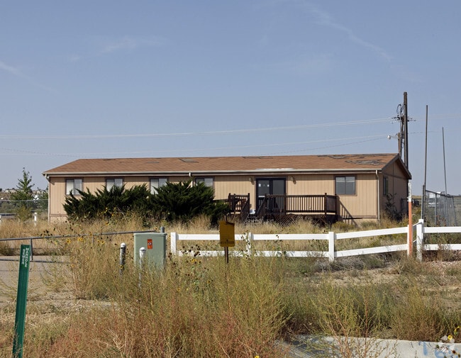
Property Record
2285 N Interstate 25, Pueblo, CO 81008


Property Detail
2285 N Interstate 25
0-5-01-0-02-001
LOT 1 BICO INDUSTRIAL PARK SUBDIVISION CONTG. 1.005,FORMERLY 05-010-00-014, 015, 034
Commercialnec
PUEBLO
I2:IND/MAN
Colorado
B and X Area of moderate flood hazard, usually the area between the limits of the 100-year and 500-year floods.
1
2025
1 AC
2025
Colorado East Area
002920
Other Market Areas
2,762 SF
Pueblo, CO
NEARBY LISTINGS FOR SALE OR LEASE
DEMOGRAPHICS near 2285 N Interstate 25
1 mile
3 mile
5 mile
2025 Total Population
857
16,469
52,806
2030 Population
871
16,498
52,806
Pop Growth 2025-2030
+ 1.63%
+ 0.18%
0.00%
Average Age
40
41
40
2025 Total Households
360
6,866
21,554
HH Growth 2025-2030
+ 1.67%
+ 0.25%
+ 0.01%
Median Household Inc
$68,732
$71,360
$63,968
Avg Household Size
2.30
2.30
2.30
2025 Avg HH Vehicles
2.00
2.00
2.00
Median Home Value
$373,912
$355,216
$299,112
Median Year Built
2006
1993
1975
Nearby Places
Map Layers
Map Styles
 Street
 Aerial
Layers
 Traffic
 Biking
Places
Listings with unknown addresses are not visible on the map
- Restaurants
- Banks
- Shops
- Fitness
- Groceries
PUBLIC TRANSPORTATION
AIRPORT
City of Colorado Springs Municipal
Drive
Walk
Distance
City of Colorado Springs Municipal
51 min
41.0 mi
Nearby Properties
Address
Land Use
TOTAL SIZE
Lot Size
Zoning
Address
Land Use
TOTAL SIZE
Lot Size
Zoning
44,544 SF
4 AC
R5:RES/MUL
Address
Land Use
TOTAL SIZE
Lot Size
Zoning
16,888 SF
5.31 AC
A-1
Address
Land Use
TOTAL SIZE
Lot Size
Zoning
265,006 SF
21.03 AC
B4:COMM/RE
Address
Land Use
TOTAL SIZE
Lot Size
Zoning
15,741 SF
24.16 AC
R5:RES/MUL
Address
Land Use
TOTAL SIZE
Lot Size
Zoning
91,409 SF
12.23 AC
B-3
Address
Land Use
TOTAL SIZE
Lot Size
Zoning
50,464 SF
9.34 AC
B4:COMM/RE
Address
Land Use
TOTAL SIZE
Lot Size
Zoning
17,956 SF
3.31 AC
R1:RES/1 F
Address
Land Use
TOTAL SIZE
Lot Size
Zoning
25,180 SF
1.83 AC
B4:COMM/RE
Address
Land Use
TOTAL SIZE
Lot Size
Zoning
20,507 SF
2.93 AC
B3:COMM/H&
Address
Land Use
TOTAL SIZE
Lot Size
Zoning
53,648 SF
2.70 AC
B-3
Address
Land Use
TOTAL SIZE
Lot Size
Zoning
202,847 SF
22.04 AC
B4:COMM/RE
Address
Land Use
TOTAL SIZE
Lot Size
Zoning
88,208 SF
11.96 AC
B-3
Address
Land Use
TOTAL SIZE
Lot Size
Zoning
104,405 SF
8.17 AC
A2:AG/1&2
Address
Land Use
TOTAL SIZE
Lot Size
Zoning
181,050 SF
12.97 AC
B3:COMM/H&
Address
Land Use
TOTAL SIZE
Lot Size
Zoning
146,292 SF
17.81 AC
B3:COMM/H&
Address
Land Use
TOTAL SIZE
Lot Size
Zoning
90,175 SF
7.86 AC
B3:COMM/H&
Address
Land Use
TOTAL SIZE
Lot Size
Zoning
26,467 SF
2.02 AC
B4:COMM/RE
Address
Land Use
TOTAL SIZE
Lot Size
Zoning
50,104 SF
6.56 AC
Address
Land Use
TOTAL SIZE
Lot Size
Zoning
40,100 SF
3.08 AC
B3:COMM/H&
Address
Land Use
TOTAL SIZE
Lot Size
Zoning
16,150 SF
1.05 AC
B3:COMM/H&
Address
Land Use
TOTAL SIZE
Lot Size
Zoning
220,512 SF
5.39 AC
B4:COMM/RE
Address
Land Use
TOTAL SIZE
Lot Size
Zoning
51,185 SF
11.26 AC
B3:COMM/H&
Address
Land Use
TOTAL SIZE
Lot Size
Zoning
81,322 SF
5.12 AC
B3:COMM/H&
Address
Land Use
TOTAL SIZE
Lot Size
Zoning
30,798 SF
2.53 AC
B4:COMM/RE
Address
Land Use
TOTAL SIZE
Lot Size
Zoning
51,748 SF
2.47 AC
B3:COMM/H&
Address
Land Use
TOTAL SIZE
Lot Size
Zoning
59,296 SF
1.58 AC
B3:COMM/H&
Address
Land Use
TOTAL SIZE
Lot Size
Zoning
55,207 SF
2.91 AC
B3:COMM/H&
Address
Land Use
TOTAL SIZE
Lot Size
Zoning
65,964 SF
2.44 AC
B3:COMM/H&
Address
Land Use
TOTAL SIZE
Lot Size
Zoning
138,008 SF
10.37 AC
B3:COMM/H&
Address
Land Use
TOTAL SIZE
Lot Size
Zoning
12,608 SF
2.50 AC
B2:COMM/SU
The World's #1 Commercial Real Estate Marketplace
Connect with us
© 2026 CoStar Group
The information above has been obtained from sources believed reliable. While we do not doubt its accuracy we have not verified it and make no guarantee, warranty or representation about it. It is your responsibility to independently confirm its accuracy and completeness. Any projections, opinions, assumptions, or estimates used are for example only and do not represent the current or future performance of the property. The value of this transaction to you depends on tax and other factors which should be evaluated by your tax, financial, and legal advisors. You and your advisors should conduct a careful, independent investigation of the property to determine to your satisfaction the suitability of the property for your needs.