Property Record
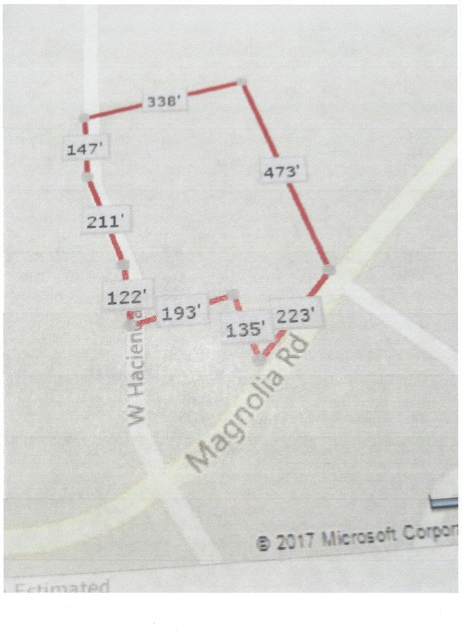
22865 W Hacienda Dr, Grass Valley, CA 95949

NEARBY LISTINGS FOR SALE OR LEASE
Property Detail
22865 W Hacienda Dr
Truckee-Grass Valley, CA
PCL 2 PM 17/245
021-730-051-000
Nevada
Commercialacreage
California
X
2
06061C0475H
4.20 AC
2024
California North Rural Area
2025
Other Market Areas
000107
DEMOGRAPHICS near 22865 W Hacienda Dr
1 Mile
3 Mile
5 Mile
2024 Total Population
2,316
8,306
20,017
2029 Population
2,307
8,373
20,532
Pop Growth 2024-2029
(0.39%)
+ 0.81%
+ 2.57%
Average Age
50
50
49
2024 Total Households
971
3,367
7,981
HH Growth 2024-2029
(0.31%)
+ 0.80%
+ 2.51%
Median Household Inc
$114,930
$104,941
$106,150
Avg Household Size
2.40
2.40
2.50
2024 Avg HH Vehicles
2.00
2.00
3.00
Median Home Value
$503,434
$556,953
$639,425
Median Year Built
1982
1981
1982
Nearby Places
Map Layers
Map Styles
 Street
 Aerial
- Restaurants
- Banks
- Shops
- Fitness
- Groceries
SALE & LEASE HISTORY
LISTING DATE
SALE/LEASE

Oct 16, 2018
For Sale
Nearby Properties
Address
Land Use
TOTAL SIZE
Lot Size
Zoning
Address
Land Use
TOTAL SIZE
Lot Size
Zoning
5.52 AC
Address
Land Use
TOTAL SIZE
Lot Size
Zoning
25,195 SF
3.20 AC
C2-SC-SP
Address
Land Use
TOTAL SIZE
Lot Size
Zoning
58,478 SF
5.31 AC
C1-SC-SP
Address
Land Use
TOTAL SIZE
Lot Size
Zoning
47,083 SF
11.43 AC
C2SCSP
Address
Land Use
TOTAL SIZE
Lot Size
Zoning
3,351 SF
1.41 AC
C2-SC-SP
Address
Land Use
TOTAL SIZE
Lot Size
Zoning
43,150 SF
5.61 AC
RA-1.5
Address
Land Use
TOTAL SIZE
Lot Size
Zoning
36,632 SF
11.99 AC
RA-5
Address
Land Use
TOTAL SIZE
Lot Size
Zoning
0.96 AC
Address
Land Use
TOTAL SIZE
Lot Size
Zoning
33,600 SF
6.39 AC
OSSC
Address
Land Use
TOTAL SIZE
Lot Size
Zoning
3,600 SF
170.26 AC
RECPDSP
Address
Land Use
TOTAL SIZE
Lot Size
Zoning
14,085 SF
1.58 AC
C2-SC-SP
Address
Land Use
TOTAL SIZE
Lot Size
Zoning
2,980 SF
1.34 AC
C2-SC-SP
Address
Land Use
TOTAL SIZE
Lot Size
Zoning
31,600 SF
1.93 AC
M1-SC-SP
Address
Land Use
TOTAL SIZE
Lot Size
Zoning
184.37 AC
OS
Address
Land Use
TOTAL SIZE
Lot Size
Zoning
8,504 SF
1.23 AC
Address
Land Use
TOTAL SIZE
Lot Size
Zoning
30,520 SF
6.16 AC
BP-SC-SP
Address
Land Use
TOTAL SIZE
Lot Size
Zoning
3,192 SF
3.88 AC
C2-SC-SP
Address
Land Use
TOTAL SIZE
Lot Size
Zoning
8,000 SF
1.65 AC
M1-SC-SP
Address
Land Use
TOTAL SIZE
Lot Size
Zoning
12,695 SF
1.15 AC
BP-SC
Address
Land Use
TOTAL SIZE
Lot Size
Zoning
1.95 AC
Address
Land Use
TOTAL SIZE
Lot Size
Zoning
3,584 SF
5.07 AC
RA-1.5
Address
Land Use
TOTAL SIZE
Lot Size
Zoning
14,562 SF
3.75 AC
C1-SC-SP
Address
Land Use
TOTAL SIZE
Lot Size
Zoning
82.04 AC
RA-3-PD
Address
Land Use
TOTAL SIZE
Lot Size
Zoning
4.12 AC
OS
Address
Land Use
TOTAL SIZE
Lot Size
Zoning
2,500 SF
0.80 AC
C2-SC-SP
Address
Land Use
TOTAL SIZE
Lot Size
Zoning
23,374 SF
2.85 AC
BP-SC
Address
Land Use
TOTAL SIZE
Lot Size
Zoning
3,200 SF
3.82 AC
AG5SC
Address
Land Use
TOTAL SIZE
Lot Size
Zoning
Address
Land Use
TOTAL SIZE
Lot Size
Zoning
2,424 SF
5.82 AC
AG5SC
Address
Land Use
TOTAL SIZE
Lot Size
Zoning
0.45 AC
R1-PD-SP
The World's #1 Commercial Real Estate Marketplace
Connect with us
© 2026 CoStar Group
The information above has been obtained from sources believed reliable. While we do not doubt its accuracy we have not verified it and make no guarantee, warranty or representation about it. It is your responsibility to independently confirm its accuracy and completeness. Any projections, opinions, assumptions, or estimates used are for example only and do not represent the current or future performance of the property. The value of this transaction to you depends on tax and other factors which should be evaluated by your tax, financial, and legal advisors. You and your advisors should conduct a careful, independent investigation of the property to determine to your satisfaction the suitability of the property for your needs.