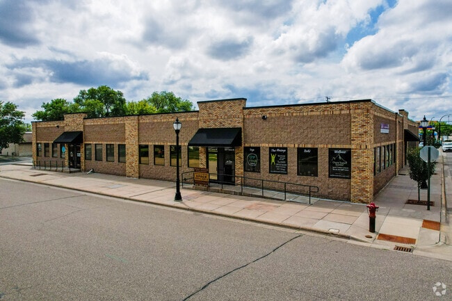
Property Record
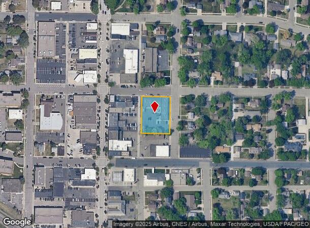
229 1St Ave Ne, Osseo, MN 55369
NEARBY LISTINGS FOR SALE OR LEASE
Property Detail
229 1St Ave Ne
Minneapolis-St. Paul-Bloomington, MN-WI
Cic No 0994 First Ave Commons Condo
18-119-21-23-0199
A CIC NO 0994 FIRST AVE COMMONS CONDO UNIT NO 2 IRREGULAR
Commercialnec
Hennepin
X
Minnesota
27053C0182F
0.71 AC
2024
Northwest
2024
Minneapolis/St Paul
026702
DEMOGRAPHICS near 229 1St Ave Ne
1 Mile
3 Mile
5 Mile
2024 Total Population
4,104
65,587
189,272
2029 Population
4,046
64,575
186,596
Pop Growth 2024-2029
(1.41%)
(1.54%)
(1.41%)
Average Age
43
39
39
2024 Total Households
1,773
24,036
69,188
HH Growth 2024-2029
(1.75%)
(1.69%)
(1.49%)
Median Household Inc
$73,971
$98,371
$89,034
Avg Household Size
2.20
2.70
2.60
2024 Avg HH Vehicles
2.00
2.00
2.00
Median Home Value
$256,865
$306,769
$296,989
Median Year Built
1970
1986
1983
Nearby Places
Map Layers
Map Styles
 Street
 Aerial
- Restaurants
- Banks
- Shops
- Fitness
- Groceries
PUBLIC TRANSPORTATION
COMMUTER RAIL
Anoka Station (Northstar Corridor - Northstar Commuter Rail)
DRIVE
WALK
Distance
Anoka Station (Northstar Corridor - Northstar Commuter Rail)
15 min
7.4 mi
Coon Rapids-Riverdale Station (Northstar Corridor - Northstar Commuter Rail)
DRIVE
WALK
Distance
Coon Rapids-Riverdale Station (Northstar Corridor - Northstar Commuter Rail)
18 min
9.1 mi
AIRPORT
Minneapolis-St Paul International/Wold-Chamberlain
DRIVE
WALK
Distance
Minneapolis-St Paul International/Wold-Chamberlain
39 min
27.1 mi
Freight Ports
Port Milwaukee
DRIVE
WALK
Distance
Port Milwaukee
391 min
352.6 mi
SALE & LEASE HISTORY
LISTING DATE
SALE/LEASE

Nov 30, 2018
For Lease
Apr 09, 2022
For Lease
Nearby Properties
Address
Land Use
TOTAL SIZE
Lot Size
Zoning
Address
Land Use
TOTAL SIZE
Lot Size
Zoning
69.46 AC
Address
Land Use
TOTAL SIZE
Lot Size
Zoning
Address
Land Use
TOTAL SIZE
Lot Size
Zoning
52,110 SF
35.71 AC
Address
Land Use
TOTAL SIZE
Lot Size
Zoning
10.90 AC
Address
Land Use
TOTAL SIZE
Lot Size
Zoning
297,060 SF
19.17 AC
Address
Land Use
TOTAL SIZE
Lot Size
Zoning
7.53 AC
Address
Land Use
TOTAL SIZE
Lot Size
Zoning
Address
Land Use
TOTAL SIZE
Lot Size
Zoning
Address
Land Use
TOTAL SIZE
Lot Size
Zoning
8.11 AC
Address
Land Use
TOTAL SIZE
Lot Size
Zoning
42.65 AC
Address
Land Use
TOTAL SIZE
Lot Size
Zoning
7.50 AC
Address
Land Use
TOTAL SIZE
Lot Size
Zoning
Address
Land Use
TOTAL SIZE
Lot Size
Zoning
Address
Land Use
TOTAL SIZE
Lot Size
Zoning
409,456 SF
12.40 AC
Address
Land Use
TOTAL SIZE
Lot Size
Zoning
Address
Land Use
TOTAL SIZE
Lot Size
Zoning
196,970 SF
15.63 AC
Address
Land Use
TOTAL SIZE
Lot Size
Zoning
24.75 AC
Address
Land Use
TOTAL SIZE
Lot Size
Zoning
16.54 AC
Address
Land Use
TOTAL SIZE
Lot Size
Zoning
58,119 SF
18.55 AC
Address
Land Use
TOTAL SIZE
Lot Size
Zoning
14.72 AC
Address
Land Use
TOTAL SIZE
Lot Size
Zoning
21.53 AC
Address
Land Use
TOTAL SIZE
Lot Size
Zoning
4.51 AC
Address
Land Use
TOTAL SIZE
Lot Size
Zoning
Address
Land Use
TOTAL SIZE
Lot Size
Zoning
1.99 AC
Address
Land Use
TOTAL SIZE
Lot Size
Zoning
Address
Land Use
TOTAL SIZE
Lot Size
Zoning
35.38 AC
Address
Land Use
TOTAL SIZE
Lot Size
Zoning
13.63 AC
Address
Land Use
TOTAL SIZE
Lot Size
Zoning
90,700 SF
17.07 AC
Address
Land Use
TOTAL SIZE
Lot Size
Zoning
Address
Land Use
TOTAL SIZE
Lot Size
Zoning
18.59 AC
The World's #1 Commercial Real Estate Marketplace
Connect with us
© 2025 CoStar Group
The information above has been obtained from sources believed reliable. While we do not doubt its accuracy we have not verified it and make no guarantee, warranty or representation about it. It is your responsibility to independently confirm its accuracy and completeness. Any projections, opinions, assumptions, or estimates used are for example only and do not represent the current or future performance of the property. The value of this transaction to you depends on tax and other factors which should be evaluated by your tax, financial, and legal advisors. You and your advisors should conduct a careful, independent investigation of the property to determine to your satisfaction the suitability of the property for your needs.