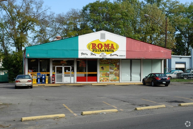
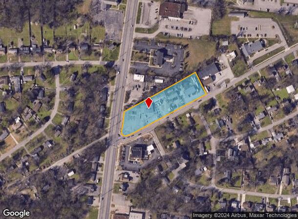
Property Record
229 Donelson Pike, Nashville, TN 37214

NEARBY LISTINGS FOR SALE OR LEASE
Property Detail
229 Donelson Pike
Nashville-Davidson--Murfreesboro--Franklin, TN
Herbert D Gentry Land
096-05-0-133
LOT 1 HERBERT D. GENTRY LAND
Stripcommercialcenter
Davidson
X
Tennessee
47037C0266H
1
2025
2.06 AC
2025
Donelson-Hermitage
015501
Nashville
2,100 SF
DEMOGRAPHICS near 229 Donelson Pike
1 Mile
3 Mile
5 Mile
2024 Total Population
5,392
33,914
110,730
2029 Population
5,248
33,240
108,551
Pop Growth 2024-2029
(2.67%)
(1.99%)
(1.97%)
Average Age
42
40
38
2024 Total Households
2,513
15,512
48,282
HH Growth 2024-2029
(3.10%)
(2.35%)
(2.30%)
Median Household Inc
$61,402
$63,195
$65,993
Avg Household Size
2.10
2.10
2.20
2024 Avg HH Vehicles
2.00
2.00
2.00
Median Home Value
$302,224
$301,260
$331,857
Median Year Built
1959
1980
1979
Nearby Places
Map Layers
Map Styles
 Street
 Aerial
- Restaurants
- Banks
- Shops
- Fitness
- Groceries
PUBLIC TRANSPORTATION
TRANSIT/SUBWAY
Donelson (East Corridor Line - Tennessee Regional Transportation Authority Music City Star (Music City Star))
DRIVE
WALK
Distance
Donelson (East Corridor Line - Tennessee Regional Transportation Authority Music City Star (Music City Star))
3 min
14 min
0.7 mi
COMMUTER RAIL
Donelson (East Corridor Line - Tennessee Regional Transportation Authority Music City Star (Music City Star))
DRIVE
WALK
Distance
Donelson (East Corridor Line - Tennessee Regional Transportation Authority Music City Star (Music City Star))
3 min
14 min
0.7 mi
Hermitage (East Corridor Line - Tennessee Regional Transportation Authority Music City Star (Music City Star))
DRIVE
WALK
Distance
Hermitage (East Corridor Line - Tennessee Regional Transportation Authority Music City Star (Music City Star))
11 min
5.7 mi
AIRPORT
Nashville International
DRIVE
WALK
Distance
Nashville International
6 min
3.6 mi
SALE & LEASE HISTORY
LISTING DATE
SALE/LEASE

Jan 01, 2023
For Lease
Feb 11, 2025
For Lease
Nearby Properties
Address
Land Use
TOTAL SIZE
Lot Size
Zoning
Address
Land Use
TOTAL SIZE
Lot Size
Zoning
155,763 SF
2,110.61 AC
MULTI-ZONE
Address
Land Use
TOTAL SIZE
Lot Size
Zoning
24,800 SF
1,167.94 AC
MULTI-ZONE
Address
Land Use
TOTAL SIZE
Lot Size
Zoning
291,852 SF
14.94 AC
ORI
Address
Land Use
TOTAL SIZE
Lot Size
Zoning
313,498 SF
23.59 AC
ORI
Address
Land Use
TOTAL SIZE
Lot Size
Zoning
186,477 SF
3.31 AC
Address
Land Use
TOTAL SIZE
Lot Size
Zoning
9,956 SF
81.09 AC
RM9
Address
Land Use
TOTAL SIZE
Lot Size
Zoning
102,162 SF
25.71 AC
RM9
Address
Land Use
TOTAL SIZE
Lot Size
Zoning
571,677 SF
28.37 AC
MULTI-ZONE
Address
Land Use
TOTAL SIZE
Lot Size
Zoning
237,496 SF
5.41 AC
ORI
Address
Land Use
TOTAL SIZE
Lot Size
Zoning
261,082 SF
4.78 AC
CS
Address
Land Use
TOTAL SIZE
Lot Size
Zoning
14,352 SF
24.19 AC
RM15
Address
Land Use
TOTAL SIZE
Lot Size
Zoning
49,660 SF
16.96 AC
MULTIZONE
Address
Land Use
TOTAL SIZE
Lot Size
Zoning
144,730 SF
13.13 AC
Address
Land Use
TOTAL SIZE
Lot Size
Zoning
292,815 SF
10.04 AC
ORI
Address
Land Use
TOTAL SIZE
Lot Size
Zoning
40,236 SF
34.21 AC
IR
Address
Land Use
TOTAL SIZE
Lot Size
Zoning
18,522 SF
22.42 AC
MULTI-ZONE
Address
Land Use
TOTAL SIZE
Lot Size
Zoning
52,305 SF
25.71 AC
MULTI-ZONE
Address
Land Use
TOTAL SIZE
Lot Size
Zoning
248,573 SF
25.36 AC
OL
Address
Land Use
TOTAL SIZE
Lot Size
Zoning
21,104 SF
21.07 AC
RM15
Address
Land Use
TOTAL SIZE
Lot Size
Zoning
51,846 SF
6.37 AC
MULTIZONE
Address
Land Use
TOTAL SIZE
Lot Size
Zoning
72,752 SF
4.56 AC
ORI
Address
Land Use
TOTAL SIZE
Lot Size
Zoning
15,044 SF
20.63 AC
RM20
Address
Land Use
TOTAL SIZE
Lot Size
Zoning
37,050 SF
8.78 AC
OR20
Address
Land Use
TOTAL SIZE
Lot Size
Zoning
16,890 SF
8.28 AC
CS
Address
Land Use
TOTAL SIZE
Lot Size
Zoning
14,374 SF
19.16 AC
RM15
Address
Land Use
TOTAL SIZE
Lot Size
Zoning
185,608 SF
8.60 AC
ORI
Address
Land Use
TOTAL SIZE
Lot Size
Zoning
8,626 SF
15.65 AC
OR20
Address
Land Use
TOTAL SIZE
Lot Size
Zoning
43,030 SF
7 AC
CL
Address
Land Use
TOTAL SIZE
Lot Size
Zoning
10,704 SF
16.34 AC
R10
Address
Land Use
TOTAL SIZE
Lot Size
Zoning
62,024 SF
15.97 AC
SCC
The World's #1 Commercial Real Estate Marketplace
Connect with us
© 2026 CoStar Group
The information above has been obtained from sources believed reliable. While we do not doubt its accuracy we have not verified it and make no guarantee, warranty or representation about it. It is your responsibility to independently confirm its accuracy and completeness. Any projections, opinions, assumptions, or estimates used are for example only and do not represent the current or future performance of the property. The value of this transaction to you depends on tax and other factors which should be evaluated by your tax, financial, and legal advisors. You and your advisors should conduct a careful, independent investigation of the property to determine to your satisfaction the suitability of the property for your needs.