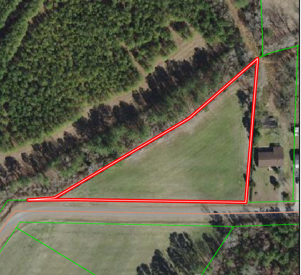
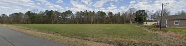
Property Record
Myrtle Rd, Selma, NC 27576

Property Detail
Myrtle Rd
Raleigh-Cary, NC
LOT 4 OLIVER PB24/201 261407-14
12052003E
JOHNSTON
Vacantlandnec
North Carolina
IND
4
B and X Area of moderate flood hazard, usually the area between the limits of the 100-year and 500-year floods.
2.19 AC
2025
Johnston County
2025
Raleigh/Durham
040301
NEARBY LISTINGS FOR SALE OR LEASE
DEMOGRAPHICS near Myrtle Rd
1 mile
3 mile
5 mile
2025 Total Population
3,326
13,580
28,818
2030 Population
3,710
15,187
32,265
Pop Growth 2025-2030
+ 11.55%
+ 11.83%
+ 11.96%
Average Age
38
38
40
2025 Total Households
1,308
5,145
10,975
HH Growth 2025-2030
+ 11.54%
+ 11.86%
+ 12.06%
Median Household Inc
$53,182
$49,963
$54,301
Avg Household Size
2.50
2.60
2.50
2025 Avg HH Vehicles
1.00
2.00
2.00
Median Home Value
$164,108
$193,503
$212,824
Median Year Built
1978
1985
1986
Nearby Places
Map Layers
Map Styles
 Street
 Aerial
Transit
 Traffic
 Biking
Places
Listings with unknown addresses are not visible on the map
- Restaurants
- Banks
- Shops
- Fitness
- Groceries
PUBLIC TRANSPORTATION
COMMUTER RAIL
Selma (Carolinian - Amtrak, Palmetto - Amtrak)
Drive
Walk
Distance
Selma (Carolinian - Amtrak, Palmetto - Amtrak)
1 min
12 min
0.6 mi
Freight Ports
Port of Wilmington
Drive
Walk
Distance
Port of Wilmington
136 min
112.5 mi
SALE & LEASE HISTORY
LISTING DATE
SALE/LEASE

Oct 28, 2023
For Sale
May 04, 2023
For Sale
Dec 29, 2022
For Sale
Dec 08, 2025
For Lease
Nearby Properties
Address
Land Use
TOTAL SIZE
Lot Size
Zoning
Address
Land Use
TOTAL SIZE
Lot Size
Zoning
202,660 SF
90.41 AC
IND
Address
Land Use
TOTAL SIZE
Lot Size
Zoning
16.84 AC
OFF
Address
Land Use
TOTAL SIZE
Lot Size
Zoning
158,778 SF
35.88 AC
OFF
Address
Land Use
TOTAL SIZE
Lot Size
Zoning
85,041 SF
35.02 AC
SUP
Address
Land Use
TOTAL SIZE
Lot Size
Zoning
45,000 SF
99.14 AC
IND
Address
Land Use
TOTAL SIZE
Lot Size
Zoning
697,252 SF
114.71 AC
IND
Address
Land Use
TOTAL SIZE
Lot Size
Zoning
6,440 SF
16.82 AC
RES
Address
Land Use
TOTAL SIZE
Lot Size
Zoning
197,722 SF
25.55 AC
COM
Address
Land Use
TOTAL SIZE
Lot Size
Zoning
134,742 SF
8.20 AC
IND
Address
Land Use
TOTAL SIZE
Lot Size
Zoning
24,830 SF
28.89 AC
OFF
Address
Land Use
TOTAL SIZE
Lot Size
Zoning
39,191 SF
7.46 AC
COM
Address
Land Use
TOTAL SIZE
Lot Size
Zoning
72,165 SF
24.21 AC
COM
Address
Land Use
TOTAL SIZE
Lot Size
Zoning
78,588 SF
7.99 AC
SUP
Address
Land Use
TOTAL SIZE
Lot Size
Zoning
102,276 SF
35 AC
RES
Address
Land Use
TOTAL SIZE
Lot Size
Zoning
120,872 SF
13.57 AC
COM
Address
Land Use
TOTAL SIZE
Lot Size
Zoning
54,009 SF
2.08 AC
COM
Address
Land Use
TOTAL SIZE
Lot Size
Zoning
63,415 SF
5.45 AC
COM
Address
Land Use
TOTAL SIZE
Lot Size
Zoning
112,276 SF
10.57 AC
COM
Address
Land Use
TOTAL SIZE
Lot Size
Zoning
30,370 SF
8.43 AC
COM
Address
Land Use
TOTAL SIZE
Lot Size
Zoning
2,065 SF
24.99 AC
COM
Address
Land Use
TOTAL SIZE
Lot Size
Zoning
57,774 SF
3.79 AC
COM
Address
Land Use
TOTAL SIZE
Lot Size
Zoning
3,600 SF
20.26 AC
RES
Address
Land Use
TOTAL SIZE
Lot Size
Zoning
32,348 SF
5.45 AC
COM
Address
Land Use
TOTAL SIZE
Lot Size
Zoning
12,360 SF
7.27 AC
COM
Address
Land Use
TOTAL SIZE
Lot Size
Zoning
1,890 SF
8.08 AC
COM
Address
Land Use
TOTAL SIZE
Lot Size
Zoning
42,888 SF
1.98 AC
COM
Address
Land Use
TOTAL SIZE
Lot Size
Zoning
19,960 SF
5.29 AC
COM
Address
Land Use
TOTAL SIZE
Lot Size
Zoning
6,695 SF
8.17 AC
COM
The World's #1 Commercial Real Estate Marketplace
Connect with us
© 2026 CoStar Group
The information above has been obtained from sources believed reliable. While we do not doubt its accuracy we have not verified it and make no guarantee, warranty or representation about it. It is your responsibility to independently confirm its accuracy and completeness. Any projections, opinions, assumptions, or estimates used are for example only and do not represent the current or future performance of the property. The value of this transaction to you depends on tax and other factors which should be evaluated by your tax, financial, and legal advisors. You and your advisors should conduct a careful, independent investigation of the property to determine to your satisfaction the suitability of the property for your needs.