Property Record
229 S Padre Island Dr, Corpus Christi, TX 78405


NEARBY LISTINGS FOR SALE OR LEASE
-
-
View all Corpus Christi listings for lease on LoopNet.com
Property Detail
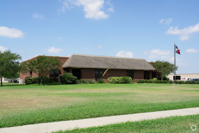
229 S Padre Island Dr
Corpus Christi, TX
Industrial Technology Park Unit 1
200077503
INDUSTRIAL TECHNOLOGY PARK UNIT 1 BLK 3 LOT 5R
Commercialnec
Nueces
X
Texas
48355C0315G
5r
2024
2.20 AC
2025
Southwest
000800
Corpus Christi
4,516 SF
DEMOGRAPHICS near 229 S Padre Island Dr
1 Mile
3 Mile
5 Mile
2024 Total Population
1,013
34,022
106,831
2029 Population
998
33,615
105,907
Pop Growth 2024-2029
(1.48%)
(1.20%)
(0.86%)
Average Age
38
38
39
2024 Total Households
331
11,693
37,934
HH Growth 2024-2029
(1.51%)
(1.32%)
(0.88%)
Median Household Inc
$22,777
$39,871
$41,727
Avg Household Size
2.60
2.80
2.70
2024 Avg HH Vehicles
1.00
2.00
2.00
Median Home Value
$108,139
$70,315
$96,166
Median Year Built
1988
1968
1962
Nearby Places
Map Layers
Map Styles
 Street
 Aerial
- Restaurants
- Banks
- Shops
- Fitness
- Groceries
PUBLIC TRANSPORTATION
AIRPORT
Corpus Christi International
DRIVE
WALK
Distance
Corpus Christi International
11 min
5.4 mi
Freight Ports
Port of Corpus Christi
DRIVE
WALK
Distance
Port of Corpus Christi
12 min
6.8 mi
SALE & LEASE HISTORY
LISTING DATE
SALE/LEASE

Sep 25, 2016
For Lease
Nearby Properties
Address
Land Use
TOTAL SIZE
Lot Size
Zoning
Address
Land Use
TOTAL SIZE
Lot Size
Zoning
382,448 SF
14.98 AC
Address
Land Use
TOTAL SIZE
Lot Size
Zoning
174,650 SF
1.95 AC
I3
Address
Land Use
TOTAL SIZE
Lot Size
Zoning
233,436 SF
Address
Land Use
TOTAL SIZE
Lot Size
Zoning
278,919 SF
39.27 AC
R1B
Address
Land Use
TOTAL SIZE
Lot Size
Zoning
105,979 SF
25 AC
I2SP92
Address
Land Use
TOTAL SIZE
Lot Size
Zoning
74,247 SF
6.39 AC
Address
Land Use
TOTAL SIZE
Lot Size
Zoning
67,009 SF
6.99 AC
R1B
Address
Land Use
TOTAL SIZE
Lot Size
Zoning
85,871 SF
18.68 AC
R1B
Address
Land Use
TOTAL SIZE
Lot Size
Zoning
11,109 SF
76.58 AC
R1B
Address
Land Use
TOTAL SIZE
Lot Size
Zoning
89,537 SF
11.35 AC
R1B
Address
Land Use
TOTAL SIZE
Lot Size
Zoning
83,835 SF
19.14 AC
Address
Land Use
TOTAL SIZE
Lot Size
Zoning
101,912 SF
13.89 AC
I-2
Address
Land Use
TOTAL SIZE
Lot Size
Zoning
74,261 SF
4.44 AC
R1B
Address
Land Use
TOTAL SIZE
Lot Size
Zoning
105.49 AC
R1B
Address
Land Use
TOTAL SIZE
Lot Size
Zoning
42,984 SF
5.20 AC
Address
Land Use
TOTAL SIZE
Lot Size
Zoning
129,210 SF
11.63 AC
R1B
Address
Land Use
TOTAL SIZE
Lot Size
Zoning
83,499 SF
5.38 AC
III
Address
Land Use
TOTAL SIZE
Lot Size
Zoning
95,860 SF
10.80 AC
R1B
Address
Land Use
TOTAL SIZE
Lot Size
Zoning
25,998 SF
31.72 AC
R1B
Address
Land Use
TOTAL SIZE
Lot Size
Zoning
28,410 SF
8.55 AC
Address
Land Use
TOTAL SIZE
Lot Size
Zoning
72,689 SF
4.07 AC
B-4&B-1
Address
Land Use
TOTAL SIZE
Lot Size
Zoning
97,550 SF
9.53 AC
B-4
Address
Land Use
TOTAL SIZE
Lot Size
Zoning
57,600 SF
9.97 AC
I2
Address
Land Use
TOTAL SIZE
Lot Size
Zoning
162,114 SF
13.15 AC
Address
Land Use
TOTAL SIZE
Lot Size
Zoning
122,706 SF
25.85 AC
R1B
Address
Land Use
TOTAL SIZE
Lot Size
Zoning
83,539 SF
13.77 AC
I2
Address
Land Use
TOTAL SIZE
Lot Size
Zoning
108,360 SF
8.12 AC
B4
Address
Land Use
TOTAL SIZE
Lot Size
Zoning
131,238 SF
16.51 AC
I-2
Address
Land Use
TOTAL SIZE
Lot Size
Zoning
40,952 SF
4.70 AC
B-4
Address
Land Use
TOTAL SIZE
Lot Size
Zoning
61,226 SF
2.99 AC
R-1B
The World's #1 Commercial Real Estate Marketplace
Connect with us
© 2026 CoStar Group
The information above has been obtained from sources believed reliable. While we do not doubt its accuracy we have not verified it and make no guarantee, warranty or representation about it. It is your responsibility to independently confirm its accuracy and completeness. Any projections, opinions, assumptions, or estimates used are for example only and do not represent the current or future performance of the property. The value of this transaction to you depends on tax and other factors which should be evaluated by your tax, financial, and legal advisors. You and your advisors should conduct a careful, independent investigation of the property to determine to your satisfaction the suitability of the property for your needs.