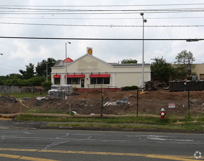
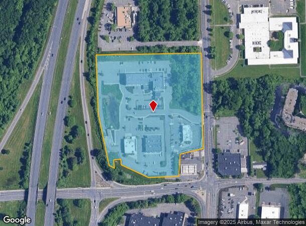
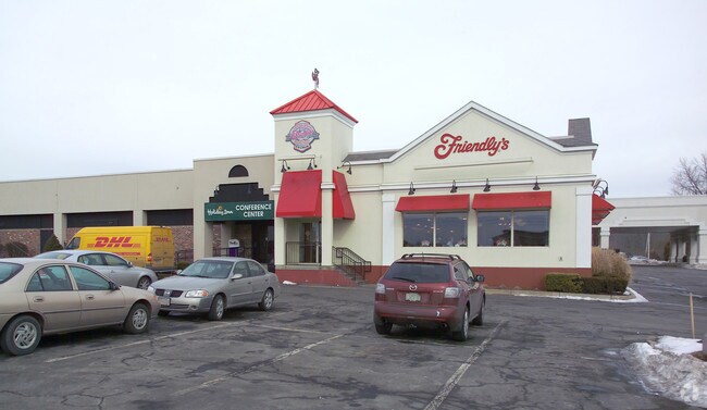
Property Record
229 Whiting Farms Rd, Holyoke, MA 01040
NEARBY LISTINGS FOR SALE OR LEASE
Property Detail
229 Whiting Farms Rd
HOLY-000174-000000-000013
Hampden
Commercialnec
Massachusetts
X
13
25013C0192E
8.84 AC
2024
Hampden County
2025
Hartford
812103
Springfield, MA
139,546 SF
DEMOGRAPHICS near 229 Whiting Farms Rd
1 Mile
3 Mile
5 Mile
2024 Total Population
5,172
63,074
157,698
2029 Population
5,092
62,037
152,685
Pop Growth 2024-2029
(1.55%)
(1.64%)
(3.18%)
Average Age
45
40
41
2024 Total Households
2,064
26,270
65,187
HH Growth 2024-2029
(1.60%)
(1.69%)
(3.34%)
Median Household Inc
$52,822
$48,091
$54,726
Avg Household Size
2.20
2.30
2.30
2024 Avg HH Vehicles
2.00
1.00
1.00
Median Home Value
$233,515
$239,896
$244,387
Median Year Built
1965
1952
1955
Nearby Places
Map Layers
Map Styles
 Street
 Aerial
- Restaurants
- Banks
- Shops
- Fitness
- Groceries
PUBLIC TRANSPORTATION
COMMUTER RAIL
Holyoke Amtrak (Valley Flyer - Amtrak, Vermonter - Amtrak)
DRIVE
WALK
Distance
Holyoke Amtrak (Valley Flyer - Amtrak, Vermonter - Amtrak)
7 min
3.6 mi
Springfield (Amtrak Hartford Line - Amtrak, Hartford Line - Amtrak, Lake Shore Limited - Amtrak, Northeast Regional - Amtrak, Valley Flyer - Amtrak, Vermonter - Amtrak)
DRIVE
WALK
Distance
Springfield (Amtrak Hartford Line - Amtrak, Hartford Line - Amtrak, Lake Shore Limited - Amtrak, Northeast Regional - Amtrak, Valley Flyer - Amtrak, Vermonter - Amtrak)
11 min
7.1 mi
AIRPORT
Bradley International
DRIVE
WALK
Distance
Bradley International
39 min
18.7 mi
Freight Ports
Port of New Haven
DRIVE
WALK
Distance
Port of New Haven
92 min
71.4 mi
Nearby Properties
Address
Land Use
TOTAL SIZE
Lot Size
Zoning
Address
Land Use
TOTAL SIZE
Lot Size
Zoning
50.97 AC
BH
Address
Land Use
TOTAL SIZE
Lot Size
Zoning
22.15 AC
R-1A
Address
Land Use
TOTAL SIZE
Lot Size
Zoning
21.80 AC
106
Address
Land Use
TOTAL SIZE
Lot Size
Zoning
29.88 AC
105
Address
Land Use
TOTAL SIZE
Lot Size
Zoning
189,022 SF
10.62 AC
RA
Address
Land Use
TOTAL SIZE
Lot Size
Zoning
138,504 SF
13.18 AC
RO
Address
Land Use
TOTAL SIZE
Lot Size
Zoning
17.72 AC
R-2
Address
Land Use
TOTAL SIZE
Lot Size
Zoning
171,241 SF
18.94 AC
106
Address
Land Use
TOTAL SIZE
Lot Size
Zoning
30.45 AC
106
Address
Land Use
TOTAL SIZE
Lot Size
Zoning
1.50 AC
105
Address
Land Use
TOTAL SIZE
Lot Size
Zoning
12.90 AC
IP
Address
Land Use
TOTAL SIZE
Lot Size
Zoning
2.41 AC
DR
Address
Land Use
TOTAL SIZE
Lot Size
Zoning
17.64 AC
105
Address
Land Use
TOTAL SIZE
Lot Size
Zoning
136,654 SF
11.71 AC
BG
Address
Land Use
TOTAL SIZE
Lot Size
Zoning
8.16 AC
RM40
Address
Land Use
TOTAL SIZE
Lot Size
Zoning
16.38 AC
RA
Address
Land Use
TOTAL SIZE
Lot Size
Zoning
72,239 SF
13.87 AC
R-1A
Address
Land Use
TOTAL SIZE
Lot Size
Zoning
908.80 AC
RA
Address
Land Use
TOTAL SIZE
Lot Size
Zoning
161,029 SF
9.97 AC
RA
Address
Land Use
TOTAL SIZE
Lot Size
Zoning
138,289 SF
22.79 AC
IG
Address
Land Use
TOTAL SIZE
Lot Size
Zoning
207,672 SF
18.62 AC
IP
Address
Land Use
TOTAL SIZE
Lot Size
Zoning
4.66 AC
105
Address
Land Use
TOTAL SIZE
Lot Size
Zoning
50,912 SF
12.53 AC
Address
Land Use
TOTAL SIZE
Lot Size
Zoning
196,705 SF
21.45 AC
RM20
Address
Land Use
TOTAL SIZE
Lot Size
Zoning
201,410 SF
13.16 AC
RM20
Address
Land Use
TOTAL SIZE
Lot Size
Zoning
191,133 SF
12.28 AC
RM-2
Address
Land Use
TOTAL SIZE
Lot Size
Zoning
45,984 SF
8.98 AC
Address
Land Use
TOTAL SIZE
Lot Size
Zoning
201,953 SF
5.64 AC
BH
Address
Land Use
TOTAL SIZE
Lot Size
Zoning
26.98 AC
BG
Address
Land Use
TOTAL SIZE
Lot Size
Zoning
47,908 SF
7.12 AC
101
The World's #1 Commercial Real Estate Marketplace
Connect with us
© 2026 CoStar Group
The information above has been obtained from sources believed reliable. While we do not doubt its accuracy we have not verified it and make no guarantee, warranty or representation about it. It is your responsibility to independently confirm its accuracy and completeness. Any projections, opinions, assumptions, or estimates used are for example only and do not represent the current or future performance of the property. The value of this transaction to you depends on tax and other factors which should be evaluated by your tax, financial, and legal advisors. You and your advisors should conduct a careful, independent investigation of the property to determine to your satisfaction the suitability of the property for your needs.