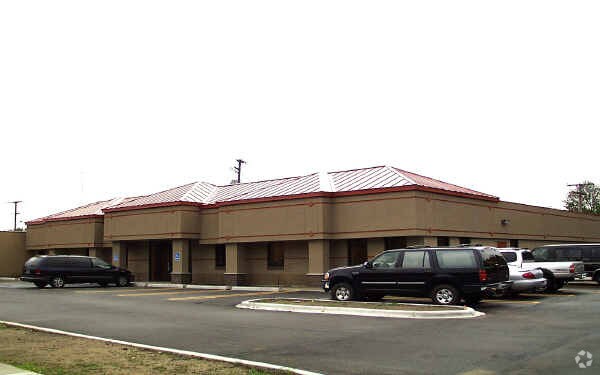
Property Record
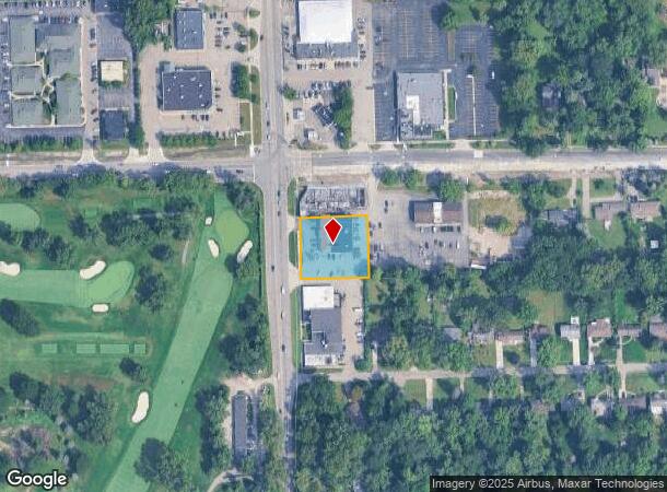
22972 Lahser Rd, Southfield, MI 48033
NEARBY LISTINGS FOR SALE OR LEASE
Property Detail
22972 Lahser Rd
Detroit-Warren-Dearborn, MI
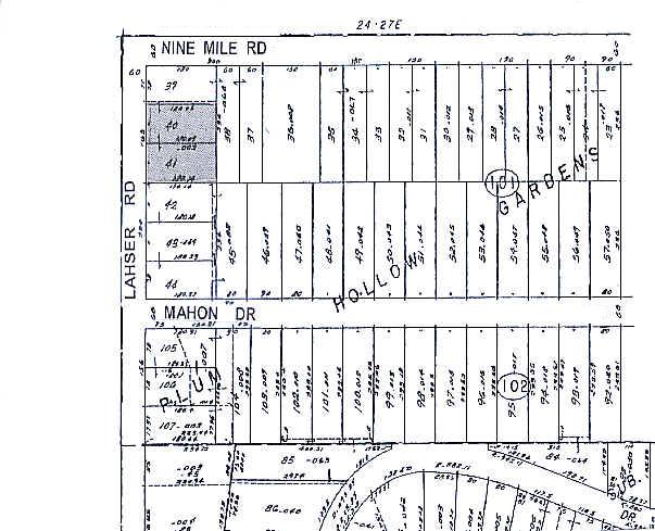
Plum Hollow Gardens Sub
24-34-101-002
T1N,R10E,SEC 34 40-1 PLUM HOLLOW GARDENS S 7 FT OF LOT 39 & ALL OF LOTS 40 & 41
Medicalbuilding
Oakland
X
Michigan
26163C0060E
39-41
2024
0.67 AC
2022
Southfield
162400
Detroit
7,920 SF
DEMOGRAPHICS near 22972 Lahser Rd
1 Mile
3 Mile
5 Mile
2024 Total Population
6,178
96,686
297,257
2029 Population
6,136
95,007
291,407
Pop Growth 2024-2029
(0.68%)
(1.74%)
(1.97%)
Average Age
40
41
41
2024 Total Households
2,579
41,330
124,023
HH Growth 2024-2029
(0.66%)
(1.78%)
(1.98%)
Median Household Inc
$60,615
$49,211
$56,412
Avg Household Size
2.20
2.20
2.30
2024 Avg HH Vehicles
2.00
1.00
2.00
Median Home Value
$149,638
$140,865
$160,206
Median Year Built
1966
1959
1957
Nearby Places
Map Layers
Map Styles
 Street
 Aerial
- Restaurants
- Banks
- Shops
- Fitness
- Groceries
PUBLIC TRANSPORTATION
COMMUTER RAIL
DRIVE
WALK
Distance
17 min
8.0 mi
AIRPORT
Detroit Metro Wayne County
DRIVE
WALK
Distance
Detroit Metro Wayne County
41 min
22.3 mi
Windsor International
DRIVE
WALK
Distance
Windsor International
49 min
26.5 mi
Nearby Properties
Address
Land Use
TOTAL SIZE
Lot Size
Zoning
Address
Land Use
TOTAL SIZE
Lot Size
Zoning
2,373,792 SF
17.35 AC
RC
Address
Land Use
TOTAL SIZE
Lot Size
Zoning
882,862 SF
8.22 AC
RC
Address
Land Use
TOTAL SIZE
Lot Size
Zoning
588 SF
53.02 AC
RM
Address
Land Use
TOTAL SIZE
Lot Size
Zoning
460,062 SF
10.01 AC
RC
Address
Land Use
TOTAL SIZE
Lot Size
Zoning
535,287 SF
9.26 AC
RC
Address
Land Use
TOTAL SIZE
Lot Size
Zoning
383,602 SF
36.60 AC
I-1
Address
Land Use
TOTAL SIZE
Lot Size
Zoning
859,104 SF
9.59 AC
RC
Address
Land Use
TOTAL SIZE
Lot Size
Zoning
655,519 SF
9.18 AC
ERO
Address
Land Use
TOTAL SIZE
Lot Size
Zoning
170,465 SF
4.84 AC
BV
Address
Land Use
TOTAL SIZE
Lot Size
Zoning
17.19 AC
RC
Address
Land Use
TOTAL SIZE
Lot Size
Zoning
280,500 SF
3.58 AC
RC
Address
Land Use
TOTAL SIZE
Lot Size
Zoning
350,140 SF
27.11 AC
RC
Address
Land Use
TOTAL SIZE
Lot Size
Zoning
233,598 SF
17.24 AC
RS
Address
Land Use
TOTAL SIZE
Lot Size
Zoning
301,269 SF
25.47 AC
OS
Address
Land Use
TOTAL SIZE
Lot Size
Zoning
405,020 SF
18.74 AC
RMM
Address
Land Use
TOTAL SIZE
Lot Size
Zoning
344,960 SF
8.90 AC
RC
Address
Land Use
TOTAL SIZE
Lot Size
Zoning
213,135 SF
6.17 AC
RC
Address
Land Use
TOTAL SIZE
Lot Size
Zoning
325,654 SF
7.45 AC
ERO
Address
Land Use
TOTAL SIZE
Lot Size
Zoning
120,093 SF
38.18 AC
TV-R
Address
Land Use
TOTAL SIZE
Lot Size
Zoning
209,000 SF
11.21 AC
ERO
Address
Land Use
TOTAL SIZE
Lot Size
Zoning
210 SF
20.52 AC
R-2
Address
Land Use
TOTAL SIZE
Lot Size
Zoning
216 SF
14.26 AC
RC
Address
Land Use
TOTAL SIZE
Lot Size
Zoning
304 SF
6.99 AC
RC
Address
Land Use
TOTAL SIZE
Lot Size
Zoning
307,002 SF
14.61 AC
RC
Address
Land Use
TOTAL SIZE
Lot Size
Zoning
174 SF
14.17 AC
RM
Address
Land Use
TOTAL SIZE
Lot Size
Zoning
397,200 SF
14.07 AC
RMU
Address
Land Use
TOTAL SIZE
Lot Size
Zoning
11.12 AC
RC
Address
Land Use
TOTAL SIZE
Lot Size
Zoning
133,544 SF
19.65 AC
ERO
Address
Land Use
TOTAL SIZE
Lot Size
Zoning
143,700 SF
3.27 AC
PD
Address
Land Use
TOTAL SIZE
Lot Size
Zoning
97,082 SF
67.47 AC
TV-R
The World's #1 Commercial Real Estate Marketplace
Connect with us
© 2025 CoStar Group
The information above has been obtained from sources believed reliable. While we do not doubt its accuracy we have not verified it and make no guarantee, warranty or representation about it. It is your responsibility to independently confirm its accuracy and completeness. Any projections, opinions, assumptions, or estimates used are for example only and do not represent the current or future performance of the property. The value of this transaction to you depends on tax and other factors which should be evaluated by your tax, financial, and legal advisors. You and your advisors should conduct a careful, independent investigation of the property to determine to your satisfaction the suitability of the property for your needs.