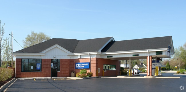
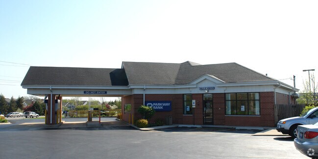
Property Record
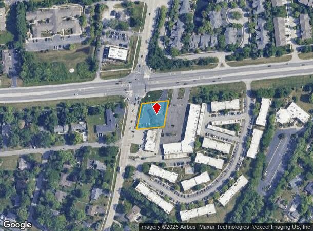
22W555 Butterfield Rd, Glen Ellyn, IL 60137
NEARBY LISTINGS FOR SALE OR LEASE
Property Detail
22W555 Butterfield Rd
05-35-107-033
Daughertys Assmt Plat
Commercialnec
DAUGHERTYS ASSMT PLAT N 150FT OF W 157FT MEAS // TO PARK BLVD
X
DuPage
17043C0154J
Illinois
2024
0.51 AC
2024
Western East/West Corr
842706
Chicago
3,060 SF
Chicago-Naperville-Elgin, IL-IN-WI
DEMOGRAPHICS near 22W555 Butterfield Rd
1 Mile
3 Mile
5 Mile
2024 Total Population
4,174
82,409
260,281
2029 Population
3,929
81,183
256,648
Pop Growth 2024-2029
(5.87%)
(1.49%)
(1.40%)
Average Age
43
41
41
2024 Total Households
1,587
32,668
102,961
HH Growth 2024-2029
(6.11%)
(1.48%)
(1.38%)
Median Household Inc
$119,093
$101,445
$101,912
Avg Household Size
2.60
2.40
2.40
2024 Avg HH Vehicles
2.00
2.00
2.00
Median Home Value
$373,165
$384,532
$385,611
Median Year Built
1970
1975
1975
Nearby Places
Map Layers
Map Styles
 Street
 Aerial
- Restaurants
- Banks
- Shops
- Fitness
- Groceries
PUBLIC TRANSPORTATION
COMMUTER RAIL
Lisle Station (Burlington Northern-Santa Fe Railway Line - Northeast Illinois Regional Commuter Railroad (Metra))
DRIVE
WALK
Distance
Lisle Station (Burlington Northern-Santa Fe Railway Line - Northeast Illinois Regional Commuter Railroad (Metra))
8 min
2.6 mi
College Avenue Station (Union Pacific West Line - Northeast Illinois Regional Commuter Railroad (Metra))
DRIVE
WALK
Distance
College Avenue Station (Union Pacific West Line - Northeast Illinois Regional Commuter Railroad (Metra))
11 min
4.1 mi
AIRPORT
Chicago Midway International
DRIVE
WALK
Distance
Chicago Midway International
34 min
20.4 mi
Chicago O'Hare International
DRIVE
WALK
Distance
Chicago O'Hare International
33 min
21.3 mi
Nearby Properties
Address
Land Use
TOTAL SIZE
Lot Size
Zoning
Address
Land Use
TOTAL SIZE
Lot Size
Zoning
83.99 AC
Address
Land Use
TOTAL SIZE
Lot Size
Zoning
365,658 SF
5 AC
C
Address
Land Use
TOTAL SIZE
Lot Size
Zoning
834,293 SF
40.24 AC
M
Address
Land Use
TOTAL SIZE
Lot Size
Zoning
534,583 SF
16.04 AC
C
Address
Land Use
TOTAL SIZE
Lot Size
Zoning
376,629 SF
16.26 AC
C
Address
Land Use
TOTAL SIZE
Lot Size
Zoning
12.21 AC
Address
Land Use
TOTAL SIZE
Lot Size
Zoning
8.08 AC
C
Address
Land Use
TOTAL SIZE
Lot Size
Zoning
295,773 SF
17.45 AC
M
Address
Land Use
TOTAL SIZE
Lot Size
Zoning
264,227 SF
17.12 AC
M
Address
Land Use
TOTAL SIZE
Lot Size
Zoning
254,992 SF
14.21 AC
M
Address
Land Use
TOTAL SIZE
Lot Size
Zoning
300,104 SF
19.49 AC
M
Address
Land Use
TOTAL SIZE
Lot Size
Zoning
254,201 SF
27.84 AC
Address
Land Use
TOTAL SIZE
Lot Size
Zoning
20.05 AC
C
Address
Land Use
TOTAL SIZE
Lot Size
Zoning
319,650 SF
20.12 AC
M
Address
Land Use
TOTAL SIZE
Lot Size
Zoning
200,237 SF
2.98 AC
C
Address
Land Use
TOTAL SIZE
Lot Size
Zoning
9.18 AC
C
Address
Land Use
TOTAL SIZE
Lot Size
Zoning
8.36 AC
C
Address
Land Use
TOTAL SIZE
Lot Size
Zoning
552,111 SF
4.48 AC
C
Address
Land Use
TOTAL SIZE
Lot Size
Zoning
201,048 SF
20.24 AC
Address
Land Use
TOTAL SIZE
Lot Size
Zoning
239,756 SF
13.43 AC
M
Address
Land Use
TOTAL SIZE
Lot Size
Zoning
259,374 SF
27.66 AC
C
Address
Land Use
TOTAL SIZE
Lot Size
Zoning
2.37 AC
Address
Land Use
TOTAL SIZE
Lot Size
Zoning
14.68 AC
I
Address
Land Use
TOTAL SIZE
Lot Size
Zoning
13.89 AC
M
Address
Land Use
TOTAL SIZE
Lot Size
Zoning
11.15 AC
M
Address
Land Use
TOTAL SIZE
Lot Size
Zoning
162,819 SF
19.82 AC
C
Address
Land Use
TOTAL SIZE
Lot Size
Zoning
190,058 SF
11.77 AC
Address
Land Use
TOTAL SIZE
Lot Size
Zoning
162,815 SF
11.60 AC
M
Address
Land Use
TOTAL SIZE
Lot Size
Zoning
13.44 AC
C
Address
Land Use
TOTAL SIZE
Lot Size
Zoning
291,840 SF
14.34 AC
The World's #1 Commercial Real Estate Marketplace
Connect with us
© 2025 CoStar Group
The information above has been obtained from sources believed reliable. While we do not doubt its accuracy we have not verified it and make no guarantee, warranty or representation about it. It is your responsibility to independently confirm its accuracy and completeness. Any projections, opinions, assumptions, or estimates used are for example only and do not represent the current or future performance of the property. The value of this transaction to you depends on tax and other factors which should be evaluated by your tax, financial, and legal advisors. You and your advisors should conduct a careful, independent investigation of the property to determine to your satisfaction the suitability of the property for your needs.