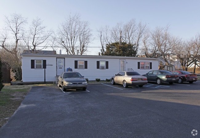
Property Record
23 Carpenter St, Dover, DE 19901

Property Detail
23 Carpenter St
2-00-08600-01-4000-000
W SD OF ST HWY DOVER-KITTS HUMMOCK 12.4565 A
Commercialnec
KENT
RMH
Delaware
AE The base floodplain where base flood elevations are provided. AE Zones are now used on new format FIRMs instead of A1-A30 Zones.
12.50 AC
2025
Outer Dover-Kent County
2025
Philadelphia
041200
Dover, DE
4,800 SF
NEARBY LISTINGS FOR SALE OR LEASE
-
-
View all Dover listings for sale on LoopNet.com
DEMOGRAPHICS near 23 Carpenter St
1 mile
3 mile
5 mile
2025 Total Population
5,375
36,949
76,703
2030 Population
5,825
38,911
80,396
Pop Growth 2025-2030
+ 8.37%
+ 5.31%
+ 4.81%
Average Age
32
38
39
2025 Total Households
2,688
14,894
29,588
HH Growth 2025-2030
+ 12.95%
+ 6.67%
+ 5.42%
Median Household Inc
$72,313
$71,247
$66,471
Avg Household Size
2.00
2.40
2.40
2025 Avg HH Vehicles
2.00
2.00
2.00
Median Home Value
$474,096
$318,313
$305,326
Median Year Built
2010
1991
1989
Nearby Places
Map Layers
Map Styles
 Street
 Aerial
Transit
 Traffic
 Biking
Places
Listings with unknown addresses are not visible on the map
- Restaurants
- Banks
- Shops
- Fitness
- Groceries
Nearby Properties
Address
Land Use
TOTAL SIZE
Lot Size
Zoning
Address
Land Use
TOTAL SIZE
Lot Size
Zoning
136,308 SF
2,301.50 AC
R20
Address
Land Use
TOTAL SIZE
Lot Size
Zoning
824,144 SF
12.10 AC
IO
Address
Land Use
TOTAL SIZE
Lot Size
Zoning
Address
Land Use
TOTAL SIZE
Lot Size
Zoning
494,672 SF
35.80 AC
NA
Address
Land Use
TOTAL SIZE
Lot Size
Zoning
189,363 SF
123.90 AC
IO
Address
Land Use
TOTAL SIZE
Lot Size
Zoning
172,440 SF
28.86 AC
RM2
Address
Land Use
TOTAL SIZE
Lot Size
Zoning
322,096 SF
18.20 AC
SC2
Address
Land Use
TOTAL SIZE
Lot Size
Zoning
135,552 SF
39.05 AC
AC
Address
Land Use
TOTAL SIZE
Lot Size
Zoning
228,076 SF
15.50 AC
BG
Address
Land Use
TOTAL SIZE
Lot Size
Zoning
129,471 SF
TND
Address
Land Use
TOTAL SIZE
Lot Size
Zoning
108,450 SF
11 AC
RM
Address
Land Use
TOTAL SIZE
Lot Size
Zoning
116,604 SF
3.20 AC
IO
Address
Land Use
TOTAL SIZE
Lot Size
Zoning
187,104 SF
7.80 AC
RM1
Address
Land Use
TOTAL SIZE
Lot Size
Zoning
72,794 SF
11.57 AC
IO
Address
Land Use
TOTAL SIZE
Lot Size
Zoning
Address
Land Use
TOTAL SIZE
Lot Size
Zoning
Address
Land Use
TOTAL SIZE
Lot Size
Zoning
434.50 AC
DAFB
Address
Land Use
TOTAL SIZE
Lot Size
Zoning
243,410 SF
43.20 AC
IPM
Address
Land Use
TOTAL SIZE
Lot Size
Zoning
Address
Land Use
TOTAL SIZE
Lot Size
Zoning
55,272 SF
11.30 AC
IO
Address
Land Use
TOTAL SIZE
Lot Size
Zoning
Address
Land Use
TOTAL SIZE
Lot Size
Zoning
74,521 SF
15.90 AC
IO
Address
Land Use
TOTAL SIZE
Lot Size
Zoning
97,489 SF
8.69 AC
SC2
Address
Land Use
TOTAL SIZE
Lot Size
Zoning
23,122 SF
8.90 AC
SC1
Address
Land Use
TOTAL SIZE
Lot Size
Zoning
68,076 SF
2.63 AC
TND
Address
Land Use
TOTAL SIZE
Lot Size
Zoning
126,854 SF
10.90 AC
C4
Address
Land Use
TOTAL SIZE
Lot Size
Zoning
2,768 SF
335.80 AC
AC
Address
Land Use
TOTAL SIZE
Lot Size
Zoning
62,572 SF
53 AC
RS1
Address
Land Use
TOTAL SIZE
Lot Size
Zoning
93,954 SF
2.80 AC
IO
Address
Land Use
TOTAL SIZE
Lot Size
Zoning
64,067 SF
33.61 AC
AC
The World's #1 Commercial Real Estate Marketplace
Connect with us
© 2026 CoStar Group
The information above has been obtained from sources believed reliable. While we do not doubt its accuracy we have not verified it and make no guarantee, warranty or representation about it. It is your responsibility to independently confirm its accuracy and completeness. Any projections, opinions, assumptions, or estimates used are for example only and do not represent the current or future performance of the property. The value of this transaction to you depends on tax and other factors which should be evaluated by your tax, financial, and legal advisors. You and your advisors should conduct a careful, independent investigation of the property to determine to your satisfaction the suitability of the property for your needs.