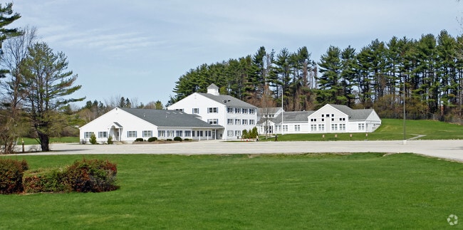
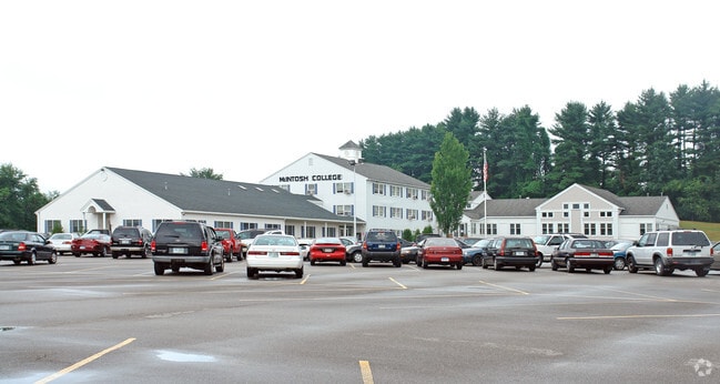
Property Record
23 Cataract Ave, Dover, NH 03820
Current Lease Availabilities
NEARBY LISTINGS FOR SALE OR LEASE
Property Detail
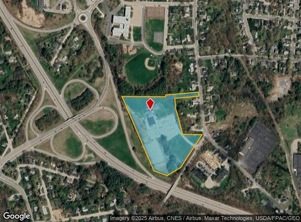
23 Cataract Ave
DOVR-013023
Strafford
Commercialnec
New Hampshire
X
12.13 AC
33017C0320E
Strafford County
2024
Boston
2024
Boston-Cambridge-Newton, MA-NH
081300
DEMOGRAPHICS near 23 Cataract Ave
1 mile
3 mile
5 mile
2024 Total Population
10,203
31,249
62,903
2029 Population
10,748
32,765
65,809
Pop Growth 2024-2029
+ 5.34%
+ 4.85%
+ 4.62%
Average Age
40
40
38
2024 Total Households
5,074
14,220
24,306
HH Growth 2024-2029
+ 5.54%
+ 5.03%
+ 5.07%
Median Household Inc
$85,694
$100,168
$99,705
Avg Household Size
2.00
2.10
2.30
2024 Avg HH Vehicles
2.00
2.00
2.00
Median Home Value
$388,942
$373,989
$369,736
Median Year Built
1971
1974
1974
Nearby Places
Map Layers
Map Styles
 Street
 Aerial
Transit
 Traffic
 Biking
Places
Listings with unknown addresses are not visible on the map
- Restaurants
- Banks
- Shops
- Fitness
- Groceries
PUBLIC TRANSPORTATION
COMMUTER RAIL
Dover (Downeaster - Amtrak)
Drive
Walk
Distance
Dover (Downeaster - Amtrak)
6 min
1.9 mi
Durham (Downeaster - Amtrak)
Drive
Walk
Distance
Durham (Downeaster - Amtrak)
13 min
5.9 mi
AIRPORT
Portsmouth International at Pease
Drive
Walk
Distance
Portsmouth International at Pease
17 min
9.4 mi
Freight Ports
Portland, ME
Drive
Walk
Distance
Portland, ME
72 min
50.4 mi
Nearby Properties
Address
Land Use
TOTAL SIZE
Lot Size
Zoning
Address
Land Use
TOTAL SIZE
Lot Size
Zoning
24.83 AC
R-20
Address
Land Use
TOTAL SIZE
Lot Size
Zoning
1.26 AC
CBD-G
Address
Land Use
TOTAL SIZE
Lot Size
Zoning
220.20 AC
IT
Address
Land Use
TOTAL SIZE
Lot Size
Zoning
14 AC
RA RE
Address
Land Use
TOTAL SIZE
Lot Size
Zoning
20.03 AC
R-20
Address
Land Use
TOTAL SIZE
Lot Size
Zoning
7.84 AC
C
Address
Land Use
TOTAL SIZE
Lot Size
Zoning
3.66 AC
IT
Address
Land Use
TOTAL SIZE
Lot Size
Zoning
50.52 AC
RM-SU*
Address
Land Use
TOTAL SIZE
Lot Size
Zoning
3.40 AC
CBD-M
Address
Land Use
TOTAL SIZE
Lot Size
Zoning
15.46 AC
C
Address
Land Use
TOTAL SIZE
Lot Size
Zoning
11.80 AC
R-12*
Address
Land Use
TOTAL SIZE
Lot Size
Zoning
26.40 AC
IT*
Address
Land Use
TOTAL SIZE
Lot Size
Zoning
60.41 AC
R-40
Address
Land Use
TOTAL SIZE
Lot Size
Zoning
3.35 AC
CBD-G
Address
Land Use
TOTAL SIZE
Lot Size
Zoning
3.66 AC
C
Address
Land Use
TOTAL SIZE
Lot Size
Zoning
7.92 AC
R-12
Address
Land Use
TOTAL SIZE
Lot Size
Zoning
15.46 AC
G
Address
Land Use
TOTAL SIZE
Lot Size
Zoning
0.22 AC
CBD-G
Address
Land Use
TOTAL SIZE
Lot Size
Zoning
4.15 AC
R-12
Address
Land Use
TOTAL SIZE
Lot Size
Zoning
11.08 AC
RM-U
Address
Land Use
TOTAL SIZE
Lot Size
Zoning
11.47 AC
IT
Address
Land Use
TOTAL SIZE
Lot Size
Zoning
35.86 AC
R-40
Address
Land Use
TOTAL SIZE
Lot Size
Zoning
7.33 AC
G
Address
Land Use
TOTAL SIZE
Lot Size
Zoning
4.15 AC
RM-U
Address
Land Use
TOTAL SIZE
Lot Size
Zoning
12.60 AC
IT
Address
Land Use
TOTAL SIZE
Lot Size
Zoning
9.29 AC
R-12*
Address
Land Use
TOTAL SIZE
Lot Size
Zoning
5 AC
C
Address
Land Use
TOTAL SIZE
Lot Size
Zoning
38.27 AC
RM-U
Address
Land Use
TOTAL SIZE
Lot Size
Zoning
8.96 AC
IT
Address
Land Use
TOTAL SIZE
Lot Size
Zoning
6.81 AC
CM
The World's #1 Commercial Real Estate Marketplace
Connect with us
© 2026 CoStar Group
The information above has been obtained from sources believed reliable. While we do not doubt its accuracy we have not verified it and make no guarantee, warranty or representation about it. It is your responsibility to independently confirm its accuracy and completeness. Any projections, opinions, assumptions, or estimates used are for example only and do not represent the current or future performance of the property. The value of this transaction to you depends on tax and other factors which should be evaluated by your tax, financial, and legal advisors. You and your advisors should conduct a careful, independent investigation of the property to determine to your satisfaction the suitability of the property for your needs.