Property Record
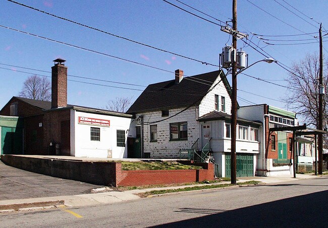
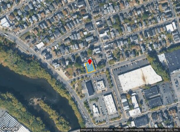
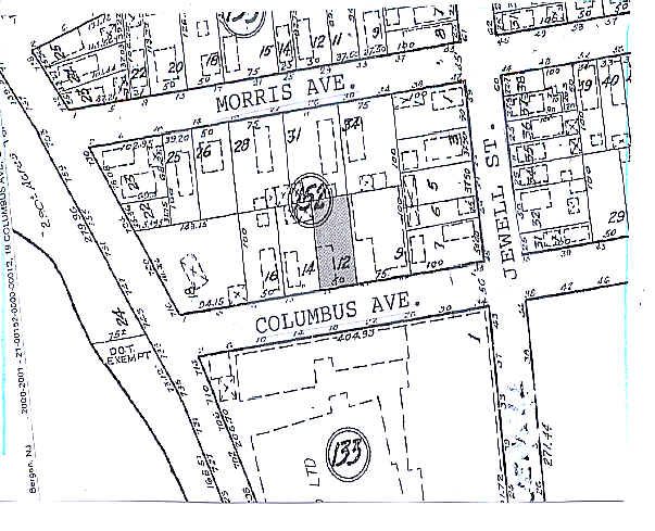
23 Columbus Ave, Garfield, NJ 07026
NEARBY LISTINGS FOR SALE OR LEASE
Property Detail
23 Columbus Ave
New York-Jersey City-White Plains, NY-NJ
7500 SF
21-00152-0000-00009
Bergen
Industrialgeneral
New Jersey
X
9
34031C0238G
0.17 AC
2024
Route 46 Corridor
2025
Northern New Jersey
021200
DEMOGRAPHICS near 23 Columbus Ave
1 Mile
3 Mile
5 Mile
2024 Total Population
44,782
307,593
657,971
2029 Population
42,964
297,878
640,273
Pop Growth 2024-2029
(4.06%)
(3.16%)
(2.69%)
Average Age
37
39
39
2024 Total Households
14,776
104,026
229,475
HH Growth 2024-2029
(4.24%)
(3.24%)
(2.68%)
Median Household Inc
$64,305
$69,166
$75,894
Avg Household Size
2.90
2.90
2.70
2024 Avg HH Vehicles
2.00
2.00
2.00
Median Home Value
$402,694
$416,928
$429,847
Median Year Built
1948
1952
1954
Nearby Places
Map Layers
Map Styles
 Street
 Aerial
- Restaurants
- Banks
- Shops
- Fitness
- Groceries
PUBLIC TRANSPORTATION
COMMUTER RAIL
Plauderville (Bergen County/Port Jervis Line - NJ Transit Commuter Rail (NJ Transit))
DRIVE
WALK
Distance
Plauderville (Bergen County/Port Jervis Line - NJ Transit Commuter Rail (NJ Transit))
4 min
1.4 mi
Garfield (Bergen County/Port Jervis Line - NJ Transit Commuter Rail (NJ Transit))
DRIVE
WALK
Distance
Garfield (Bergen County/Port Jervis Line - NJ Transit Commuter Rail (NJ Transit))
4 min
1.8 mi
AIRPORT
Newark Liberty International
DRIVE
WALK
Distance
Newark Liberty International
23 min
17.4 mi
LaGuardia
DRIVE
WALK
Distance
LaGuardia
36 min
23.7 mi
John F Kennedy International
DRIVE
WALK
Distance
John F Kennedy International
50 min
34.8 mi
Freight Ports
Maher Terminal
DRIVE
WALK
Distance
Maher Terminal
29 min
17.6 mi
Nearby Properties
Address
Land Use
TOTAL SIZE
Lot Size
Zoning
Address
Land Use
TOTAL SIZE
Lot Size
Zoning
8.75 AC
Address
Land Use
TOTAL SIZE
Lot Size
Zoning
7.10 AC
R-3
Address
Land Use
TOTAL SIZE
Lot Size
Zoning
8.66 AC
CH1
Address
Land Use
TOTAL SIZE
Lot Size
Zoning
4.80 AC
Address
Land Use
TOTAL SIZE
Lot Size
Zoning
25.50 AC
B2
Address
Land Use
TOTAL SIZE
Lot Size
Zoning
26,816 SF
25.50 AC
POP
Address
Land Use
TOTAL SIZE
Lot Size
Zoning
Address
Land Use
TOTAL SIZE
Lot Size
Zoning
286,500 SF
26.90 AC
LL
Address
Land Use
TOTAL SIZE
Lot Size
Zoning
82.74 AC
Address
Land Use
TOTAL SIZE
Lot Size
Zoning
16.94 AC
R2
Address
Land Use
TOTAL SIZE
Lot Size
Zoning
24.35 AC
Address
Land Use
TOTAL SIZE
Lot Size
Zoning
13.80 AC
Address
Land Use
TOTAL SIZE
Lot Size
Zoning
152,050 SF
1.96 AC
B-1
Address
Land Use
TOTAL SIZE
Lot Size
Zoning
13.36 AC
Address
Land Use
TOTAL SIZE
Lot Size
Zoning
5.40 AC
RB
Address
Land Use
TOTAL SIZE
Lot Size
Zoning
Address
Land Use
TOTAL SIZE
Lot Size
Zoning
31.63 AC
I
Address
Land Use
TOTAL SIZE
Lot Size
Zoning
18.14 AC
R3
Address
Land Use
TOTAL SIZE
Lot Size
Zoning
6,712 SF
92 AC
C
Address
Land Use
TOTAL SIZE
Lot Size
Zoning
21.80 AC
R-A3
Address
Land Use
TOTAL SIZE
Lot Size
Zoning
Address
Land Use
TOTAL SIZE
Lot Size
Zoning
6.66 AC
RM
Address
Land Use
TOTAL SIZE
Lot Size
Zoning
0.01 AC
Address
Land Use
TOTAL SIZE
Lot Size
Zoning
8.20 AC
Address
Land Use
TOTAL SIZE
Lot Size
Zoning
95,682 SF
6.44 AC
LL
Address
Land Use
TOTAL SIZE
Lot Size
Zoning
16.05 AC
Address
Land Use
TOTAL SIZE
Lot Size
Zoning
764,364 SF
16.60 AC
I-2
Address
Land Use
TOTAL SIZE
Lot Size
Zoning
0.01 AC
Address
Land Use
TOTAL SIZE
Lot Size
Zoning
11.87 AC
Address
Land Use
TOTAL SIZE
Lot Size
Zoning
2.42 AC
The World's #1 Commercial Real Estate Marketplace
Connect with us
© 2025 CoStar Group
The information above has been obtained from sources believed reliable. While we do not doubt its accuracy we have not verified it and make no guarantee, warranty or representation about it. It is your responsibility to independently confirm its accuracy and completeness. Any projections, opinions, assumptions, or estimates used are for example only and do not represent the current or future performance of the property. The value of this transaction to you depends on tax and other factors which should be evaluated by your tax, financial, and legal advisors. You and your advisors should conduct a careful, independent investigation of the property to determine to your satisfaction the suitability of the property for your needs.